SwiftSure
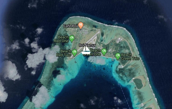
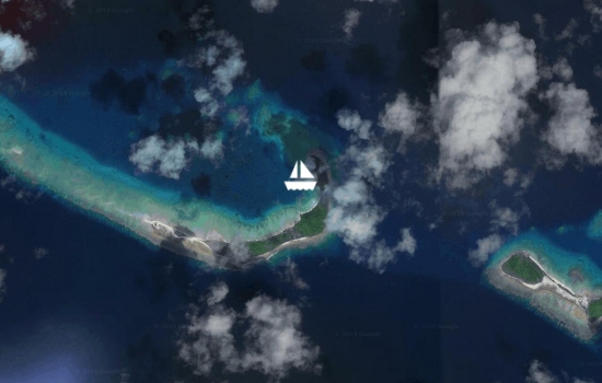
Anchored at Roi-Namur off Red Beach at the US Army Base. The storm forecasted for the northern Marshall Islands is upon us. We are glad we made the trip down from Rongerik where there is little protection to this more protected place. The storm is passing us well to the east, so we so we are not getting it's full force. We are in the lee of the Kwajelain Atoll with winds overnight to 45kts here. Anchored in deep white sand with good holding. We have anchored here several times before on our previous visits to the base. s/v Apolima is in sight anchored 2.5nm south of us at "3rd" Island and is doing fine. We expect the storm to move past us later today on its way to Rongelap/Rongerik Atolls. All is well aboard.
Avg: 6.1knts
24hr: 146.2nm
12nm to the North Pass of Kwajalein Atoll. Sunrise in a few minutes. Clear, moonless night passage with 3m swells just aft of the beam, steady winds to 18-22 g28. We will proceed into the lagoon with good light in 2 hours. We have s/v Apolima 1nm from our beam, also heading to Kwajalein.
Preparing to get underway. Planning to leave Beautiful and Isolated Rongerik Atoll for Kwajalein Atoll, in the next few hours. An overnight sail to the North Pass of Kwajalein Atoll.
Anchored in Rongerik Atoll, completely un-inhabited, 20 islands make up this lagoon. Most with white powder beaches and coconut palms. Every shade of Turquoise surrounds us. Paradise found.
10nm miles from the South Pass of Rongerik Atoll. Nice overnight passage from Likiep Atoll. Sunrise in a few minutes, we'll proceed into the pass with good light. We passed s/v Apolima yesterday evening on this same heading; not currently in visual or radar range.
Avg: 8.9knts
24hr: 213.9nm
Nice fast passage from Majuro consistent wind in the high teens, moderate seas. We are 14nm from the south pass of Likiep Atoll, ETA 8:45am or 20:45Z.
Leaving Majuro for what could be the last time. We are heading for Likiep Atoll to spend a few months in the northern Marshalls, departing for FSM after the New Year. Christmas in Kwajalein. All plans written in "Sand Script"
Motoring on a glassy lagoon from Eneko Island to Majuro. We spent the week diving, snorkeling, beach fun, as well as boat projects, anchored off this small day resort. Water temps as high as 36c at the surface, vis at 30+m.
Moved to Taroa Island On Maleolap Atoll. Going to dive the WW2 wreck of the Terashima Maru this morning. Still have these these unusual westerly winds, thankfully the are light or the fetch would be very uncomfortable.
Anchored at Airik Island, Maleolap Atoll. Yet another warm and sunny day. New solar panels are keeping far ahead of our power consumption, even with two visitors on board (Gingers parents). Haven't run the gen-set in since the solar installation except to make water.
Moored at Enemonet Island in the Majuro Lagoon. Enjoying this lovely calm bay doing some boat maintenance. Preparing for the arrival of our new solar panels. 1300 watts worth!
Preparing to depart our Majuro Mooring for the Enigu Island. Lagoon very choppy with West Winds.
On our mooring in Majuro. Yachties Night Out at the MIR last night, Team s/v Seal & Viadante took the cash at Quiz night. The US Post Office was glad to see us yesterday, to free up some shelf space where our packages were being stored. All well on board.
Avg: 5.7knts
24hr: 136.7nm
sp: 7.2 24NM miles to run to Majuro Pass. Overcast and light rain falling. Too cloudy for the Meteor Shower.
Departed Kwajalein Atoll, last evening for Majuro Atoll 151nm to run. Lumpy conditions with variable wind speeds. All is well on board
Enjoying the US Base hospitality here on Kwajalein on the guest dock. INVEST 96 is going over us at the moment. We'll head south to Majuro with any wind from the NE in the coming week.
Arrived Kajalein Yacht Club yesterday afternoon. We are resting comfortably on the guest dock, first dock since Apia in 2016! This REALLY is an American Town. We'll enjoy the change for a week or so before heading to Majuro.
Preparing to raise the anchor. Departing Roi-Namur Island for Kwajalein Island. 42nm run all inside the Kwajalein Atoll. (the worlds largest)
Anchored at Roi-Namur Island on Kwajalein. We are enjoying the hospitality of the US military base here. Thanks to our sponsors, we have full access to all the base facilities. We'll get caught up on wifi (first wifi in 3months!!!) in the next few days. We have loaner bikes, we haven't ridden bikes in several years good to be back on the road!
Avg: 7.7knts
24hr: 183.9nm
Just after sunrise and 10nm miles from the north pass of Kwajalein, heading for the US Base at Roi-Namur, just east of the pass. Wind shifted to the SE this morning!
Just leaving Tufa Island, Rongelap for Roi-Namur, Kwajalein. Nice afternoon for a sail. This is an overnight passage hopefully timed to arrive at the north pass of Kwaj after sunrise.
Moved inside Rongelap Lagoon to this gorgeous nearly 360 protected anchorage: Tufa Island. Mark1 eyeball nav the last nm. White sand beaches with lots of coconuts and beautiful reefs & bommies. This may be paradise found. Caught a Rainbow Runner on the way over! No one lives in this paradise, hard to believe. NASA rocket launch tonight from Kwajalein, should have excellent seats.
Moved inside the lagoon to Rongelap Island, the main habitation for this atoll. Anchored off the municipal dock. Population about 30-40 workers building new homes for the former displaced inhabitants. A modern ghost town, complete with an empty resort, wonderful concrete roads and paved airport with new terminal, (but no air service) 24/7 electricity (free) and RO water (free).
Anchored Laboredj Island on Rongelap Atoll.
Underway Rongerik Atoll to Rongelap Atoll.
Avg: 7.8knts
24hr: 188.3nm
sp: 7.8 Timing our arrival for light at the south pass of Rongerik Atoll. Just now sunrise with 8nm to run.
Underway from Likiep Atoll to Rongerik Atoll

We are anchored on the deserted island of Enej in the Likiep Atoll.
Anchored in Likiep, unique village here settled by Europeans in the 1890s. We are enjoying this lovely quiet bay with winds outside at 23kts and 2.5m seas. Just gifted with 4 dozen cay limes and 20 drinking nuts: Sundowners!
Inroute Wotje Atoll to Likiep Atoll
Still in the Wotje Atoll but moved north to beautiful Ormed Island. Its one of those places with blazing white sand beaches and every shade of turquoise water.
Anchored off the old Japanese Seaplane ramp, Wotje, RMI. Beautiful calm anchorage here. Sunken ships and aircraft in the lagoon. Japanese bunkers, aircraft and war relics abound on shore. Great place for divers and history buffs.
Slowing making our way thru the atoll in the predawn moonlight to the NW Pass of Maloelap Atoll, enroute to Wotje Atoll.
Anchored off the old Japanese Pier at Taroa, Maleolap.
Avg: 6.9knts
24hr: 166.8nm
6nm miles from the Enijun Pass of Maleolap. Sun is just up. Squally night early, later cleared. Looks to be a nice mostly sunny day.
Underway tonight for Maleolap Atoll, just departed the Majuro. Plan to arrive after dawn at Maleolap south pass. Rendevous with Blowin' Bubbles & Halo.
Moored at Enigu Island. Contrary winds, Numerous Squalls, decided for us to hang around Majuro Lagoon for another day, before departing for Maleolap. The ITCZ is over us making the weather even less predictable than usual.
Moored at Anememwot, Majuro Lagoon. Preparing to get underway for Maleolap, overnight passage tonight.
No blogs available for this yacht.