SwiftSure
Heading to Malakal Harbor this morning, two hour run.

Full load of fuel, water, nitrox and provisions, headed to the Rock Islands. We'll be back in Koror, whenever. Enjoying this beautiful place.

Hanging here in Palau's Malakal Harbor on our RBYC mooring. It is sad to see this place shutting down. No more tourists are arriving and many in the diving and hotel industry are being laid-off. A number of foreign nationals have left on the last few flights. United will keep one weekly flight to Guam. We were planning to be here until May so no big change for us.
Provisioning is still arriving via container, we expect the stores will be overstocked for a while as restaurants/hotels scale back or shutdown.
Staying longer in Palau is not a hardship! Most every country in this part of the Pacific is not allowing yachts entry or to move around, in country. We can sail to the other islands of the group and dive in the national park. All is Well on Board
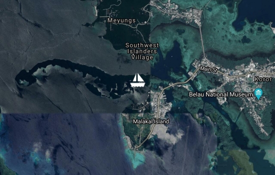
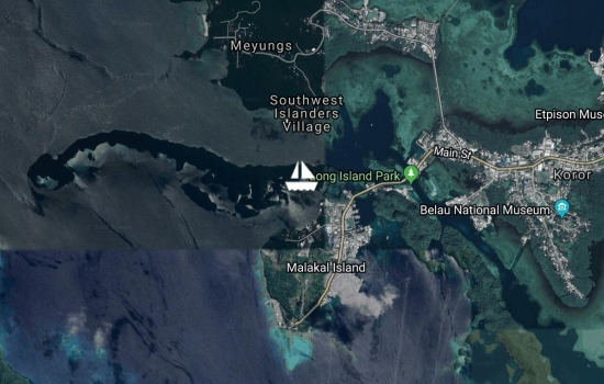
We are back on our RBYC mooring in Koror for a few days.
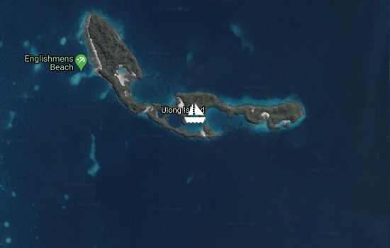
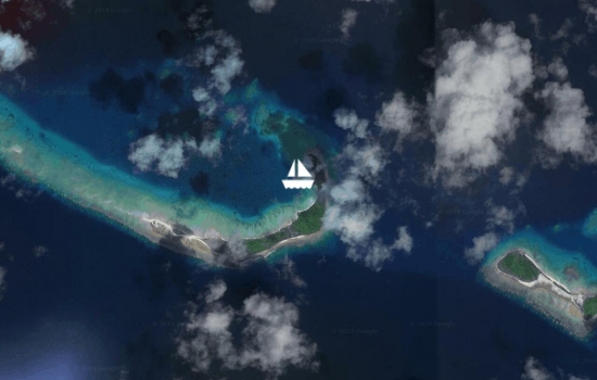
Just arrive in Swiftlet Bay, Ulong, Palau. Perfect deserted island marine lake, we are snuggly surrounded by green hills with only a shallow narrow opening. Swinging room for one. So shallow even Cat drivers hesitate to cross the reef entrance. ;-)

Hanging on our mooring at the Royal Belau YC. Still enjoying Palau and still receiving replacement and upgrade gear. New code 0 sail, main-sail bag, and trampolines are installed. Lithium batteries arrived yesterday, direct from China; more work! We'll head to the gorgeous Rock Islands for a few days, get in a some dive/fun time before we start the lithium install.

Still enjoying Palau!
We are doing some replacements/upgrades: New Code 0, Mainsail Bag, Trampolines, Lithium Batteries and some related electrical gear. This is the last place we will have access to the US Postal System as we proceed west from here. All of Micronesia is still in the US Domestic Postal System, an odd legacy we happily enjoy. Our US internet purchases arrive in 5-7 days.
No plans to depart soon.

A beautiful day here in Koror, Palau, with SwiftSure moored in light air and calm sea. TS Phanfone passed just to the north of us yesterday and is now 150nm away. Its on its way to the Philippines, where it may become a full typhoon. It's passing was a non-event here, light air and no rain. We'll be in Palau this Christmas #6 on board. All is well and Merry Christmas to all.
Back in Koror at the RBYC after a 10-day swing into the Rock Islands. Truly one of the world's most beautiful places, with it's unique "mushroom" shaped islands and labyrinth of marine lakes. Jellyfish lake is also a unique must-do adventure in the Rock Islands.
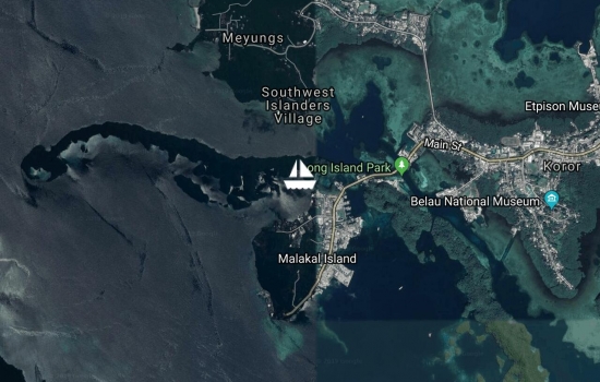
Moored at our new home: the Royal Belau Yacht Club. We are looking forward to staying a while and exploring all the islands of Palau, above and below the surface.
Avg: 6.5knts
24hr: 156.1nm
We have had Palau in sight for several hours even before sunrise. It's a high green island. 14nm to our approach way point, 4 more to the harbor channel entrance. Calm overnight with winds 5kts or less, flat seas, and no rain. The Yanmars are getting a workout. We dodged a whole fleet of FADs around local midnight. Thankfully they all had AIS beacons. Welcome rainbow ahead. AWOB
Avg: 5.1knts
24hr: 123.1nm
We departed Yap with beautiful moderate wind, sunny & dry day AND similar routing forecast. It was quite wrong. Leaving Yap in sunshine the weather quickly turned into a series of squalls, up to 45kts. (after the fact, they changed the "forecast") We had a quiet motor sail most of the night with the squalls ending early yesterday evening and an unforecasted tail wind & wave assist. Still a few showers around this morning. AWOB.

Preparing to Depart Yap for Palau. Roller furling is not ocean-ready so we'll leave it furled for this trip. I'll have the repair parts meet us in Palau. Mainsail & Diesels for the trip.

Avg: 2.7knts
24hr: 64nm
Today finds us quietly anchored in the harbor at Yap Island. We made the anchorage at sunset yesterday. We have seen little of Yap except the Entry Officials, who all happily came last evening to clear us in. It was overtime. We've got a few projects to work on then on to shore to pickup packages at the US Post Office and explore the town.
Avg: 4.9knts
24hr: 117.2nm
Motorsailing in boisterous conditions with full main. Genoa is out of action with a problem at the mast head, sea too large at 2-3m to go aloft to inspect/repair. We'll wait for the calm waters of Yap Anchorage. Our speed was greatly reduced last night as a result. We are 51nm miles from the entrance, we are hopeful that we will arrive an hour or two before sunset. It is one of the best lit commercial entrances in this part of the pacific. Otherwise AIWOB.
Just preparing to depart Sorol Atoll for Yap Atoll. ETA: PM tomorrow
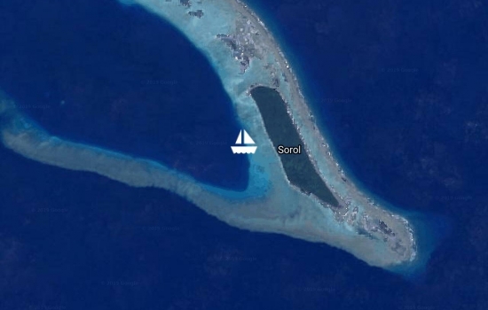
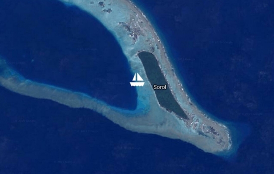
Sorol Atoll, we arrived yesterday afternoon at this "wow" atoll. Five islands, one large lush one, all connected by a wide protecting reef and large sand banks. They are all uninhabited with lots of marine and bird life. At least 3 wrecks on the outer reefs. Water Vis is 100'+. We were welcomed by a school of dolphins on the outside, followed by pulling in a Rainbow Runner and a Tunney, passing a mating pair of large sea turtles, all before the anchor was down. We have gang of young, friendly Blacktips keeping us company at anchor. Our new favorite atoll.
Avg: 5.7knts
24hr: 136.9nm
27nm to the Sorol Atoll. We are motor-sailing on a glassy sea. Perfect sunrise w/o any clouds to obstruct this morning. Sailed and motored as the wind came and went last night. One squall of 25kts gave us a nice lift for a few hours. We expect to make the pass with good light. Noticed that Sorol is referenced on my e-charts as "under US protection", we are curious, no others in the FSM. Send us a sailmail if you know wdh6825@sailmail.com
Avg: 3.8knts
24hr: 92.4nm
Good sailing yesterday but motor-sailing last 6 hours in very light, variable, winds, sea flat. We avoided a few gusty squalls up to 25kts, around sunset yesterday, they dissipated and took their wind with them. Trace of rain overnight in the form of sprinkles. Winds predicted to be light today, likely we'll be moving all day with a Yanmar breeze. 140nm to Sorol Atoll.
Just raising the anchor. Our happy time in Woleai has come to an end. A must stop if your are cruising this way. We have a south wind so we'll ride it west to uninhabited Sorol Atoll. A 2 day sail in these conditions. From there we'll head to Yap, our last stop in the FSM.
Anchored in Woleai Atoll yesterday morning. We exchanged greetings with the two Paramount Chiefs, who granted us permission to stay as long as we want and enjoy the islands and reefs. They have a full time generator here and "street lights" even three pick-up trucks. There is a regional high school and a limited satellite up-link to the net. They have repaired the old Japanese runway to an active runway with a 16-pax CIA plane every two weeks. Very modern people but still living the traditional way, women are separate from the men most of the day and wear lava-lava skirts and are topless. Men wear loin cloths. BTW we gifted our turtle meat to the Chiefs, who happily accepted and commented they had taken too many and now rarely saw them here.
Avg: 5.2knts
24hr: 123.9nm
Nice calm night, intervals of sailing, but mostly motor-sailing in light air. Beautiful sunny morning. 20nm to Woleai Atoll pass. ETA 11:am local. AIWOB.
Just figured out how to use
Preparing to depart uninhabited Olimarao Atoll for Woleai Atoll, 124nm. Woleai is inhabited and MAY even have wifi. NHOB. We have been waiting on some wind but what little there has been is from the west. So with 6kts from the NW we'll attempt to close-reach West to Woleai with the liberal application of hydrocarbons.
We are anchored in Olimarao Atoll. A small atoll with only two palm covered islands but a high wide reef all uninhabited and natural. Some have called this the prettiest atoll in the FSM, it is definitely in the running. We nosed up on a broad white sand shelf dropped in 3m of clear turquoise water. Snorkeling, we were visited quickly by a white tip then a few minutes later by a pair of grays. Lots of large reef fish here and they seem unafraid of us. The larger island gives good protection from the NW-N-E. Looking forward to beach combing, who knows what "treasures" you can find washed up on a deserted beach.
Preparing to get underway for Olimarao Atoll within the hour. It's 22nm pass to pass. It is an uninhabited atoll. We are looking forward to deserted beaches again. We should arrive this afternoon with good light for the "pass", its really just a shallow section of the surrounding reef.
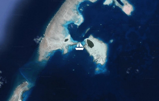
We are moored in the half-moon bay at Elato Atoll. We arrived yesterday after a 3 hour sail. When we arrived we went ashore for the usual island protocols. The Men's Lodge is where everything happens in this part of the Pacific. Women are not allowed in or near the lodge, except visitors. Most of the men and Chief John, arrived to greet us. They wanted to know where we were coming from, what we wanted to do on their island, and did we have any ability to help them with their broken tech, and did we have "weather". After a positive meeting (very nice people) we were granted permission to hike, dive, snorkle, etc. We can have a "village share" of the sea turtle, and the pig just prepared for a party today. We will delicately decline the turtle, but the pig is on our menu. These people are well educated, but love their traditional way of life. They share everything, even with total strangers like us. They do have some tech but it is only a spice, not the main course. Very few yachts call here, and those that do will find it a lifetime memory.
Departing Lamotrek Atoll for nearby Elato Atoll. Should arrive in a few hours.
Can't say enough good things about the people and hospitality of Lamotrek. Worth the effort if you are in the area.
Avg: 2.7knts
24hr: 64.9nm
We are moored in Lamotrek Atoll of Yap State. We had planned arrival this am in Elato Atoll, a bit farther west. The un-forecast higher beam winds and the EQ current, pushed us along nicely. We were safely able enter the pass here with good light yesterday afternoon. Ginger caught a nice wahoo on the way to the pass. We shared him with the locals on arrival.
Avg: 7.2knts
24hr: 173nm
70nm to Elato Atoll. Nice night of sailing, full main and genoa, Forecast winds of 6-8kts turned into 12-16kts on the beam. No rain with warm conditions, tee-shirt and shorts. Seas were a bit confused with swells from the SSW and NNE but all less than a meter.
Departed Puluwat Atoll at local noon today after the wind came up a bit. Lovely atoll with nice, welcoming folks living a very traditional life-style. No wifi or phone or power. Zoom in on GE too see the natural beauty. We are en-route to Elato Atoll which is a part of Yap State. 1-2 day trip in light air.
Avg: 6.3knts
24hr: 151.6nm
Arrived safely at Puluwat Atoll. Narrow entrance pass got the Admiral's attention. At one point only 6' from the beach. This is truly a postcard atoll.
Avg: 5.9knts
24hr: 141.5nm
Light air sailing leaving Chuuk, winds picked up around midnight, improving our speed. Wind and sea off the stern quarter. 42nm to Puluwat Atoll Pass. Sunrise in 45mins. AIWOB
Preparing to get underway this AM. Departing Chuuk for Puluwat Atoll 160nm to the west. Chuuk (Truk) has been a very pleasant surprise in regards the people and officials. All very friendly and helpful. We knew the diving was good and were not disappointed. Our diving was with the Truk Stop resort. Very Cruiser friendly folks, with an available mooring just off their dock. Highly Recommended.
Avg: 4.3knts
24hr: 104nm
Arrived safely yesterday here in Truk (Chuuk). Our anchor is is down in front of the Truk Stop Hotel/Dive Shop. Clearence was a breeze everyone very friendly. Heading to the US Post office for some waiting packages.
Avg: 5knts
24hr: 120.6nm
Quiet night broad-reaching and running in very light air, with some hours of motor-sailing. Seas relatively calm. 261nm to run to Chuuk NE Pass. All is well on board.
We didn't leave Ant Atoll yesterday, the wind went to near zero and the right on the nose of projected course, with numerous squalls. So we are now departing Ant Atoll in the next few hours with 10-12 knots from the SE with a mostly sunny day. It is great to have no schedule.
With the passing of Invest 92 (another GFS Ghost Storm) we are preparing to depart this beautiful atoll for Chuuk (Truk) Lagoon. There is a sunken Japanese fleet waiting for our underwater exploration.
We are anchored in idyllic Ant Atoll, in 4 meters over a beautiful white sand bottom. Ant is 28nm West of Pohnpei. Nice sail yesterday, after being anchored at Mangrove Bay Resort for nearly two months. Time to clean the bottom and replace the zincs.
We are preparing to raise anchor and clear out of Pohnpei this morning. A stop at the Mangrove Bay fuel dock for a top off, then on Ant Atoll 28nm to the west. We have been on this lovely, verdant island two months.
We arrived safely and cleared in yesterday after noon. Surprisingly, Pohnpei looks a bit like Bora Bora from the sea approach, with it's two granite peaks, one with a flat top. Well marked channel with a large commercial dock, we are anchored deep inside the bay next to Mangrove Marina and Hotel.
Avg: 7.6knts
24hr: 183.3nm
35nm to the North Pass of Pohnpei, afternoon arrival. Nice sailing conditions for us, one reef in the main and partial furl on the genoa. 2-3m swells aft of the beam pushing us along, too. All is well on board.
Avg: 5.6knts
24hr: 133.7nm
We are in route this morning heading for Pohnpei. OK night of sailing, winds not at the optimal angle, at our stern, but they have moved further forward, NE, giving us a decent sailing angle this morning. All is well on board.
Weighting anchor in a few minutes, heading for Pohnpei. Should be a two day sail if the winds are as predicted. We are both a bit sad to be leaving Kosrae. These are some of the nicest people we have ever met. The island is remote and beautiful, we were the only yacht here for 30 days in a large protected bay. This is "don't miss" place. FYI the Clearance process was fun and easy total of $50US arrival no departure fees at all.
Still anchored in Lelu Bay, Kosrae, FSM. Will clear out today for an AM departure tomorrow for Pohnpei.
Anchored in beautiful Kosrae at Lelu Bay. This bay is surrounded by green hills and mountains. It is reminiscent of the the Marquesas, except the anchorage is quite calm, not rolly or bumpy.
Avg: 5.6knts
24hr: 134.4nm
38nm to the entrance of Lelu harbor, Kosrae. 15mins to sunrise. Quiet night, light winds, motor-sailed to arrive daytime. 15 mins to sunrise. Looks to be a nice day with high, hazy, partial clouds and a beautiful sunrise. We'll roll out the code zero again after coffee, and drop our fishing lines in too, Mahi & Wahoo are running.
Avg: 4.5knts
24hr: 107.9nm
Winds largely single digits last 24+ hours. Slow but enjoyable sailing, seas calm, less than a half-meter. We haven't had a passage this slow in a few years. Enjoying the sunny days, no rain last 48hrs. We'll roll out the Code Zero today. All is well on board.
Avg: 5knts
24hr: 120nm
Pleasant if somewhat slow sail overnight. Winds were light and variable overnight from 3-14kts. Seas dropped to one meter mostly on the stern. Clear skies w/bright moon. Good first night after so long in the lagoon.
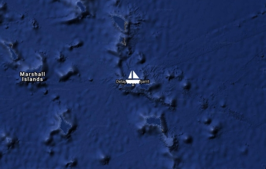
Just pulling the anchor up now here in Ebeye, we'll cross the lagoon and exit the South Pass. Then take a direct course for Kosrae. 2-3 days depending on winds.
Preparing to leave the Kwajalein Marina for the anchorage at Ebeye this morning. We must officially clear out of the Marshall Islands with C & I located there. Great send-off party on board last night! Thanks!
We are underway inside the Kwajalein Atoll. Sailing between Roi-Namur Island and Kwajalein Island, where we expect to linger until departing for Kosrae in the FSM. Our friend and Kwaj sponser "Mo" is at the helm and apparently enjoying sailing a catamaran. Will her mono hull ever be the same? Mixed bag of weather rain and sun. Afternoon arrival at the Kwaj Marina expected.
Watch out for the convergence
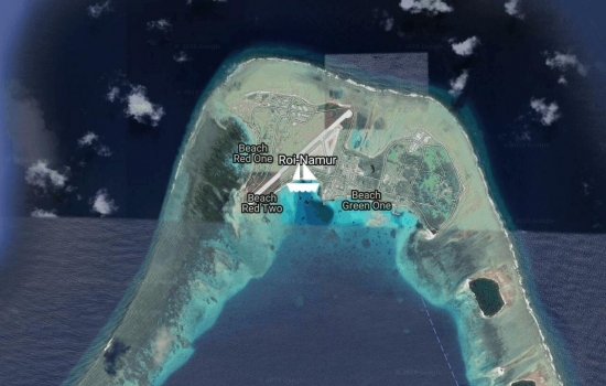
Still anchored at Roi-Namur. Enjoying the Holidays at the USAKA Base.
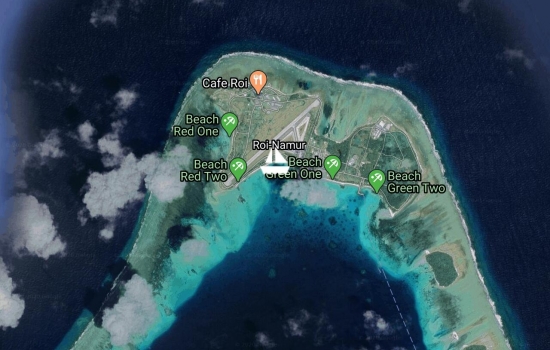
Anchored at Roi-Namur off Red Beach at the US Army Base. The storm forecasted for the northern Marshall Islands is upon us. We are glad we made the trip down from Rongerik where there is little protection to this more protected place. The storm is passing us well to the east, so we so we are not getting it's full force. We are in the lee of the Kwajelain Atoll with winds overnight to 45kts here. Anchored in deep white sand with good holding. We have anchored here several times before on our previous visits to the base. s/v Apolima is in sight anchored 2.5nm south of us at "3rd" Island and is doing fine. We expect the storm to move past us later today on its way to Rongelap/Rongerik Atolls. All is well aboard.
Avg: 6.1knts
24hr: 146.2nm
12nm to the North Pass of Kwajalein Atoll. Sunrise in a few minutes. Clear, moonless night passage with 3m swells just aft of the beam, steady winds to 18-22 g28. We will proceed into the lagoon with good light in 2 hours. We have s/v Apolima 1nm from our beam, also heading to Kwajalein.
Preparing to get underway. Planning to leave Beautiful and Isolated Rongerik Atoll for Kwajalein Atoll, in the next few hours. An overnight sail to the North Pass of Kwajalein Atoll.
Anchored in Rongerik Atoll, completely un-inhabited, 20 islands make up this lagoon. Most with white powder beaches and coconut palms. Every shade of Turquoise surrounds us. Paradise found.
10nm miles from the South Pass of Rongerik Atoll. Nice overnight passage from Likiep Atoll. Sunrise in a few minutes, we'll proceed into the pass with good light. We passed s/v Apolima yesterday evening on this same heading; not currently in visual or radar range.
Avg: 8.9knts
24hr: 213.9nm
Nice fast passage from Majuro consistent wind in the high teens, moderate seas. We are 14nm from the south pass of Likiep Atoll, ETA 8:45am or 20:45Z.
Leaving Majuro for what could be the last time. We are heading for Likiep Atoll to spend a few months in the northern Marshalls, departing for FSM after the New Year. Christmas in Kwajalein. All plans written in "Sand Script"
Motoring on a glassy lagoon from Eneko Island to Majuro. We spent the week diving, snorkeling, beach fun, as well as boat projects, anchored off this small day resort. Water temps as high as 36c at the surface, vis at 30+m.
Moved to Taroa Island On Maleolap Atoll. Going to dive the WW2 wreck of the Terashima Maru this morning. Still have these these unusual westerly winds, thankfully the are light or the fetch would be very uncomfortable.
Anchored at Airik Island, Maleolap Atoll. Yet another warm and sunny day. New solar panels are keeping far ahead of our power consumption, even with two visitors on board (Gingers parents). Haven't run the gen-set in since the solar installation except to make water.
Moored at Enemonet Island in the Majuro Lagoon. Enjoying this lovely calm bay doing some boat maintenance. Preparing for the arrival of our new solar panels. 1300 watts worth!
Preparing to depart our Majuro Mooring for the Enigu Island. Lagoon very choppy with West Winds.
On our mooring in Majuro. Yachties Night Out at the MIR last night, Team s/v Seal & Viadante took the cash at Quiz night. The US Post Office was glad to see us yesterday, to free up some shelf space where our packages were being stored. All well on board.
Avg: 5.7knts
24hr: 136.7nm
sp: 7.2 24NM miles to run to Majuro Pass. Overcast and light rain falling. Too cloudy for the Meteor Shower.
Departed Kwajalein Atoll, last evening for Majuro Atoll 151nm to run. Lumpy conditions with variable wind speeds. All is well on board
Enjoying the US Base hospitality here on Kwajalein on the guest dock. INVEST 96 is going over us at the moment. We'll head south to Majuro with any wind from the NE in the coming week.
Arrived Kajalein Yacht Club yesterday afternoon. We are resting comfortably on the guest dock, first dock since Apia in 2016! This REALLY is an American Town. We'll enjoy the change for a week or so before heading to Majuro.
Preparing to raise the anchor. Departing Roi-Namur Island for Kwajalein Island. 42nm run all inside the Kwajalein Atoll. (the worlds largest)
Anchored at Roi-Namur Island on Kwajalein. We are enjoying the hospitality of the US military base here. Thanks to our sponsors, we have full access to all the base facilities. We'll get caught up on wifi (first wifi in 3months!!!) in the next few days. We have loaner bikes, we haven't ridden bikes in several years good to be back on the road!
Avg: 7.7knts
24hr: 183.9nm
Just after sunrise and 10nm miles from the north pass of Kwajalein, heading for the US Base at Roi-Namur, just east of the pass. Wind shifted to the SE this morning!
Just leaving Tufa Island, Rongelap for Roi-Namur, Kwajalein. Nice afternoon for a sail. This is an overnight passage hopefully timed to arrive at the north pass of Kwaj after sunrise.
Moved inside Rongelap Lagoon to this gorgeous nearly 360 protected anchorage: Tufa Island. Mark1 eyeball nav the last nm. White sand beaches with lots of coconuts and beautiful reefs & bommies. This may be paradise found. Caught a Rainbow Runner on the way over! No one lives in this paradise, hard to believe. NASA rocket launch tonight from Kwajalein, should have excellent seats.
Moved inside the lagoon to Rongelap Island, the main habitation for this atoll. Anchored off the municipal dock. Population about 30-40 workers building new homes for the former displaced inhabitants. A modern ghost town, complete with an empty resort, wonderful concrete roads and paved airport with new terminal, (but no air service) 24/7 electricity (free) and RO water (free).
Anchored Laboredj Island on Rongelap Atoll.
Underway Rongerik Atoll to Rongelap Atoll.
Avg: 7.8knts
24hr: 188.3nm
sp: 7.8 Timing our arrival for light at the south pass of Rongerik Atoll. Just now sunrise with 8nm to run.
Underway from Likiep Atoll to Rongerik Atoll

We are anchored on the deserted island of Enej in the Likiep Atoll.
Anchored in Likiep, unique village here settled by Europeans in the 1890s. We are enjoying this lovely quiet bay with winds outside at 23kts and 2.5m seas. Just gifted with 4 dozen cay limes and 20 drinking nuts: Sundowners!
Inroute Wotje Atoll to Likiep Atoll
Still in the Wotje Atoll but moved north to beautiful Ormed Island. Its one of those places with blazing white sand beaches and every shade of turquoise water.
Anchored off the old Japanese Seaplane ramp, Wotje, RMI. Beautiful calm anchorage here. Sunken ships and aircraft in the lagoon. Japanese bunkers, aircraft and war relics abound on shore. Great place for divers and history buffs.
Slowing making our way thru the atoll in the predawn moonlight to the NW Pass of Maloelap Atoll, enroute to Wotje Atoll.
Anchored off the old Japanese Pier at Taroa, Maleolap.
Avg: 6.9knts
24hr: 166.8nm
6nm miles from the Enijun Pass of Maleolap. Sun is just up. Squally night early, later cleared. Looks to be a nice mostly sunny day.
Underway tonight for Maleolap Atoll, just departed the Majuro. Plan to arrive after dawn at Maleolap south pass. Rendevous with Blowin' Bubbles & Halo.
Moored at Enigu Island. Contrary winds, Numerous Squalls, decided for us to hang around Majuro Lagoon for another day, before departing for Maleolap. The ITCZ is over us making the weather even less predictable than usual.
Moored at Anememwot, Majuro Lagoon. Preparing to get underway for Maleolap, overnight passage tonight.
Moored at Majuro in the Marshal Islands. BIG Whole Island New Years Eve street party tonight ashore.
Avg: 2.6knts
24hr: 61.7nm
Arrived safely in Majuro yesterday evening, after an amazingly nice and fast 6 day/1100nm sail from Tuvalu. We've taken a mooring in the South Anchorage; our friends on sv Seal welcomed us back home! It's likely we will be here through the Holidays.
Avg: 8.6knts
24hr: 206.4nm
Nice night with a few squalls around midnight, brilliant moon overhead, setting just at sunrise. We are smelling the barn, 55nm to Fordyce Passage on the east end of Majuro.
Avg: 8.5knts
24hr: 204.1nm
Great warm night of sailing. Gentile flat, following sea, consistent breeze of 15-18kts. Nearly full moon, clear skies. Just now local sunrise, hopefully another good day ahead. 210 to run to Majuro, Marshall Islands
Avg: 8.3knts
24hr: 198.8nm
We are back in the Northern Hemisphere! Crossed the equator again, 4th crossing in 2 years. 55 nm to Tarawa, however if the weather to the north looks good we will press on to Majuro in the Marshalls, if not we'll hang in Tarawa to wait for the window. Yachts ahead of us are reporting the Kiribatis are not issuing permits to the outer islands including Makin (Butaritari) island, sadly we will pass right by it on our way to the Marshalls.
Avg: 8.7knts
24hr: 209.5nm
Nice night of sailing, beautiful sunrise this morning. 230 to run to Tarawa.
We now have 7 yachts on our net, all moving north thru or to the Kiribatis & the Marshals. and expect a few more to join in the next few days. 8122 or 8297 at 1845Z & 0700Z
Avg: 7.7knts
24hr: 184.1nm
410nm to run to Tarawa. Just after sunrise getting ready to take the overnight reefs outs.
Avg: 6.8knts
24hr: 162.2nm
Beautiful morning. Overnight reefs out at sunrise, back up to speed. Steady progress to Tarawa 565nm to run
Departing Funafuti this morning for Tarawa
sv Chez Nous joined us in Funafala, Tuvalu. We are planning a Monday Departure for Tarawa.
Anchored Funafuti w/ 6 other north-bound yachts. FYI Funafuti is currently not allowing transiting yachts to stop at any other islands in the group including Namumea or Nukufetau.
Avg: 6.1knts
24hr: 146.6nm
Funafuti lagoon! Just entered the pass headed for the anchorage and clearance. Beautiful sunny day. 8 yachts already anchored here, several more inbound, guess the secret is out. Previous 2 times we were here, we were the only yacht for months!
Avg: 5.8knts
24hr: 138.4nm
Warm & mostly sunny, with occasional light showers. Winds light. Quiet starry night with lots of meteors. Past close Niulakita a few hours ago; need to stop there one of these trips saw lights ashore. Need to adjust speed to arrive at the South Pass of Funafuti at first light tomorrow.
Avg: 6.4knts
24hr: 152.4nm
Beautiful sunny morning. We had a great starry-night sail, warm & clear, nearly flat sea, consistent beam winds.
Avg: 5.8knts
24hr: 138.6nm
Sailing around numerous rain cells, leveraging off their outflow. 376nm to Funafuti
Just Departed Viani Bay for Funafuti, Tuvalu. ETA Friday AM. Motorsailing this morning in the shadow of Teveuni.
Departed Savusavu heading north via the Somosomo Strait. Motorsailing in light air in company with s/v Rouser.
Savusavu. Moored at Copra Shed Marina. Preparing the final items for a departure from Fiji, headed north. Possible Sunday or Monday departure.
Savusavu, moored at Copra Shed Marina.
Savusavu. INTERESTING passage yesterday from Nabouwalu (Coconut Point). Started motoring with 2.5 kts seas calm, with intermittent light showers. After some hours we approached Nasonisoni Pass and the winds jumped to 22kts ESE, by the time we through the pass we had sustained winds of 38-42kts, g45. Seas were still under 2m, thankfully they hadn’t had time to build. Showers remained intermittent the whole day. Strangely were not behind any islands at all to have blocked the wind, our entire route was open to the E. Other sailors approaching from Teveuni saw 47 kts.
All in a days sail, safe and sound here in a very quiet Savusavu.
Motorsailing in light rain from Coconut Point to Savusavu. Landed a Tuna, & a Barracuda yesterday on our passage across the Vatu-I-Ra channel. Released the 'cuda. The third strike on the same lure, (a yellow painted plug), spit it out no idea what it was. The neon yellow squid on the other line had no takers.
Anchored at Volivoli Resort last night. We will depart for Vanua Levu via Vatu-I-Rai Pass and Blight Water this AM.
Motorsailing in light air towards Rakiraki, Viti Levu.
Turning NORTH this morning on our slow way to the Marshals, via N. Fiji, Wallis, Tuvalu & Kirbati. Departing Denarau first stop today Lautoka.
On a mooring for a few days in Denarau Marina.
Back in the water! Splashed at Vuda yesterday and sailed to Saweni Bay where we are anchored and attempting to rid our boat of multi-colored yard dust & dirt!
We watched the area Diwali fireworks from our bimini temporarily 15m above sea level. Great view with dozens of local sites putting on displays. Still in Vuda Marina, nearly ready to go back in the water, with new bottom paint.
Vuda Marina, on the hard for a bottom painting.
In Vuda Marina, awaiting haul out for new bottom paint.
Beautiful sunny day anchored in Saweni Bay. Ginger's parents depart today ending their month-long visit with us.
Avg: 3.9knts
24hr: 92.8nm
Sailing to Saweni Bay, Beautiful sunny day. Four lines in the water!
Anchored at Cuvu Bay for another try at the Mantas.
Anchored in the Blue Lagoon
Anchored Somosomo Bay, Naviti Island. 30 kts gusts early last evening.
Anchored at Cuvu Bay to dive with the mantas. Near the pass at Manta Resort.
Saweni Bay, preparing to hoist the anchor for Manta Ray Bay.
Still Anchored Saweni Bay. Mangos are just coming into season, the pickling type have arrived but the sweet eating types any day now!
Moored in Denarau Marina.
Anchored Musket Cove for Regatta.
Anchored in Musket Cove for the Regatta.
Anchored Musket Cove for the Regatta!
Anchored Saweni Bay.
Gorgeous Sunny Morning in Saweni Bay, only a bit of smoke & ash from the sugar cane fields being burned off.
Anchored Saweni Bay just north of Vuda Marina.
Avg: 3.7knts
24hr: 89.4nm
Sailing to Vuda Marina. Just passing Likuri Harbor on SW corner of Viti Levu.
Anchored at Vanisea, Kadavu. Will depart for Vuda Marina this afternoon or tomorrow afternoon if wind fills in.
Anchored at Vunisea, Just off the Kadavu Airport.
Anchored Talualia Bay, west side of Kadavu, very rolly. This is just an overnight stop heading to Vunisea, Kadavu in a a few hours as visibility improves with sun moving higher.
Heading for the west end of Kadavu.
Anchored in Soso Bay, South side of Kadavu. Planning to dive with the giant mantas today, hopefully they cooperate by showing up!
Anchored at Korolevu Bay, Kandavu. 2nm from Matava Dive Resort.
Anchored off Matasawalalevu (near Niagoro Pass) NE corner of Kadavu. Planning to dive pass today.
Anchored in Kavala Bay, Kadavu. Beautiful deep bay only open to the north. Lush green hills surround the bay. Wind 5kts S, Sea 1m SSE, Bar 1014, Clouds multi level 100%, Rain intermittent, heavy at times.
Anchored Ono, Kadavu
Just underway at Beqa heading for Kadavu. Nice morning, sun is out! Wind 15E, Sea 1m SSE, Bar 1017, Clouds 40%
We are anchored at Malumu Bay, Beqa in a deep fiord-like bay. Winds gusting overhead but calm here at sea level.
Wind 7kts g 15kt SSE, Clouds 90%, Bar 1019, Trace Rain last 24
Reaching to Beqa from Suva. Beautiful sunny day. Wind 14kts forward of the beam.
Arrived Suva Harbor after motor-sailing in very light air all the way from Gau island, yesterday. Today Suva is beautifully SUNNY (hard to believe in the rainiest harbor in the S.PAC)! Wind 7kts NE, Sea: 1m SE, Clouds 5%, Bar 1018 steady, 0 rain last 24h
Underway, Gau Island to Suva. Wind 10kts ESE, Sea .25m, Clouds 90% high overcast, Bar 1018, trace rain last 24h.
Beautiful cool day in Herald Bay, Gau Island. We'll move a bit south to dive Nigali Pass, Gau, today.
Wind 11.5kts SE, Sea 1m SSE, Bar 1017 steady, Clouds 40%, 0 Rain last 24h, Air temp 20c
Anchored Gau Island, visited by a giant manta ray while anchoring.
Wind 12kts SE, Sea 1m SSE, Clouds 10%, large band to our north, Bar 1017, No Precip last 24h
sp: 6 d: 27/07/17 06:58 UTC Just departing Koro Is. for Gau Is. In company with Blowin' Bubbles.
Wind: 13 kts SE, Sea: 1m SSE, Bar: 1018, Clouds: 40%, Quite chilly 21c, no precip last 24h
Anchored Dere Bay Koro Island, Fiji. Waiting for wind to depart to Gau Island.
Wind 8.5 S; Sea 1m SSE; Bar 1017; Clouds 50%.
Moored in the beautiful Dere Bay, Koro Island. Nice diving and friendly Expat community. Quiet calm bay. Repaired two Winston damaged moorings, with Blowin' Bubbles, now useable by yachies, without charge. Wind 3kts E, Seas calm, Clouds 10%, Bar 1014 steady, light shower early am moved to the west. Beautiful sunny day.
Anchored in Dere Bay, Koro Island.
Paradise Taveuni Bay, Just getting underway for Koro Island.
Wind 2kts E, Seas calm behind Taveuni, Clouds 20%, Bar 1016,
Moored at Paradise Resort, Taveuni.
Wind 13 E, Sea 1 m SE, Bar 1019 rising, Clouds 30%, no precip last 12 hours, cool temps overnight 16c.
Viani Bay, diving the walls off Taveuni daily!
Wind: 8 kts NE; Sea 1m SE; Cloud 10%, Bar 1014
Diving the reefs between Viani Bay & Taveuni this morning. Anchored in Viani Bay, Vanua Levu. Wind: 14kts SSW; Sea: 1.25m SE; Bar:1015 steady; Clouds: 70%;
d: 30/06/17 06:49 UTC Anchored in Viani Bay next to s/v Blow'in Bubbles. Beautiful cool calm morning here in the bay, sunrise on the misty mountain top of Teveuni in the distance.
Wind: 8kts SE; Sea: 1m SSE; Bar:1015 steady; Clouds 50%; no precip. Temp 22c
d: 29/06/17 06:50 UTC Anchored at the Cousteau Resort, Vanua Levu. We'll be underway for Viani Bay within the hour. Wind: 12kt SE; Sea: 1m SSE; Bar: 1016 steady; Clouds: 100%; light rain showers in the area. Temp 23C
d: 24/06/17 06:59 UTC Moored in Savusavu. Still provisioning. Beautiful calm morning no rain last 36 hours. Glassy bay. Wind: 1kt SE; Sea calm; Bar; 1011 -1; Clouds 65%; No precip last 36 hours.
Anchored in Savusavu. Beautiful clam morning on absolute glass on the river. Wind less than one knot.
Avg: 3.5knts
24hr: 82.8nm
Anchored Safely in Viani Bay last night, heading around to Savusavu after sunrise.
Avg: 5.2knts
24hr: 125.9nm
d: 13/06/17 06:33 UTC Just north & east of Cikobia Island, Fiji. Heading for Rabi and Somosomo Channels to Savusavu. Sailing under 50% furled genoa & single reef main. Seas 2m with random sets 4m last night. WET. All is well on board.
wind: 20.5kts ESE; Sea; 2m SE; Bar: 1017; Clouds 85%, vis 10nm; no rain
Avg: 5.5knts
24hr: 132.9nm
d: 12/06/17 06:50 UTC On a heading to approach the Somosomo Straits from the NE. 125nm to Somosomo Strait.
Avg: 5.3knts
24hr: 127.1nm
d: 11/06/17 07:02 UTC Motorsailing with very light winds. Calm seas, nearly cloudless skies. Brilliant full moon last two nights. Boated a tuna each of last two days. Sashimi!
Avg: 5.4knts
24hr: 129.5nm
d: 10/06/17 06:38 UTC Underway for SavuSavu, Motorsailing, calm seas. Spectacular full moon set and sunrise this morning on a glassy sea.
Departing Funafuti this morning for SavuSavu.
d: 08/06/17 06:43 UTC Anchored Funafuti, fueled up and ready for departure to Savu Savu tomorrow.
Happy Sailing, you two! We're
d: 07/06/17 07:16 UTC Anchored Funafuti, only yacht in Tuvalu. Quite hot ashore, bay is glassy calm. Fueling today, then ready to proceed Wallis or Suva Suva with any suitable wind.
Avg: 4.7knts
24hr: 113.3nm
d: 06/06/17 06:48 UTC Slowly motoring to time the entrance to North Funafuti Pass. 6nm out. Seas calm, 1/2 hour after sunrise, winds very light. Slack tide in 30 mins. All is well on board.
Avg: 6knts
24hr: 144.1nm
d: 05/06/17 06:44 UTC Beautiful, warm, sunny day, seas flat, winds under 10kts. Motorsailing. 100nm to run to Funafuti.
Avg: 5.2knts
24hr: 125.2nm
d: 04/06/17 06:51 UTC 220nm to Funafuti. Sky 90% overcast. Very widely scattered low-energy squalls in the area. Sea less than a meter. Winds have slowly clocked 360+ in the last 24 hours. All is well on board.
Avg: 5.3knts
24hr: 127.4nm
d: 03/06/17 06:53 UTC Overcast, broad area of rain ahead. We'll try to pick our way thru, although we do need a good rinse.
Avg: 6.2knts
24hr: 149.2nm
d: 02/06/17 06:49 UTC Yes, we have been able to hear GHR, not sure they could hear us w/o a relay. Winds light after 0300, flat seas, clear, warm & sunny day. Beautiful sunrise.
Avg: 7knts
24hr: 168.3nm
d: 01/06/17 06:50 UTC New Destination: FunaFuti. Winds picked up overnight. Still in night sail mode: 1 reef main. We would like to get the most SEasting before it lightens up further south. Few scattered low energy squalls in the area, with little moisture. Another warm sunny day!
Avg: 6.5knts
24hr: 155.3nm
Light winds, calm seas, clear sunny skies. Motorsailing off & on with genoa & main lightly pulling. We are in the lee of Tarawa Atoll now. On course for the Tarawa Main Channel marker less than 20nm. Good chance we will bypass Tarawa and press on to Tuvalu.
Avg: 5.6knts
24hr: 134.6nm
d: 30/05/17 07:02 UTC Calm & slow night, wind speeds under 8kts for 8 hours. Back to speed now. Full Genoa & 1 reef main. All is well on board, meet lines in the water at sunrise.
Avg: 9.2knts
24hr: 219.6nm
d: 29/05/17 07:16 UTC South bound from Majuro. Hot and sunny light breeze. Thinking of changing headsail to code zero.
d: 28/05/17 14:14 UTC Departing Majuro for Fiji, heading generally SE towards Kiribati. Lovely day. Fishing lines out yahoo are biting.
d: 08/05/17 07:18 UTC Preparing to depart Amamenot Island for Majuro harbour. Beautiful day!
Avg: 2.9knts
24hr: 70.7nm
Back in Majuro Atoll, moored at beautiful Anemwanot island.
Avg: 4.8knts
24hr: 115.5nm
40nm to run to Majuro Pass. Motorsailing.
Underway Kwajalein to Majuro.
Anchored Ebeye Island, Kwajalein Atoll.
Enroute Roi-Numur to Ebeye Island inside the Kwajalein Lagoon. 30 miles of reach on flat water, beautiful sunny day. Week four with no measurable rain in the North Marshals.
Anchored at Roi Namur, Kwajalein, the US Radar/Missile test facility.
3nm from the the North Pass of Kwajalein Atoll. Massive radar dishes & Airport visible on Roi Manur Island.
Anchored Rongelap Island, Rongelap Atoll
Anchored at Eniaetok Island, Rongelap Atoll. Yet another deserted beautiful island.
Arrived Rongelap Atoll yesterday pm. Pleasant downwind/wave sail from Rongerik with 20-24kt winds and 3m swells. Anchored at Labavedj Island, just north of the NE Pass. This is as far north as we will go this season, turning south from here.
d: 03/04/17 08:51 UTC Underway Rongerik Atoll to Rongelap Atoll. 25nm to run
Anchored Rongerik Atoll. It is a gorgeous and wild place, totally uninhabited. Not a light or dwelling in sight.
Avg: 6.3knts
24hr: 151.9nm
sp: 6.2 28mn to run for Rongerik Atoll
Anchored Kaven Islet, Ailuk Atoll, preparing to depart for Rongerik Atoll this morning.
Anchored safely at Uriga Island, Ailuk Atoll. Arrived yesterday morning.
Heading for Ailuk Atoll, Marshall Islands. Sun is now up, just tacked east direct to the pass. 10nm to the pass.
Anchored at Wotje Island, Wojte Atoll, just off the old Japanese Sea Plane Ramp.
Following you on YIT.
Just entering Wotje Atoll Pass. Beautiful Sunrise!
Anchored Ollot Island, Maloelap Atoll.
Anchored off Taroa, Maleolap Atoll.
We are anchored off Airik Island in the south Maleolap Atoll. Hot and Sunny with crystal clear water, can easily see the anchor in 12m.
We are in the channel between Aur and Maloelap atolls, 13 miles to the Maloelap south pass.
Moored at beautiful Anemwanot. Nice wreck dive here at these coordinates and deserted white sand beaches. Preparing to depart for the Maleolap Atoll tonight.
Moored Majuro, Marshal Islands, arrived safely yesterday afternoon. Hugh lagoon!
Avg: 7.9knts
24hr: 189.1nm
20 nm to run to eastern tip of Majuro Atoll. 50% Genoa & 1 reef in main. Easterly seas confused swells under 2m. Caught a tuna! shashimi dinner last night. Cats too!
Avg: 6.3knts
24hr: 150.7nm
On a direct course to Majuro. Reaching in easterly trades which finally filled in 2 hours ago. Beautiful day!
Departed Tarawa for Majuro, Marshal Islands.
Anchored and Cleared into Tarawa yesterday AM. Going exploring today.
Avg: 6.1knts
24hr: 146.7nm
Arrived Tarawa, standing off waiting for sunrise/ good light to approach the entrance.
Avg: 6.8knts
24hr: 164nm
Slowing down to time our arrival Tarawa in good light tomorrow AM. Crossing the Equator in a few minutes. Will celebrate with a Cafe au Lait. Cheers! (Resend)
Avg: 7.1knts
24hr: 170.7nm
d: 07/01/17 06:54 UTC Slowing down to arrive Tarawa in good light AM tomorrow. Crossing the Equator in a few minutes will celebrate with a cafe au lait.
Avg: 6.3knts
24hr: 151.8nm
d: 06/01/17 06:55 UTC In Kiribati waters now. 270nm to run to Tarawa. Winds out of the east, seas flat, sunny day, lines in the water.
Avg: 7.2knts
24hr: 171.9nm
Enroute Nukufetau to Tarawa
Avg: 6.9knts
24hr: 166.7nm
Enroute from Nukufetau to Tarawa.
Departed Nukufetau, Tuvalu @ 13:00, heading for Tarawa, Kiribati. Possible intermediate stop at Nanumea, Tuvalu.
d: 26/12/16 10:11 UTC Happy Boxing Day. Arrived Christmas morning here at beautiful Nukutefau Atoll, Tuvalu. Great Christmas celebration last night with s/v White Hawk.
sp: 6.2 MERRY CHRISTMAS!
Arrived yesterday afternoon. Anchored in Funafuti, Tuvalu, off the town seaside park, which is all decked out for this week's Christmas events. Beautiful lights and local music last night.
Avg: 6.5knts
24hr: 156.7nm
d: 22/12/16 05:42 UTC Motor-sailing in flat sea, 48nm to SE pass of Funafuti. Crossed the 180th meridian, we are now EAST. A glass of bubbly later to celebrate!
Avg: 6.1knts
24hr: 146.8nm
180nm to run to Funafuti, Tuvalu
Avg: 6.2knts
24hr: 148.5nm
d: 20/12/16 07:15 GMT+1400 Light winds, calm seas, sailing and motor sailing.
Avg: 6.5knts
24hr: 155.5nm
Motor Sailing on calm seas heading for Funafuti, Tuvalu
Underway Apia to Funafuti
In the Apia Marina.
<p>Hope you are not too
Avg: 4.8knts
24hr: 114nm
Sailing along North Coast of Western Samoa 15 miles to Apia.
Departing Pago Pago for Apia
Anchored in Pago Pago Harbor.
Avg: 1061.3knts
24hr: 25472nm
Approaching Pago Pago Harbor Entrance. 20nm to run.
Avg: 7.2knts
24hr: 172.3nm
Enroute from Neiafu to Pago Pago.
Outbound Vava'u for Pago Pago
Moored in Port Maurelle
No blogs available for this yacht.