PAWS
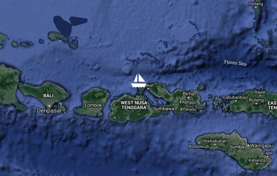
Gull winged sail from Satonda to Moyo Island today on the north side of Sumbawa. Anchored on W coast opp Labuhan Aji Village in 32m sand rubble bottom.
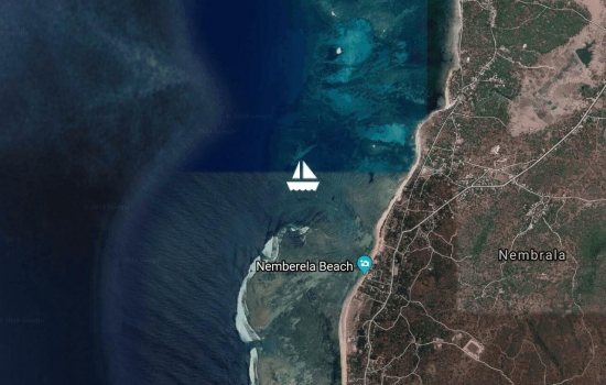
Arrived at Nemberala on Rotes SW coast where the T land surf break is. Big swell and windy anchorage.
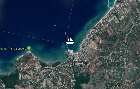
Sailed from Semau anchorage W of Kupang to Ba?a Harbour on N coast Rote today. Winds dropped off in the arvo. Anchored close to town E of the ferry pier
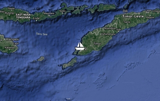
Arrived Kupang, capital of W Timor after a 7 day journey from Banda with overnight stopovers at W coast Wetar & N coast Timor to break up the 589 nm distance.
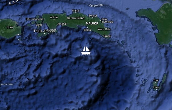
We have made the passage from Sorong to Banda Neira through rough seas, high winds & opposing currents. Arrival into the bay with volcanic scenery & dripping green hills with a friendly community eager to make our stay unforgettable. Already in love with this place
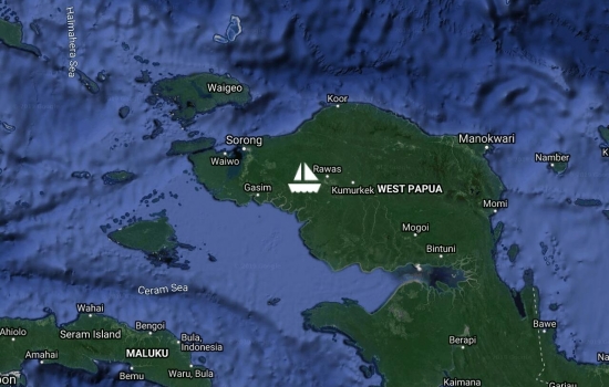
Paws has left Sorong and heading south. Completed Selat Sele passage today catching the tide, and anchored behind Pulau Lugo in the exit to await morning for navigating nearby shoals.
This plot puts you up a creek
Epic sail from Penemu to NW side of Fam yesterday. Anchored on a 3m patch of sand next to a pretty white beach & Ambabee island behind. And the best bit- having a fire & no bullshit. Simple life
Looks perfick. Glad you've
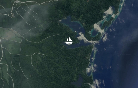
Tied fore & aft across Penemu fiord, Raja Ampat with vertical limestone walls & 50 metres depth. What a backdrop & what a challenging yet crazy experience! Still catching my breath.
Just read about Raja Ampat
It looks amazing! What an

Raja Ampat. We left Waisai on Waigeo 2 days ago. The anchorages we have found with satellite image mostly don?t have names. But we are between Waigeo and Gam islands surrounded by jungle laden limestone casts
Looks like only you, jungle,
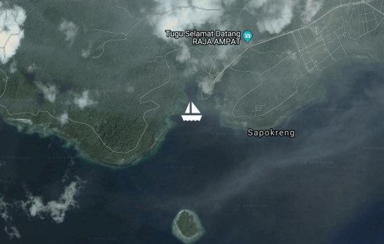
Waiwo Bay anchorage in Waisai- officially in the Raja Ampat archipelago! Arrived yest, got our permits, dive regs serviced & off we go! This has been a long awaited bucket list destination.
Enjoy exploring the wonders
Sounds like your dreams are
Avg: 5.1knts
24hr: 122.7nm
Arrived in Sorong, anchored at Doom Isl. Adverse current for 70nm- hard going for final leg.
Left Padaido Islands at 0630 this morning. Position as of 1245. Assisting current of 3 knots. 7nm S of Biak heading W under full sail.
Love the fact that you are
Confused this end. According
Departed Biak and motored 25 miles SE to the Padaido island group.
Anchored at Pulau Nusi for some white sand, blue water, green foliage and quiet time.
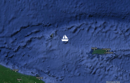
Arrived Biak Indonesia after 5 days 5 nights passage from PNG. Very light downwind run. We finally made it.
Congratulations! You and Paws
Avg: 4.3knts
24hr: 102.1nm
conditions still very light. Mostly able to keep the kite filled & travelling at 3 knots. Now 43 miles from Biak. If the wind holds we will arrive tomorrow morning. Stopped for a swim at lunch time when the wind died briefly. OMG how refreshing!
A much better run for you and
Avg: 3.2knts
24hr: 77.9nm
Under headsail only as broad reach/ downwind. Now holding 3.5 knots. 130nm from Biak
A better 24 hrs albeit with
Another light day at sea- some drifting some sailing. Average speed 2.5 knots. 200 nm from Biak. Hot on the equator! (Well 90 miles from it) Lots of bucket showers being had.
Looking at Windy, conditions
Easterly change very slow to come. Forecast keeps pushing it back a day, daily. Able to fly the kite for a few hours today now poled out the jib but very slow going. At this rate will arrive in Biak in 3.5 days time!
Progress of sorts. Willing a
Departed Vanimo PNG this am now in Indonesian waters. East wind still kicking it?s heels, motored most of day but it?s started to swing this eve.
Looks like the Easterlies are
Such a shame you had to motor
Arrived into Dakriro Bay, Vanimo yesterday- the last border town of PNG before Indo. A gruelling upwind sail from Ninigo but we are in one piece (ish) & have caught up on sleep. Await the easterly winds to take us to Indo...
Great work! Rest up & repair!
50nm from Vanimo now. Period of no wind after storm passed so motored for 3 hours then came back in giving us the angle for one tack. Hope it holds as much set drift & leeway. Currently sailing at a good 5 knots
Fingers crossed for the one
Avg: 3.7knts
24hr: 89.8nm
Tacking our way to Vanimo. About half way as of 1600 today. Slow going with patched double reefed main & damaged daggerboard. Paws is limping heroically & taking it all better than us. Weather lightened through day. Hoping for an easier night.
Following your progress both
Hope you and Paws have an

Departed Longan in Ninigo bound for Vanimo with the only wind of the foreseeable future. Wish we could have stayed longer. 2nd attempt as had to double back yest to repair torn main sail. Sailing as gently as possible now
Fingers crossed for the sail
Arrived at Ninigo islands. Anchored beside Bahamas. Received a wonderfully warm welcome from the Longan villagers in their sailing canoe with gift of fish
WONDERFUL TO CONTINUE TO MEET
Went for an explore past Maron, Tatahau and Mono islands and anchored at NW entrance for the afternoon. Then departed Hermits 1800 bound for Ninigo
Wishing you safe sailing and
Tucked in behind Akib Island next to Manta Pass. 2 to 3m sand bottom. Hiding from this blow for the next few days. No sign of easterly change anymore
Moved to Bird Island inside the SW edge of the lagoon. There is a tern and boobie rookery here and a shallow reef edge to the outer drop off.
Looks beautiful, and
Avg: 2.9knts
24hr: 69.3nm
Arrived at Hermit Islands PNG. Visited village at Luff & anchored at Manta Pass. Met Bob the Manta Guardian. Wow what a magic spot. SO remote.
Enjoy exploring! L & J xo
Avg: 409.9knts
24hr: 9836.7nm
Running kite downwind most of day. Picked up a little strength this eve from an oncoming storm. Now full main & jib up beam reach. 58 miles east of Hermit islands, our first destination
Avg: 428knts
24hr: 10271.2nm
MPS sail most of day. Took down before a 25 kn storm. Riding its tail now & passing the north of Manus to cont on to Hermits.
Sail safe Sail free. Here's
Avg: 3.6knts
24hr: 86.6nm
Flew the MPS kite most of the day with light downwind run. Now nothing- glass out drifting and swimming towards sunset
Sailing under headsail only downwind at 3.3 knots with assisting current. 6 nm north of New Hanover heading west
We wish you good winds for
Checked our of Kavieng today heading west. Anchored in Senta Passage on N top of Patio Island, New Hanover
Escaped Kavieng again for long weekend. At Lissenung Island. Cute resort & lovely house reef with lots of fish (hallelujah) -protected zone...
Motored to Nusalomon Isl to get away from town for a few days & check out some local islands. Sand & reef anchorage with white beaches & small village
2 day 2 night passage to Kavieng from Rabaul 194 nm travelled. Anchored at Nusalik Isl opp main town
Arrived Rabaul PNG 0800 27 March after a challenging passage. Strong adverse current & head winds through all of the channel. Anchored opposite the Yacht Club awaiting clearance. Email didn?t send hence the late post.
Hi Loves. Safely anchored
Avg: 3.6knts
24hr: 86.5nm
Tacking between storm systems all night. Very confused lumpy sea so slow speeds. 80nm to Rabaul but journey likely 130nm with wind angle
What a slog! Hope conditions
Nearly there. I know there's
Avg: 3.4knts
24hr: 81.4nm
Sailing cautiously when we can. Wish we?d waited for a better window to go! Much sailing changing & too much diesel used. Still 87nm from St George?s channel entrance
Slowly but surely, Thoughts
Avg: 4knts
24hr: 96.6nm
Bouncing squall to squall. Some motoring & drifting. 150nm south east of St George?s Channel between New Ireland & New Britain
Hope you stocked up well. Ha
Slowly but surely.. sorry
Avg: 3.6knts
24hr: 86.4nm
Slow night on passage with lightning all around and low pressure dead ahead. Clearer somewhat into morning. We are 18nm south of the Treasury Islands (Solomons)
Safe passage guys. Praying
Checked out of the Solomons from Noro town & departed Lambete yesterday afternoon, 21st March 1330 hrs. Slow going with fickle winds.
Spent last few days between Noro and Munda I?m the Diamond Straits. Now at Munda. Watching and waiting for a weather window for PNG.
Recharge, reassess and relax.
Looks like a beautiful place.
We're following your journey
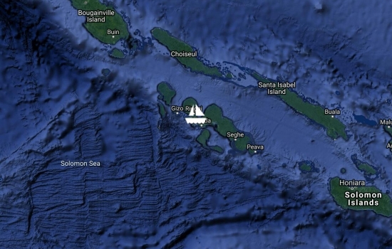
Left Gizo after period of rest and recovery. Now anchored at Lumo Nomana isl inside NW entrance of Vona Bona lagoon looking out to Kolombangara?s mountain top.
Left Gizo after period of rest and recovery. Now anchored at Lumo Nomana isl inside NW entrance of Vona Bona lagoon looking out to Kolombangara?s mountain top.
Anchored W of Gibson Isl in channel running N-S. Crocs cruising by! Shallow sand flats to west are all shades of blue. Peaceful
Sailed half way then motored the remaining 20nm to Ondolou Isl SW of Wagina, close to Choiseul main island. 20 nm from the Arvavons now. Perfect spot anchored fore & aft bum 20m from the beach.
Happy Birthday Gem. Looks a
Tactically sailed from Sanbis in Gizo to Poiete on Kolombangara with very fickle wind. We hope to make the Arnavons across the slot if a storm front comes through overnight.
Happy Birthday Gem! Happy
Arrived into Gizo?s lagoon & Anchored opposite the main town next to Logha island.
Anchored on the outer edge of Roviana Lagoon between Kundukundu and Hopei islands.
Arrived onto Vona Vona lagoon anchored opposite Zipola Habu Resort at Lolo island
What a gorgeous spot! Enjoy!
Anchored inside Lambete lagoon in the lee of Hombupeka island protected from the SW weather but close to town. Supplies stock up and await friend arrival
Spent 4 days in Bat Harbour on Kolombangara Island up a narrow creek to shelter from the passing of the low pressure system. Moving on today if weather allows
Great blog Gem! Glad you are

Anchored between Nusapate and Nununggara island to see out the bad weather and see in the New Year.
HAPPY NEW YEAR Capt'n Andi
Good to see you're tucked
Anchored inside the inner lagoon of Munda and Lambete on New Georgia island. Arrived yesterday as a ferocious storm hit and forced to make emergency anchoring while it passed. The westerly fetch across the water means we will gather supplies quickly and depart for a more secure haven tomorrow.
I see you. Where will you
After spending Xmas day at Tetepare We are now at Egholo harbour on N of Rendova island today. 3 villages with polite unimposing people eager to welcome us
Good news - about the less

Anchored opposite the rangers station inside NW lagoon, S of Nabo Point on Tetepare - the ?Last wild island?
Anchored at Ueipi island, the furthest point of Marovo Lagoon from the main islands. Protected marine area with lots of underwater life
Anchored at Lomalie Island in the southern bay close to Sambal island. Lomalie pass between the two is a good dive site
motor sailed 90nm to Noro on New Georgia overnight to get a new battery. Completed all chores & left into a heavy NE squall so took shelter in Ringgi Cove on Kolom Bangara Island.
steamed up to Sarumara anchorage today in the southern tip of Matiu island outer chain of Marovo. Greeted by friendly carvers from Telina village.
How did you get in? Seems to
anchored inside southern Marovo lagoon opposite Mbili pass at north Gatokae island. Sailed overnight from the Russell?s. No time for sleep as carvers keen to show us their work
reef reconnaissance today now anchored inside the lagoon of Hanasavi island nestled between two manta shaped reefs. Lots of fish life but poor coral cover. No inhabitants
Just a question How come
Arrived into Koemurin Island lagoon in the Russels over very shallow narrow entrance not charted.
Departed Honiara at 1100hrs now arrived at Roderick Bay, north Nggela Sule in Florida group. Welcomed by the family of the Yacht club. Anchoraged in 30m water!
Avg: 5.6knts
24hr: 133.4nm
arrived at Mbokona Bay, Honiara Solomons at 0800 hours. Anchorage very tight and rolly. Q flag raised. Distanced travelled 577 nm
Bloody marvellous. Look out
Congratulations! Good passage
period of no wind today in the shadow of S Cristobel then heavy sea state & 20 knots ne on other side. Dropping into the night. 63 nm to Honiara
Avg: 6.6knts
24hr: 159.6nm
sails gulled winged for downwind. We are now 16 nm south of San Cristobel Island, Solomons. 189 nm to our destination of Honiara on Guadalcanal.
Avg: 2.7knts
24hr: 65.6nm
on passage from Vanuatu to Honiara Solomons. 187 nm travelled 358 nm to go. Slow downwind progress
Sailed on a wsw storm from the Reef islands (Rowa) to Lorup bay, Ureparapara. We are anchored inside the (extinct) volcano crater
We are watching your
departed Sola Bay on Vanua Lava bound for the Reef islands for overnight. We have started our outbound journey from Vanuatu. A few days hopping north before the wind kicks in & away we will go.
Hope the weather plays the
motorsailed from Waterfall bay on W coast of Vanua Lava to Reef islands N of V Lava. Perfect reef weather
we have started our journey north. Currently sitting at Lonnoc bay on the north east coast of Santo
Hi Andrew and Gemma
gentle sail 10nm out of LV to Ratua Isl anchorage next to southern coast of Aore opp Malo in 2.5m sand
left Pentecost yesterday due to very heavy weather. Sailed back to Santo to move north of a depression forming near south Malekula. Since it has moved further south towards Efate so we are out of the dangerous quadrant.
> >
motor sailed to Loltong Bay N Pentecoste and anchored in 4m sand with reef surround opp the village to the beat of the drums
60 nm day sailing high to arrive at Marino on North Maewo Island. Huge wind shadow in the lee of Ambae due to the volcano suck. Crazy ash sunrise
60 nm day sailing high to arrive at Marino on North Maewo Island. Huge wind shadow in the lee of Ambae due to the volcano suck. Crazy ash sunrise
picked up Rob from the airport 2 days ago. Waiting in Palikulo Bay 10 nm from Luganville on Santo for the weather to stop squalling
passage from Uri island in port Stanley Malekula to Luganville today. Beautiful broad teCh rub with the head sail full winged. 45nm travelled. Anchored in Luganville Bay
Looks like a good passage.
anchored btween Awei & Malekula Islands in the Masquelynes. Deep Blue water mangroves reef and strong tidal currents
travelled from Emae Isl to Epi Isl today. Seastate smaller than yesterday. Covered 75 nm in 2 days to spend a few days in Lamen Bay. Black sand bottom clear water and many turtles
anchored in Matapu Bay Havannah Harbour on nw side of Efate Island. Spent 5 days in Port Villa. Travelled 30nm today
anchored in quarantine zone at Port Villa Efate Island Vanuatu. Overnight downwind headsail run from Erromango.
Island hopping I see, Trust
left Tanna early yesterday to arrived at Dillons Bay on Erromango in the daylight. 60 nm travelled
On the move again, hope the
Avg: 4.1knts
24hr: 99.5nm
arrived safely into Port Resolution, Tanna Island Vanuatu. Speedy sail bit of a dream run with Yasur volcano lighting the way glowing into the dawn
Avg: 8.3knts
24hr: 198.3nm
67 nm to go until Port Resolution, Tanna Vanuatu. Took down some sail area to slow down to arrive in daylight
Oh Wow , you have made good
departed New Caledonia via Havannah Passe at 1500. Passing Mare island of the Loyalties 14nm to the south. Next stop Vanuatu
You seem to be making good
checked out of Noumea on Friday now on a mooring at Ilot Casy in Baie de Prony waiting for the weather change to come through to to depart for Vanuatu. Best weather all month
We loved Ilot Casy, I’m sure
Looking good guys have fun
left Ile des Pins early on 15th July with overnight stop at Ilot Maito now at Ilot Kouare for some snorkelling 3 nm from the outer barrier reef
left Ile des Pins early on 15th July with overnight stop at Ilot Maito now at Ilot Kouare for some snorkelling 3 nm from the outer barrier reef
anchored in Baie de Kuto Ile des Pins.
Anchored in Baie de Kuto, Ile des Pins. Travelled 50nm today upwind slog. Hard going with some issues to sort but now safely anchored and both well. Plenty time now to recover dry out & do maintenance..
Anchored in Baie de la Tortue, Ile Ouen, S of Grande Terre heading for Ile des Pins. Red iron ore scarred mountains
anchored at Ilot Maître 3nm sw from Noumea. Kite surfers paradise in these winds
How idyllic that looks. I
Avg: 6.3knts
24hr: 151.5nm
Arrived safely into New Caledonia through Boulari Pass at 0500 EST 23.6.18. Currently on anchor near to Port Moselle, Noumea
bien joué. Profitez de votre
Absolutely bowled over. Hope
Avg: 5.6knts
24hr: 134.2nm
travelled over 600nm so just over 200nm to go to Noumea, New Caledonia
?????? 2 more sleeps before a
Oh Wow, you are doing well.
Over half way now and going
Avg: 6.7knts
24hr: 161.2nm
Nearly 200nm travelled so far on the passage from Gold Coast to Noumea. Steady downwind run awaiting wind shift to have a broad reach soon hopefully
Looking good - watching you
Updated nicely. Position now
Going well guys 200nm in the
Under headsail 60nm NE of Australia heading to New Caledonia Finally departed on our voyage. First ocean crossing together
Thinking of you at every wind
Enjoy the journey. xo
May this Adventure Fulfil
Stay safe guys. XXX
First post. Hi. All the prep and savings for the last 10 yrs is stowed and tight. Sitting at anchor waiting for next weather window and to sell our beloved Subaru. Still no bites.
New Caledonia is over the horizon
Bon Voyage - looking but not
No blogs available for this yacht.