Distracted
Back in our berth, Gulf Harbour Marina, stunning trip back.

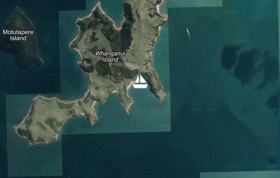
Deep Cove, Whanganui Island, Coromandel . A bit rolly
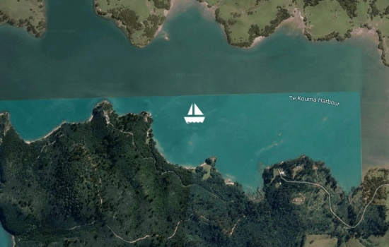
Name Bay, Te Kouma Harbour, Coromandel. Moved for SW approaching fast. Not too happy about cooler weather, rain welcome.
Squadron Bay, Te Kouma Harbour, Coromandel. Repositioned our lock down to await forecast weather at the weekend. Beautiful here.
Good morning buddies I

Awaawaroa Bay, Waiheke Island. Another stunning sunset, or be it an hour early. Locked down at our usual address.

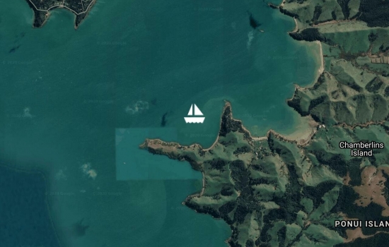
Apuapu Bay, Ponui Isalnd. Stunning sunset over Auckland and Skytower.
Clean bum, much faster in lockdown. No mountain biking, or van.
It was warm enough to venture

Awakiriapa Bay, Waiheke Island. the lock down continues.
very good fishing here, we've doubled our success's, two fish, both returned.
So pleased you have turned
Hi Faye & Albert (snoring),

Te Kawau Bay, Ponui Island.
Kauri Point, Ponui Island. Lockdown continues, still safe. Finding lots of chores.

Chamberlains Bay, Ponui Island, lockdown this afternoon.

Hooked in Hooks Bay, Waiheke Island. Isolated, safely.
Hi Gavin & Belinda , what a
Hi Doug & Sandra, what a

Port Fitzroy, Great Barrier. Very pleasant Easter weekend. Great company.
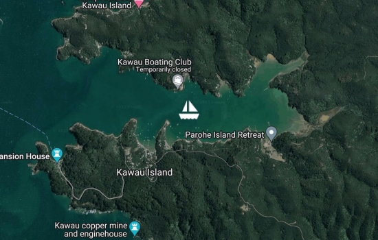
Bon Accord Harbour, Kawau Island, NZ. Calm before the rain and NW.
out for the night, very pleasant. Amazing how many other boats came in here last night. All happy on good ship Distracted with diesel heater cranked up.
Squadron Bay, Te Kouma Harbour, Coromandel. A dull wet morning, the strong NE has eased. The diesel heater is earning it's keep. A slow start this morning.
Wool Shed Bay, Coromandel. Diesel heater not working quite as hard this morning. Nice winter cruising but not the same as June last year (New Cal).
Deep Cove, Whanganui Island, Coromandel. Stunning morning. Diesel heater being thrashed, good work out.
Milford Island, Touwai Bay, Whangaroa Harbour. Sheltering from low pressure event, very comfortable here, decks are clean.
Whangaroa Harbour, Milford Island (Wairaupo). A stunning return, beautiful evening, still, warm and peaceful.
Merry Xmas from Sydney ,
Gulf Harbour Marina, safely back in our berth, trying to find reality.
Thanks to GHR for all their support.
Hi guys Welcome home look
Mansion House Bay, Kawau Island. Cold trip down from Tutakaka. A lovely sheltered anchorage and strangely empty.
Tutukaka Harbour, anchored for the night, very nice to be back here, although no flying fish, lots of penguins.
Avg: 14.9knts
24hr: 358nm
Tied up and cleared. opua.
Avg: 8.7knts
24hr: 209.7nm
Opua Marina, cleared, the first mate is happy and looking for a shower. Thanks to all.
Great to hear, welcome home!
Avg: 6.6knts
24hr: 158nm
Almost abeam Cape Karikari, no land in sight. Thought water temp would be too low for flying fish but no, one on deck this morning and numerous scid marks on the dodger. Heater going inside Distracted this morning. 40 NM from BOI. A good fast arrival.
A very fast journey
Avg: 6.7knts
24hr: 160.9nm
making good progress, 205nm from Opua, still at the rodeo. Sea & wind have eased overnight. Having to wear clothes, boots and socks not welcome.
Yay, nearly home! xxxx
Avg: 5.8knts
24hr: 138.7nm
Not quite laying up to waypoint in BOI, wind was NE for a while last night but shifted back to ENE early this morning.
The old bucking bronko is going for it.
still in holding pattern, very rolly & uncomfortable overnight. Great day catching up on chores yesterday.
Avg: 3.5knts
24hr: 83.3nm
Have decided to slow down and wait for squash zone to pass ahead of us, very easy conditions at present, A good night going nowhere. Wind has recently changed from S-SSW to ESE. All well on board (eating too much).
Eating to much isn't always
Avg: 6.3knts
24hr: 151.1nm
slow night motorsailing to windward and trying to get some money in the bank.
Avg: 7.5knts
24hr: 179.9nm
On passage from Isle des Pins to Opua. Pleasant conditions, a mix of motor sailing and the real thing. Beautiful sun rise this morning. All good. One flying fish on deck this morning.
Avg: 6.3knts
24hr: 151.7nm
all is well. A good start.
Baie de Kuto, Ile des Pins. Another cruise ship yesterday. A beautiful morning to be leaving.
Baie de Kuto, Ile des Pins. Another cruise ship yesterday. A beautiful morning. One more trip to the bakery and the final pack up for the sail home.
Baie de Kuto, Ile des Pins. Another cruise ship yesterday. A little rolly in here this morning.
Baie de Kuto, Ile des Pins. Stunning anchorage,alive with turtles, a dugong or two? ( a dugong flipped in front of me yesterday morning while paddleboarding) Lots of fish and remora. Cruise ship in yesterday, many Aussies, interesting. Looking at a Friday departure to NZ.
Baie de Kuto, Ile des Pins. Stunning anchorage, great to be back. Fast sail from Ile Casy yesterday morning. Dinner aboard Aradonna last night, very nice, fun.
Ile Casy, Baie de Prony. Isle des Pins tomorrow.
Port Moselle Marina, Noumea. A much quieter morning. Leaving for Prony this morning
Port Moselle Marina, Noumea. A much quieter morning.
Port Moselle Marina, Noumea. Still very breezy but hot by day. Very social.
Port Moselle Marina, Noumea.
Port Moselle Marina, Noumea. Rain here late yesterday and overnight, no rain since August 4th, the locals are very worried, bush fires at Komac.
Port Moselle Marina, Noumea. Preparations for our trip back to NZ are well underway. Has been very breezy here.
Port Moselle Marina, Noumea. Our visitors are off back to NZ this morning, a great time had by all.
Port Moselle Marina, Noumea. Parked with the locals, not the cruisers, for our sins. Off to do the tourist thing today, after a rig check. Visited the boatyard and Maritime Museum yesterday. The trip home is getting closer.
Ilot Amedee, still beautiful although a tad breezy and bumpy. Out unreliable Hidea outboard has failed us yet again, so not really possible to take our guest ashore. Onwards for the shelter and delights of Noumea today.
Pointe Mere, Bonne Anse. A quiet but pleasant motor sail up from Ilse Des Pins yesterday, the hoped for winds didn't come to much. No fish. Very nice anchorage here, great view of sunset.
Baie De Kuto, Ile Des Pins, still amazing, a visit around to Baie De Kanumera yesterday. Th Dugong has been making brief visits.
Hi there, we arrived in Kuto
Avg: 34.7knts
24hr: 833.9nm
Kuto, Iles Des Pins, New Caledonia. Nice moter sail down to Kuto from Ilse Casy yesterday, this place is still paradise, our guests don't want to leave.
Avg: 66.8knts
24hr: 1603.5nm
Ile Casy
Port Moselle, visitors arrived safely and now warm. Off to Prony this morning.
Port Moselle marina. Friends arriving from NZ today. Has been very breezy.
came back yesterday in 35kts to collect guests.
Port Moselle, marina
Ile Casy, Baie De Prony. Had a great sail from Ilot Ua. Witnessed a whale off Ilot Mato thrashing it's tale and blowing about every minute, this went on for about twenty minutes but got slower, not sure if whale was giving birth, bonking or what? never saw it's head (help please Dani). A fun evening with Masterplan and Jams, long overdue catchup. Breezy but hot.
What a show! Did you only see
Ilot Ua, beautiful Ilot, named after our first grandson. The birds on the Ilot, while beautiful are very protective. A bit bumpy here this morning.
Ilot Uatio. Another stunning Ilot and perfect for the weather conditions. Beautiful coral. After departing from Ilot Kouare we checked out the nearby barrier reef, Recif Neokouie, then out through Passe De Kouare and back, amazing colours and pipeline seas. Air temp. 26-27C during the day.
Avg: 69knts
24hr: 1654.8nm
Ilot Kouare, stunning anchorage, water colours are amazing. Green flash number two for the season last night. Another hot day yesterday. Paddle boarding shortly.
Avg: 70.4knts
24hr: 1688.6nm
Anse Majic, Bonne Anse. Quiet spot, on mooring. Very hot yesterday, chilly overnight. Off to Southern Lagoon this morning.
Baie Du Carenage, Prony, New Caledonia. Sheltered anchorage, good holding in red mud. Off to local warm pools this morning for weekly bath.
Ile Casy, Baie de Prony, in the company of Aradonna, a favorite spot.
Had to leave Ilse Ouen, Baie de la Tortue yesterday. A local boat with three kanaks in it, was harassing the other three boats in the anchorage, when they came to us one jumped on board Distracted and was very aggressive when asked to get off, after lots of yelling and verbal abuse he ordered us to leave his island and left with his mates. We were not going to hang around. All a bit of a worry.
Baie De La Tortue, Ile Quen. Very pretty bay, a few turtles with remora stuck to them. Good holding and sheltered. The resort appears to have closed and aerodrome nearby may be in operation although we only saw one small plane and it was going the wrong way for a take off or landing. Warm by day, chilly nights.
Ilot Mato, stunning lagoon, beautiful blue green water, sheltered from sea, excellent holding.A bit breezy this morning. No paddle boarding this morning.Great result last night.
Ilot Mato, stunning lagoon, beautiful blue green water, sheltered from sea, excellent holding. Not as much sea life as Amedee, or people and boats. More paddle boarding this morning.
Ilot Amedee, on a mooring, sheltered, great snorkling and paddle boarding. Amazing sea life, lots of turtles unfortunatly for them many have remora attched to them. Seagulls protected here and very nasty. Very warm by day.
Ilot Maitre, on a mooring, sheltered, great views and paddle boarding. The hotel rooms above the water are not very attractive, the coral is good and lots of turtles. A blanket and sheet last night.
Baie Maa, New Caledonia. Spent yesterday at Ilot Signal, came back when seas got up late in the afternoon.Saw our first "Green Flash" for the season last evening. Off for a paddle.
Baie Maa, New Caledonia. Lovely sheltered anchorage.Very breezy yesterday, nice long walk. Off for a paddle.
Baie Maa, New Caledonia. Lovely sheltered anchorage.Went to Aradonna for drinks and dinner, fun had by all. Off for a paddle.
Baie Maa, New Caledonia. Lovely sheltered anchorage, a bit breezy yesterday but died out overnight. Aradonna came for drinks and dinner, fun had by all. Off for a paddle.
Port Moselle, Port De Noumea, New Caledonia. Out to cruise Southern Lagoon this morning after a visit to the market. Saturday is a special morning at the Noumea market.
Port Moselle, Port de Noumea, New Caledonia. In a berth, cleared Customs, off to town to clear immagration this morning.And market delights.
Anse Majic, Bonne Anse, New Caledonia. A trip to Lle Casy for the afternoon to feed the dog and back to Bonne Anse for the night and dinner with Per de Lune, onwards today.
Baie Du Cap, Bonne Anse, New Caledonia. Time to catch up with old friends. A new anchorage for us, difficult to get a good hold but beautiful. A tad colder than we've been used to.
Avg: 18.8knts
24hr: 451.3nm
Port Boise, New Caledonia. Very pleasant motor sail down from Lifou. Cleared biosecurity on beach at Baie de Gaactha, communicated via loud voices, novel.
Stopped outside Canal de la Havannah to let tsunami pass, non event but prudent. Looking for the elusive "Curried Prawns".
Avg: 6.5knts
24hr: 155.2nm
waiting outside Havannah pass GrandeTerre.
Avg: 3.6knts
24hr: 86.8nm
Baie de Gaatcha, Lifou, Iles Loyaute, New Caledonia. A good fast sail, arrived here about 1630 yesterday, stunning clear blue / green water. Good anchorage. Huge sleep.
Avg: 6.1knts
24hr: 146.7nm
On passage from Port Vila to Lifou. Very pleasant sail, departed Vila 1100 yesterday morning, full moon, boobie hitch hiker on mast top from 0000 - 0400.
Port Vila. Off to vote this morning, then depart for The Loyalties. Laundry returned to Yachting World.
Port Vila, Efate. Preparing to depart tomorrow morning after voting at NZHC. All going well apart from laundry going missing last night.
Port Vila, Efate. Amazing day here yesterday, new waterfront park opened by NZHC on Friday, kids of Vila really enjoying it, great effort by NZ.
Port Vila, Efate. Back to prepare for departure to New Caledonia, possibly Wednesday after voting at NZHC. Spent yesterday afternoon at Mele Bay, a bit rolly.
Esema Bay, Port Havannah, Efate. Great watching turtles all around us yesterday, the odd small sea snake. To the north of our position are four large steel mooring bouys, unlit. Apparently hurricane moorings. Care should be taken if coming here at night.
Esema Bay, Port Havannah, Efate. Back to an old favourite anchorage.
Port Charles, Undine Bay, Efate. We went around to Undine Bay today to check out the residential development, greeted by two sharks on the way into the small marina, but chose not to stay. Now back in Esma Bay. This morning after praising our anchorage it took us an hour to retrieve our anchor, caught on demolition dumpings, we don't recommend the anchorage we stayed in last night.
Port Havannah, Efate. A construction site at this end of the bay, sheltered and good holding in sand.
Richards Reef, Port Havannah, Efate. This spot is very special.
Richards Reef, Port Havannah, Efate. Saw a big fat dugong outside The Havannah while paddle boarding this morning, also numerous sea snakes resting on the reef.
Nice! Vanuatu really is
Esema Bay, Port Havannah, Efate. Great weather here, back to an old favorite anchorage.
Richards Reef, Port Havannah, Efate. Fantastic anchorage in easterly conditions, frinedly locals.
Port Vila, off to Port Havannah this morning
Port Vila, still stocking up, visited NZHC, will vote there on 6th Sept.
Moorings now almost full in here (ICA)
Port Vila, restocking, more boats arriving constantly.
Port Vila, Efate. Restocking and catching up with old friends
Port Havannah, Efate. Off to Port Vila this morning.
Lalepa Island, Port Havannah, Efate, Vanuatu. Amazing morning, warm, still and sunny. Great safe anchorage in westerly conditions. Good trip down from Epi yesterday, light easterlies went light westerlies, flat seas.
on passage Epi to Havannah harbour
Revolieu Bay, Epi. Sheltered from swell behind reef. Off to Havannah Harbour soon.
Avg: 4.3knts
24hr: 102.9nm
Lameh Bay, Epi. Great sail across for Malakula, spotted five whales breaching. Whistle stop for horse trading. Will move down to Revolieu Bay for early departure to Havannah in morning.
Love it, well I'm going home
Port Sandwich, Malakula. Moved slightly could not see Ambryn volcanoe last night. Stunning safe anchorage.YITsters gone. Amazing how French stripped Lamap on departure.
Port Sandwich, Malakula. Great view of one of Ambrin's volcanoes last night. Nice anchorage.
Gaspard Bay, Maskelyne Islands, Malakula.
Awei Island, Maskelyne Isalands, Malakula. Happy Birthday to YITster Mike.
Happy birthday Gavin,
Happy Birthday Michael.
Caroline Bay, Malakula
Lorlow, Metenovor Bay (SW Bay), Malakula.
Lorlow, Metenovor Bay, Malakula. Anchored at Munvet Point yesterday, very sheltered but mozzies became issue late in day, YITsters became unsettled.
My heart bleeds for you will
Tisvel Bay, Malakula
Malua Bay, Malakula, Vanauatu
Aore, Luganville, Santo.
Aore, Luganville, Santo.
Aore, Luganville, Santo.
On our way! What are you most
Aore, Luganville, Santo. Town will be much safer today, cruise ship gone. Shopping can continue.
How many coconuts do you need
Aore, Luganville, Espiritu Santo
Andrews Point, Baldwin Cove, Espiritu Santo. Lovely anchorage, Tx GHR. The resort appears to be being rebuilt. A frenchman advised us this is a private bay, we could not go ashore but could stay the night. Onto Luganville this morning.
Andrews Point, Baldwin Cove, Espiritu Santo. Lovely anchorage, Tx GHR. The resort appears to be being rebuilt. A frenchman advised us this is a private bay, we could not go ashore but could stay the night. Onto Luganville this morning.
Lisburn, Cape Mataavea, Espiritu Santo
Lisburn, Cape Mataavea, Espiritu Santo
Hi Guys -3 frost this morning
Lisburn Anchorage, Cape Mataavea, Espiritu Santo. A spirited sail today 10 - 35kt S, 2.5 - 3.5m S sea, well worth the effort, first anchorage in a month with no roll and very sheltered. A lot to explore here. Could be here for a while.
Avg: 3.6knts
24hr: 85.2nm
Wusi Bay, Espiritu Santo. Another with two islands in it according to Navionics, not a one to be seen. A lovely sail down the coast.
Wunpuko, Espiritu Santo
Avg: 7knts
24hr: 167.6nm
Wunpuko, Espiritu Santo
on passage to the NW anchorage on Espiritu Santo
Veutumboso, Vanua Lava
Sasar Waterfalls, Vanua Lava, Banks Islands. Paradise.
Sasar Waterfalls, Vanua Lava, Banks Islands. Paradise.
Nice anchorage especially
Sasar Waterfalls, Vanua Lava, Banks Islands. Paradise.
Sasar waterfalls, Vanua Lava, beautiful, isolated and shared with two generous, small villages.
Sola Bay, Port Patteson, Vanua Lava.
Veutumboso Bay, Vanua Lava.
Kwetevut Bay, Santa Maria, moving on to Sola this morning
Kwetevut Bay, Santa Maria Island. Great sail yesterday, 30kt as we approached Is. Nice anchorage, Tx GHR. Olivia with us
Port Olry, Santo. Deparing for Santa Maria this morning, with Olivia
Malvoror Island, Thion, Port Olry, Santo
Thion Island, Port Olry, Santo
Lonock Bay, Hog Harbour, Santo. Olivia One in company.
Lonock Bay, Hog Harbour, Espiritu Santo. Australian yacht Olivio nearby, too shy to talk to GHR.
Champaigne Beach, Hog Harbour, Espiritu Santo. Stunning anchorage
Yes very nice part of the
Palikulo Bay, 9 yachts here.
Palikulo Bay
Palikula Bay, Espiritu Santo
Aore, Lugnaville, Espiritu Santo
Aore (on a mooring along from resort), Luganville, Espiritu Santo
Aore, Luganville, Espirito Santo.
Calm, CC 100% recent rain, Bar. 1011
Palikulo Bay.
calm, CC 50%, recent rain. Bar. 1011
Palkulo Bay, Espiritu Santo
Palikulo Bay, Espiritu Santo
Vanihe Bay, Aoba
Asanvari
Asanvari
Asanvari, Maewo. A beautiful bay, sheltered from sea & wind anchorage. Unfortunately they lost their yacht club during the cyclone, reopen new club in July/August.
Bwatnapne Bay, Ile Pentecote, Vanuatu.
Ranmawat (Waterfall Bay), Ile Pentecote. Well done ETNZ
Homo Bay, Ile Pentecote, water & laundry day yesterday. Go ETNZ
Homo Bay, Ile Pentecote, Vanuatu. Nice fast sail away from volcanic cloud of Ambryn yesterday afternoon.
Hi Gordon and Bindy
Ambryn, off village Ranon, very hot and humid still conditions, be very pleased when trades reappear.
Epi, Morevi Point, Olivia anchored next to us, a bit rolly.
Laman Bay, Epi. Olivia One is anchored next to us. Great spot, visit from dugong and dolphins
Avg: 2.8knts
24hr: 68.4nm
Lameh Bay, Epi. Olivia One is anchored next to us
Vanuatu, Port Havannah, Samoa Point.
calm, 100% CC, Bar. 1011
Go ETNZ
In London watching team NZ
Port Havannah
Calm, 75% CC (high), Bar. 1013
Port Havannah, Richards Reefs.
Calm, CC 80% (high), Bar. 1012
Good to back here after four years, new resort at Moso Village and super yacht onshore next to resort, had been anchored here 4 years ago.
Port Havannah, Esema Bay
Calm, CC 40%, Bar. 1013
Port Vila
Calm, 95% CC, Bar. 1014
Port Vila
Calm, CC 50%? recent rain, Bar. 1014
Calm, CC 60%, Bar. 1013.
Port Vila, stunning weather over the weekend
Avg: 4.4knts
24hr: 105.3nm
Port Vila.
S 5kts, 40% CC, Bar. 1010
Port Vila, Vanuatu. On mooring outside Yachting World. All cleared and under internet tree. Thanks to David and Patricia for all their help & humour.
Avg: 4.5knts
24hr: 107.6nm
in P Vila
Avg: 6.8knts
24hr: 163.7nm
Will keep the pedal down so 11.5 hours to Port Vila. gave us the news of the Americas cup crash and mast loss for NZ against UK in Bermuda. Poo
Baie de Tadine, Mare, Iles Loyaute
Avg: 6.6knts
24hr: 157.9nm
Baie de Tadine, Mare, Iles Loyaute
Port Boise, about to sail for Mare
Baie de Prony
Anse Du Pilote, Canal Woodin.
Baie de L'Orphelinat, Noumea, now cleared out
Baie De L'Orphelinat, Noumea. The Australian invasion has arrived in town.
Baie Maa, about to move to Noumea to clear out for Anatom
Baie Maa
Uitoe, Pointe Caouritta
Ile Ndukue
You guys are missing all the
Avg: 7.7knts
24hr: 185.1nm
Ile Ronde, a little piece of paradise (yesterday)
Ile Abu, Baie De Uitoe
Ile T'Ndu
Ilot Mbe Kouen
Hi guys we have been
Ilot Mbe Kouen, stunning anchorage.
Baie Maa, anchored here last night after a lovely afternoon at Ilot Te Ndu, got a bit rolly as the tide came up.
Port Moselle, Noumea. Calm, 0% cc, bar. 1011
Avg: 3.5knts
24hr: 83.7nm
Reef entry at Amedee @ 0745. Port Moselle Marina @ 1030.
Great trip.
Avg: 7.3knts
24hr: 174.1nm
16nm from Amedee entrance, should be in just after daylight
Well done the admiral.
Hope you have the champagne
Avg: 7.1knts
24hr: 171.4nm
sailing downwind trying to encourage more east from wind.
Great to see you making such
Avg: 6.1knts
24hr: 147.6nm
motorsailed all night to windward in light NW. Now reaching in 10-12kt SW. seas have calmed right down. Life is fantastic.
You will be there before you
Avg: 7.6knts
24hr: 182.8nm
bumpy night trying to get over top of Norfolk Is before NW arrives.
Avg: 7knts
24hr: 168.2nm
Pleasant motor sailing, sea has settled. Adverse current annoying. Beautiful moon lit night.
Avg: 7.7knts
24hr: 184.1nm
unsettled sea, great to be back out here. good progress
Hi Guys have been following
Safe travels guys
Bon voyage. Have a safe trip
10kt SW, 5% cc, 1014
Cleared customs 0800, exiting BOI.
Stunning day to depart NZ
Hope you have a great passage
Matauwhi Bay, Russell. Bay of Islands. Waiting patiently.
Hi guys
Hi guys
don't be a sook thort you
Safe travels when you get to
Safe travels when you get to
Deep Water Cove, Bay of Islands
E 5kts, 5%cc, 1024. stunning evening.
Teparapara Bay, Whangaruru Harbour
15kt SW, 95% cc.
Urquharts Bay. Quick trip from Kawau
Out of Gulf Harbour, anchored in School House Bay, Kawau Island. Waiting for TC 99P to decide where it's going.
Bryants Bay, Ponui Island. Not nearly as exciting as Chameleon at sea. :position 36 51.305s 175 11.886e
Otarawao Bay, Mahurangi Heads :position 36 30.705s 174 43.604e
Urquharts Bay, Whangarei Heads :position 35 50.868s 174 31.791e
Oakura Bay, Whangaruru Harbour :position 35 22.635s 174 20.690e
Patunga Point, Whangaruru Harbour :position 35 21.522s 174 20.069s
Whangamumu Harbour 35 15.035s 174 17.785e
Avg: 6.3knts
24hr: 151.2nm
Pacific Bay, Tutukaka Harbour :position 35 36.000s 174 32.189e
Hi , will you still be around
Omahungaiti Bay, Great Barrier Island :position 36 08.808s 175 26.578e
Stony Bay, Port Fitzroy, Great Barrier Island.
:position 36 10.896s 175 20.199e
Raktu Island (Arid Island), The Cove :position 36 07.239s 175 29.596e
Harotaonga Bay, Great Barrier Island (08 01 2017) :position 36 09.869s 175 29.012e
Little Bay, Waikawau, Coromandel Peninsula.
Greeted by a smiley seal as we entered Little Bay, soon after anchoring we spotted a pod of Orca working the bay, guess the seal became lunch.
We made the local swimmers aware of the pod, most were in black wet suits.
No casualties, as of yet.
Hehe, hopefully the seal
Kennedy Bay, Coromandel Peninsula :position 36 40.218s 175 34.049e
Whitianga Marina, Whitianga Harbour :position 36 50.157s 175 42.449e
Matapaua Bay, Mercury Bay sition 36 44.423s 175 48.572e
Humbug Bay, Mercury Bay tion 36 44.523s 175 49.487e
Avg: 394knts
24hr: 9456nm
Momona Bay, Great Mercury Island (31 12 2016)
Avg: 394knts
24hr: 9456nm
Port Charles, Coromandel (30 12 2016) After almost two weeks at Barrier catching up with cruising, racing and Wellington friends, time to purge the bodies.
Avg: 4.8knts
24hr: 115.3nm
Momona Bay, Great Mercury Island.
:position 36 38.328s 175 47.510e
Port Charles, Coromandel Peninsula After almost two weeks at Barrier catching up with cruising, racing and Wellington friends, time to purge the bodies.
Whangaparapara Harbour, Great Barrier Island :position 36 14.970s 175 23.893e
Smokehouse Bay, Great Barrier Island :position 36 11.779s 175 19.893e
Hi Gavin & Belinda , we also
Big Bay, outside Mahurangi Harbour
Chamberlains Bay, Waiheke Island
Man O' War Bay, Waiheke Island.
Enjoy your weekend B&S , talk
Oneroa Bay, Waiheke Island, anchored Fast sail to Oneroa Bay, Waiheke Island, 20 - 30kt westerly, sheltered, occasional showers.
Kawau Island, Bon Accord Harbour. On mooring at Kawau Yacht Club, very nice evening, rain has stopped.
Moturekareka Island.
Stunning winter afternoon. Good to be back out, water temp only 13degrees.
Motuwi Island, Coromandel. Calm and cold, diesel heater working overtime. Stunning QB weekend weather.
:position 36 40.536s 175 24.003e
Whanganui Island, Coromandel Nice winter cruising, cold but refreshing.
Motuketekete Island 36 28.153s 174 48.376e
Kawau Island, Bon Accord Harbour, KBC.
Not far enough north, missed "Fusio" :position 36 25.306s 174 50.260e
Pakatoa Island 7.574s 175 11.595e
Oneroa Bay, Waiheke Island.
position 36 46.734s 175 00.780e
Anchored in Woody Bay, Rakino Island :position 36 42.878s 174 56.545e
Maori Garden Bay, Rakino Island Fifteen boats here, peaceful night, recent shower, calm.
Bryants Bay, Poniu Island Another beautiful anchorage, only about 30 other boats to share with.
Chamberlains Bay, Ponui Island Lovely anchorage, over one hundred boats agree, have caught up with some old friends.
HI Gavin & Belinda, it is
anchored in West Bay, Rakino Island light SE, clear sky, sun up. stunning morning.
Moturekareka Island Lovely evening, one other yacht has just arrived to share this perfect anchorage. Now four others, beautiful morning.
Lovely evening, one other yacht has just arrived to share this perfect anchorage.
West Bay, Rakino Island. Beautiful morning. Bay chocker.
Administration Bay, Motutapu Island. All to ourselves.
Prospect Bay, Kawau Bay. rain stopped for now.
Bon Accord Harbour, Kawau Island.
Great trip down from Bay of Islands
Pomare Bay, BOI. Pleasant sail down from Whangaroa.
Touwai Bay, Whangaroa Harbour, great trip up.
Teparapara Bay, Whangaruru Harbour
Tutukaka Marine, brief stop over.
anchored in Kiwiriki Bay, Great Barrier. Great sail, 20-25kt SW. Nice to be back.
Gulf Harbour Marina. The planning starts for the next adventure.
since when have you been an
Kawau Island Yacht Club, one last night out
anchored in Smugglers Bay, Bream Head.
Avg: 7knts
24hr: 167nm
Opua, Q dock. Many thanks to David, Patricia and MetBob & of course YIT for a safe, slow uneventful trip.
Welcome home! Enjoy a Bloody
Avg: 6.5knts
24hr: 155.3nm
motor / sailing, approaching NZ, 60nm from North Cape. buzzed by RNZAF Orion yesterday afternoon.
Avg: 7.4knts
24hr: 177.9nm
approaching NZ, getting colder. nice sailing conditions this morning
Avg: 5.9knts
24hr: 140.7nm
motor! sailing, yesterday was a long day looking at Norfolk Is.
You will get there in the end
Avg: 6knts
24hr: 144.7nm
motorsailing, more motor than sail. approaching Norfolk Island
Avg: 6.5knts
24hr: 155.8nm
motorsailing, 160nm from Norfolk Is., stunning morning
Avg: 7.7knts
24hr: 184.1nm
Avg: 6.3knts
24hr: 151.2nm
very pleasant trip so far, lots of stars, bit chilly now. sea a little confused, SE 0.5
a lovely day to leave Kuto for Marsden Cove
Have a good trip guys, we are
were thinking about Th departure - before they heard the wx!
Avg: 4.7knts
24hr: 112.3nm
Baie de Kuto, Ile des Pins. Nice trip down, 10-12 S, overcast sky cleared.
leaving Baie de Prony for Ilse de Pins
anchored outside Port Mossell Marina, Noumea
Avg: 87knts
24hr: 2088nm
Baie Maa, an old favourite, great afternoon out at Ilot Mbe Kouen.
Ilot Mbe Kouen, beautiful day anchorage.
:position 22 15.577s 166 13.272e
Ile Ndukue, light SW blowing in, may not stay.(1100hrs local)
Isle Puen, Point Moziman.
SSE 10-15, cc 15%, bar. 1018 :position 21 57 787s 165 56.810e
Hey guys, don't forget to add
Ile Lebris, back in the south lagoon (1400hrs local), stunning sunset. great trip down the west coast.
SE 10kts, cc 75% very high, bar. 1018 (1830hrs local) :position 21 48.905s 165 45.169e
Ile Grimault, another early start, good trip. Currently SE 12, cc 30%, bar. 1019 :position 21 21.049s 164 59.362e
Avg: 3knts
24hr: 73.1nm
Baie Chasseloup, nice trip from Koumac, left 0545 arrived 1200.
Had a fantastic time in Koumac, Nathalie & Sylvain took us to the open day at the Tiebaghi mine on Sunday and caving on Monday, very exciting. Many thanks.
current (1700) SSE 20kts, cc 90% , bar. 1018
left Koumac for Chasseloup
Koumac, waiting. weather; calm, 100% cc, fine, bar. 1020
Port Ouenghi is situated in
Koumac Marina.
Pointe Pandop, Anse de Koumac. early start to beat the trades, nice to return. Back in company of our new German friends on Ui.
Ile Tanle, Baie de Tanle, bit breezy, makes Poum look very good
Poum, NW New Cal.
SE10kts, cc 20%, bar. 1018 @ 0730 local, temp 23c.
We are enjoying being back at Poum, apart from being very sheltered it is also very beautiful. And listening to GH Radio, I think we're very sheltered. Last year we visited and decided the local attitude was very bad, as was the state of the town, tagging, all street lights broken, trash everywhere and the PO had been set alight. This year there is a new supermache / hardware / petrol / diesel station which has been completed and close to the wharf,is staffed by very helpful, friendly locals. There appears to be pride in the town now which is tidy and free of rubbish. We plan to stay here for a few days.
Enjoy the far north, you are
Poum, very nice to be back in the pretty town, Good trip from Baie de Pam (50nm) ESE 15-20kt, turned S 10kt as we approached Poum.
Baie de Pam
Avg: 6.3knts
24hr: 152.2nm
Baie de Pam (Phwa Jiahot Paam) Good fast sail, 20-25kt ESE, maybe around to Poume tomorrow.
Hienghene ESE 5kts, cc 90%, bar. 1019
Hiengene, a breezy trip.
Touho, Baie de Touho, very pretty town, sheltered anchorage.
You keep teasing us with talk
Baie Laugier, a very nice anchorage, visited Aoumou yesterday.
Baie Laugier, half along the east coast of Nouvelle Caledonie
Baie de Canala, Anse Fanny, Port Mackau
Anse Toupeti, Ile Toupeti, another beautiful, safe bay.
Baie De Kouakoue, picture perfect anchorage, very sheltered.
anchored in Anse Du Pilote, Canal Woodin.
Left Noumea at midday, on our way to east coast of New Cal.
Great stop over in Noumea, caught up with many friends
Port Moselle, Noumea. cleared in. nice to be back
Hi Gavin and Bindy
Ile Uere. Great catch up with Aradonna last night and tonight.
Noumea to clear in the morning.
Avg: 5.3knts
24hr: 128.1nm
Arrived at Ile Casy, Bae deProny 1115 NZST, great trip, tx to Gulf Harbour Radio and MetBob. Nice to be back.
Avg: 8knts
24hr: 192.1nm
16nm from Havannah Pass, lovely morning, motorsailing.
Avg: 7.7knts
24hr: 184.7nm
passing Anatom, motorsailing.
Avg: 8.3knts
24hr: 199.2nm
another good night, one tuck & stays'l. a bright planet? in the sky behind us this morning, not very high.
good nights sail on the way to Noumea, two tucks, stays'l
Looking like a good start.
Avg: 7.3knts
24hr: 175.8nm
good nights sail on the way to Noumea, two tucks, stays'l
cleared from Lautoka, on our way to New Caledonia
Saweni Bay, beautiful afternoon.
Denerau, preparing to depart for New Caledonia on Monday
Hope you have a great passage
anchored off Likuliku Resort, Malolo Island, Fiji.
Monuriki Island, Mamanuca Islands, stunning beach, snorkling and scenery.
Monu Island, Mamanuca Islands, stunning day anchorage
Liku Liku Resort, Malolo Island
Malolo Island, near the village Yaro, sheltered from brisk southerly.
Tropocana, Malolo Island.
Denerau, Fiji. Mike and Dani on their way back to NZ. Distracted moving on for more adventures.
Avg: 3.7knts
24hr: 87.9nm
Saweni Bay after a nice sail from Navandra bay. Gorgeous day for the move. Just about to have a nice pizza for lunch and jump in for a swim!
Navandra, very pleasant night, not the usual roll, a little breezy from the SW for a while last night.
Nanuya-Sewa, Blue Lagoon, a lot of neighbours.
Moved from Vunayawa Bay to near vomo reef to get out of the roll. Went for a walk to east side of the island and saw a lovely old couple and gave them a gift of chocolate (whittaker's of course!) and tinned corned beef.
Vunayawa Bay, Naviti.
Sevusevu complete at Somosomo Village
Snorkelling with these guys (see photos) this morning in Manta Pass, now at Somosomo Bay, Naviti. time for Sevusevu.


Cuvu Bay, Naviti, Yasawas.
NW Kuata, Waya, nice trip up from Mana.
Mana Island, Fiji
Wonderful to follow your
Likiliki
Musket Cove for AB game and two birthdays
back in Paradise
Denerau Marina, picking up VIPs'
long day from Nana I Ra to Saweni Bay, mix of conditions from 20kt S to nil to 25kt S. Saweni flat water but breezy. Plenty of sun all day, no rain.
Nana I Ra, wet trip with very little visability at times, spotted two whales, nice calm reef entry with good sun
Nadi Bay,Nasavu, Fiji. Pleasant but wet run from Savusavu.
Savusavu, Fiji. Copra Shed Marina. No (good) HF service.
Have a great holiday David & Patrica, hope the flight doesn't last too long.
Avg: 4.5knts
24hr: 108.7nm
Arrived in Savusavu this morning, great trip
Avg: 6.9knts
24hr: 165.1nm
approaching Eastern Explorer Group, Fiji. Nice sailing conditions.
Avg: 6knts
24hr: 144.8nm
on passage from Nuiatoputapu to Savusavu ETA Monday AM.
Niuatoputapu, departing 1200 for Savusavu
Niuatoputapu, Tonga.
Niuatoputapu, Tonga. Beautiful Island, recovered well from 2009 Tsunami.
leaving Friday from Nuituputapu to Savusavu, eta Monday
Niuatoputapu Harbour, Niuatoputapu, Tonga. Flat water, good holding. Wind generator working well.
Avg: 7.2knts
24hr: 173.7nm
approaching Niuatoputapu,6nm out, Tonga.
Port Maurelle, Vavau
Nieafu, Vavau
Malafakalave, Vavau. great weather yesterday but NE prevented stopping at southern islands.
Kenutu Isalnd, Vavau. absolutely beautiful. the Pacific breaks against the island in an amazing display. Great to watch from top of island, someone has built a platform up there.
Mafana Island, Vavau
If you get a chance, make
Neiafu, Vava'u. GO THE HURRICAINES. watching TV at Mangos tonight.
Port Maurelle, Vavau. Stunning weather yesterday. Full moon and Venus & Jupiter made for a spectacular night.
Avaldu Island, Vavau, beautiful anchorage, amazing colours, white beach.
Malafakalava, Vavau. Very sheltered, stunning anchorage, lots of bird life & batts (no bugs)
Malafakalava, Vavau, stunning anchorage, very sheltered
Looks great where you,are,
Great spot you are in. Been
Afo, Vavau
Afo (11), Vavau
Greetings from GH. Looks like
Neiafu, Vavau. on a mooring for a few days
Vakaeitu Island (16) Vavau, no whales in here yet, saw one whale on arrival Tuesday.
Vakaeitu Island, no.16, Vavaua, breezy night
Avg: 2.6knts
24hr: 61.7nm
Vakaeitu Islaand, Vavau. Good trip up yesterday
sailing to Vavau, nice night at Haano Is.
Haano Island, Setila. more Ha'apai beauty.
Uoleva Island, Ha'apais'. Rolly night, rain yesterday afternoon and early evening
Uoleva Island, now five yachts here.
Uoleva Island, interesting Whale Watch / Eco tourism locla buisness's, including Yacht Club bar.
Uoleva Island, now four yachts here, small community growing
Uoleva Island, Ha'apai Group, beautiful sandy beach.
Nomuka Ika, squall last night, filled forward tank. Congrats to Carl & Heather
anchored at Haafeva Is, a bit bouncy this morning.
Haafeva Is., Ha'apai's. Another stunning Tonga anchorage, we love this place.
O'ua Is., Ha'apais'.
Beabea Is, stunning anchorage. no internet tree.Paradise. Bindy and I have now both read Anna Kirtlan's book "Which Way Is Starboard Again" a fantastic read. Well done Anna.
Nomuka Ika, another magic day and night
Nomuka Ika,stunning sunrise, amazing moon last night
Nomuka Ika, beautiful anchorage, peaceful night.
Kelefesia Is. fast rip from Nuku'alofa yesterday, very small anchorage here, very rolly night.
Pangaimotu, Nuku'alofa. torrential rain during the night, lightening and wind from all directions about 15-20kts.
Hopefully off tomorrow if visability is ok.
Pangaimotu, Nuku'alofa. rain most yesterday and last night.
seven other yachts anchored here. cruise ship in yesterday
visa extension granted
still anchored at Pangaimoto, Nuku'alofa. Visa extension today maybe.
could be worse, you're blog
The islands of the Ha'apai
still anchored at Big Mommas' Yacht Club
waiting for visa extensions, could be worse places to wait.
Anchored in Nuku'alofa harbour, diesel fill up day, today
prompted a talk on mare's tails in the sub tropics
well done....enjoy the warmth
Avg: 4.6knts
24hr: 111nm
anchored in Nuku'alofa Harbour, quiet and still, arrived about 1500, hopefully clear in Monday.
Well done Sniffy and Bindy.
Sounds like a great trip.
Well done, enjoy the warmth.
Avg: 7.4knts
24hr: 177.2nm
motorsailing on & off, intermittent rain. Tongatapu this afternoon, maybe.
Avg: 7knts
24hr: 167.8nm
motorsailing on & off, warm. water temp 25.7c
Looks like you are too far
Avg: 19.5knts
24hr: 467.8nm
oops fat finger syndrome, or ready for bed. Stunning morning.
Avg: 8.1knts
24hr: 194.7nm
another stunning night, motor sailing, clear skies, lots of stars and much warmer (less gear), water temp 23.2c
Really? 21 degrees S and 175
Clearly one too many hell
Avg: 8.3knts
24hr: 198.5nm
fast sailing all night,good progress.
You are going well. Plenty
Wow, great run. Nearly broke
Avg: 6.6knts
24hr: 158.5nm
another lovely night, getting warmer, stopped engine for 2hrs during night but wind faded, had to restart. Life is great.
Southerly gales forecast for
Good work Sniffy. Pretty much
Sail safe, enjoy the
Avg: 6.7knts
24hr: 160.3nm
motor sailing, very pleasant conditions, water getting warmer,21 degrees.
Good progress Sniffy, and
Avg: 3.9knts
24hr: 92.6nm
motor sailing,light SW going the same way as us.
Hi guys noticed the empty
in Urquharts Bay for the night. will clear from Marsden Cove in the morning, Tonga bound.
Enjoy your time away Very
Bryants Bay, Ponui Island
Hooks Bay, Waiheke Island.
Ponui Island, between Green Bay & Apuapu Bay
Little Bay, Waiheke. Very pleasant, great sun and view of Skytower.
Avg: 3.3knts
24hr: 79.3nm
Ngaio Bay, Mahurangi. Dinghy trip to Warkworth, fun, nice beer.
Goldsworthy Bay, happy new year to all
Urquharts Bay, nice trip down from Whangaruru via Tutukaka, farewell to Dani & Mike.
Stopped for the night in Whangaruru harbour. Glorious day, flat anchorage with lots of launches rafted up next to us.


Mimiwhangata, Whangaruru Bay. Full onboard YIT testing team.


Pacific Bay, Tutukaka Harbour
Urquharts Bay
Dispute Cove, Kawau Island
moored in Gulf Harbour Marina, planing our next adventure, many thanks to Gulf Harbour Radio, Metbob and Mike and Dani (YIT) for a safe, fun trip Blue sunny skies and light winds
Avg: 3.6knts
24hr: 86.4nm
anchored at Kawau Island, Mansion House Bay, cleared in Marsden Cove this morning, great experience, nice people. About to be joined by family from Snells Berach.
Great trip home. YIT gets better & better for all, thanks Mike.
Avg: 7.7knts
24hr: 185nm
approaching Bream Head. Clearing at Marsden Cove. Did I mention the cold
Avg: 8.1knts
24hr: 195nm
bumpy night, cold, boots, socks & beanie. Good sailing last 24hrs.
Avg: 6.6knts
24hr: 157.3nm
motorsailing to windward, able to lay up to Cape Brett, wind coming around to SW for now. Bloody cold.
Avg: 5.3knts
24hr: 126.3nm
eta AKL friday pm
Avg: 7.6knts
24hr: 181.2nm
motor sailing, rain (not happy putting on wet weather gear)
Avg: 7.6knts
24hr: 183.3nm
motor sailing since 1600 Saturday, motor off @ 0300, up on coarse a little.
Departed Isle des Pins 0630 local yesterday. Very pleasant night, no wind, burning diesel. Trip started quickly, SE-ESE 15kts but died out by 1600 local time. Still motoring.
Baie de Kuto, Ile des Pins, interesting trip down,SW 5 turned SE 25 half way. Awaiting departure later in week, maybe.
Anse du Pilote, Ile Ouen, Canal Woodin, on our way south for a departure next week.
on Yvonne T's mooring, thanks Ian, Baie De L'Orphelinat, Noumea.
stunning early morning motor to Baie Maa, here for a few days. Sea temp 25.5C.
Avg: 3.6knts
24hr: 87.3nm
Pointe Moziman, Ile Puen, back in the southern lagoon, magic trip down from Bourail.
back in Baie De Bourail, stunning, on our way south, lovely trip.
Ile Grimault, Port De Mueo. Very nice to be back here, may stay a few days until breeze goes east.
Baie Chasseloup, again, long trip south.
anchored in Koumac, breezy trip down, might be here for a few days.
anchored Ile Tanle, 20kt SE most of day
anchored at Pointe Bouemanda, Poum-Plage
Ile Neba (Neeva), Awolo. Anchored off a beautiful white beach with palms, flat sea.
Baie Du Croissant (Baie D'Ohope), stunning scenery on motor sail from Koumac, greeted by an excited pod of long nose dolphins as we approached Ile Tanle, they entertained us for about half an hour. Departed in no wind, by midday we had a 20kt NE.
anchored in Anse De Koumac, nice trip up inside the lagoon.
anchored in Baie Chasseloup, off Pte Giboudot, very breezie here, flat water. Left Ile Grimault at 0530, great sail north in 15-25 SE, checked out Ile Koniene on the way, no shelter.
anchored at Ile Grimault (Pwananyieen), Baie De Mueo. Very nice. Interesting trip, 100m visability in light rain, 15-20 S at times, brilliant sunshine other times.
Avg: 2.6knts
24hr: 62nm
anchored off Pointe Akaia Wharf, Baie De Bourail (Baie De Gouaro), brilliant sunset in rain.
anchored at Ile Isie
anchored on Ile Ndukue
anchored in Baie Maa
In Port Moselle Marina, yesterday, very nice to be back, the office staff are fantastic.
New Cal quarantine, immigration and customs make arrival stress free.
Noumea is a fantastic port to visit, enjoying being back.
anchored in Noumea, Baie De L'Orphelinat, New Caledonia, motored from Canal Woodin great time watching local boats coming back from weekend out, almost like the return to Westhaven on a Sunday afternoon.
Avg: 3.5knts
24hr: 83.7nm
dropped anchor in Anse Du Pilote, Ile Ouen, Canal Woodin, New Caledonia. Great trip down from Ouvea, very light winds, 4-8kt ESE until 0300,then 3-5kt NW.
New Cal, approaching Canal De La Havannah, very pleasant motor sail from Atoll D'Ouvea.
anchored in Baie de Mouly, brisk, fast sail from Lifou
anchored in Baie de Mouly, brisk, fast sail from Lifou
now anchored in Baie de Gaatcha, Lifou
Avg: 3.5knts
24hr: 84.9nm
arrived in Baie de Doking, Lifou. very pleasant although raining, nice change, might get the soot from Lautoka out of the bimini. Great sail.
:position 20 42.882s 167 09.297e
Avg: 7knts
24hr: 167.4nm
motor sailing in light ene and rain.just past Anatom yesterday we had our first rain since leaving Opua, also fast sail as front passed over.
2 hours away from Baie De Doking, Lefou. planned first stop.
Avg: 7.5knts
24hr: 179.4nm
motor sailed most of night, good sailing yesterday.Anatom covered in cloud.
Avg: 7.6knts
24hr: 182nm
magic sail, poled out headsail and full main, half way to Lifou.
Avg: 7.1knts
24hr: 169.4nm
fast sail in confused seas,although sea settled now. exited Malalo Channel about 1230
awaiting clearance in Lautoka, off to Lifou, New Caledonia.
Saweni Bay, awaiting new weather window to NC, the old one broke.
A very nice place to wait.
:position 17 38.533s 177 23.655e
wedding anniversary, 1st.
topping up in Denerau, depart Lautoka for New Cal Friday, maybe.
:position 17 38.527s 177 23.632e
just dropped anchor at Bakana Island, Lautoka, great trip down from Blue Lagoon, sad to leave.
Blue Lagoon, lovely motorsail into NE 5 - 15kts
Mana Island
Malololo Island, Tropicani Resort, Uluisolo
Musket Cove, again, very nice.
Bekana Island, Lautoka
back at Vatia Wharf, blowing too hard at Nananu I Ra, reminded us too much of home. Fast sail back though.
Nananu-I-Ra, pleasant motor sail until last 10nm, wind went ahead 10-20kt E
unnamed bay, Vatia Wharf area, motor sail from Musket,15kt N sea breeze after midday.
just arrived in the very busy anchorage of Musket Cove, very nice motor from Denerau
Back in Denerau, farewell to our VIP guests
Bekana Island, Lautoka
Navadra, very nice spot to be again. motorsailed from Blue Lagoon
Nanuya-Sewa, great catch up, lot less wind.
Sawa-i-Lau, Yasawa Island,
Somosomo Bay, Naviti Island, another stunning bay in paradise.
Likuliku Bay, Waya. Ankored in front of Octipus Resort, very nice resort, lovely village. Very rolly night.
Navadra, another paradise. Slam dunk on beach, plus graze's, injured VIP
Mana Island. Pleasant trip from Musket Cove, very little wind, great visability.
at Musket Cove
Saweni Bay.
Birthday party
in Denerau for pickup of VIP.
Party time
Saweni Bay, very nice, great afternoon with C9
Vitogo Bay, Viti Levu, Fiji.
A magic sail from Nananu-I-Ra, 15-30kts SE to Vatia Wharf then variable to Vitogo Bay.
On our way to Denerau to pick up our very special friends.
Nananu-I-Ra, Viti Levu, Fiji.
great days sail from Makogai, champaigne sailing
Dalice Bay, Makogai. Lovely sail from Dere Bay, Koro. SE 20-25kts.
bit hairy at reef entrance, beautiful sheltered bay, comfortable anchorage.
Dere Bay (Tulani Harbour), Koro Island.
really nice to be back here.
Vatumatau Bay, Koro had to move this morning, too many bombies under us.
at Koro, Nacamaki Point, nicely sheltered from SW.
Last nights update should have read "new anchor windlass"
back outside Cousteau's, new anchor installed and going well.
rain squall coming thru at present, but nice to be back out.
back in Savusavu, windlass off and now being repaired by Sanjay.
Nice to be back thou, Dolly & Pretty are fantastic.
Avg: 2.8knts
24hr: 67nm
outside Cousteus again, and still not going in for dinner.
Back to Savusavu, anchor winch on the blink.
Yanuca Island, Bud Reef, more paradise, water clearer than "Blue Gin" plus 30degrees water temp.
we have sailed south along Georgia Channel to Albert Cove on Rabi Island, absolute paradise, might be here for a while. Maybe.
Avg: 2.5knts
24hr: 60.9nm
not Viani Bay, next time,maybe, top of Taveuni, Matei, Naselesele Point, in amongst the reefs. Nice 10kt breeze to keep us cool and hopefully keep the mossies away.
Not for Dani to read. We caught a lovely mahimahi today but failed to land him.
Left Savusavu this afternoon, now anchored off Cousteau's, not going in for dinner, plan to continue early tomorrow morning to Vianni Bay, maybe.
Avg: 7knts
24hr: 167.6nm
Have arrived in Savusavu, awaiting customs, great trip.
Avg: 7.2knts
24hr: 173.9nm
bumpy night, holding up to sail between Matuku and Toytoya, first land fall.
reaching toward Savusavu, 280nm to go
Avg: 7knts
24hr: 168.7nm
charging toward Savusavu
Avg: 7.5knts
24hr: 179.4nm
just pass Sth Minerva, approaching Nth Minerva
Avg: 7.1knts
24hr: 170.4nm
nice breeze, now on starboard tack, temp up.
Avg: 7.8knts
24hr: 187.1nm
rolling along dead downwind, sea a bit confused.
Avg: 7.6knts
24hr: 181.8nm
motorsailing, light winds behind us
left Opua 1000hrs
motor sailing
Back in Gulfharbour, superb trip back from Whangaroa.
Planning next adventure --
whangaroa harbour, had a great trip from bay of islands, light winds.
maunganui bay (deep water cove), bay of islands great trip up from tutukaka, no storm warnings.
--
pacific bay, tutukaka harbour.
great sail from great barrier --
kiwiriki bay, port fitzroy, great barrier island, bit uncomfortable in whangaparapara last night.
graveyard bay, whangaparapara bay, great barrier island.
gulf harbour marina.
on the naked bus tomorrow night, wellington bound.
lighter basin, viaduct marina, auckland.
guess this is the end until next year.
gulf harbour next week
two house bay, kawau island.
anchored outside mansion house, nice sail down from whangeria heads.
urquarts bay, whangeria heads, all motor, no wind, no sail
tutukaka harbour, very nice bay, no swell
matapouri bay, amazing beach and sheltered harbour.
tour from whangamumu to otara bay, very pleasant motor sail
arrived in whangamumu harbour, mostly motor sail from opua, very light ne
Avg: 7.4knts
24hr: 178nm
at opua, 1930, mixed day of rain squalls and thunder storms, cold
Avg: 7.7knts
24hr: 185.7nm
very pleasant day at sea, aiming at boi
Avg: 7.3knts
24hr: 175.5nm
reaching in 20-25kt w, 3-5m swells, but easing now
Avg: 6.4knts
24hr: 152.8nm
frustrating day of motor on motor off, good sailing now, on the wind in sw
Avg: 6.4knts
24hr: 154.3nm
pleasant day motor sailing, light winds, blue sky, hot by day, cold at night
Avg: 7.2knts
24hr: 172.4nm
motor sailing in 5 - 10kt se, good day & night
left noumea 0700 local, making good progree, all well
port mosselle, noumea.
cleared and now waiting for window.
--
baa maa first mate back on board and have escaped noumea until departure time, probably late week.maybe.
--
baie de l'orphelinat, noumea.
--
baie uie, on our way back to noumea.
bindy flying to auckland for her mothers funeral.
--
baie nord, baie de prony --
baie de kuto, ile des pins magic trip down, n 10kts just another paradise. if the system forming ne of vanuatu doesn't interfere with our fun we will have a lovely time.
noticed on sunday that roxy were at the top of nc, well done.
--
anse kembe on isle ouen.
very pleasant trip sth, 0500 start. in by 1100.
unfortunatly most of this bay has been destroyed by mining, at least they have stopped here.
--
been to noumea to drop off our guests, now back at ile uere.
onward tomorrow, sth maybe --
ile uere, stunning ilet not far from noumea --
baie nord, bit breezy this afternoon. hiding from sw.
climbed to lighthouse at cap ndoua, big walk --
ile casy (boisee) abandoned resort & disused nickel mine, easy walk to top of island with brown & black dog for tour guide. amazing snorkelling on coral reef with colourful fish & variety of other interesting sea creatures.
--
baie du carenage. very pleasant anchorage, also as far up baie de prony and able to get dinghy to waterfalls and hotpools.
arrived yesterday --
Avg: 36knts
24hr: 865nm
baie ngo overcast, environmentally damaged. probably not repairable.
having a lovely time with our fantastic hosts, very relaxing, lots of love to our girls at home with nana, from erica & steve --
anse serbet, baie de prony.
very attractive spot, sheltered in sw.
guests are now snorkling --
back in noumea, bit breezy, not bad --
back in baie maa bit breezy today, trades in. another green flash tonight, a bright one.
--
another day, another ile, ile page, in baie de saint-vincent, no green flash this late pm, land in the way.
--
ile ndukue, another green flash (light green) --
pointe moziman, four days' three green flashs', landscape a little less exciting up here but still pretty warm. --
ile abu, there are so many of these things, all stunning, love this place.
--
at ilot m'ba a beautiful motu surrounded by coral sand with bountiful small fish and turtles --
left noumea this morning, our first anchorage in new cal, baie maa. quite special, almost green flash, maybe.
--
Avg: 4.1knts
24hr: 98.6nm
arrived in noumea, currently in port mosselle marina.
fantastic trip east 10 - 20, going noreast last night, thru havannah passage 0700 this morning.
--
Avg: 8knts
24hr: 191.1nm
beam reach in paradise
reaching south, lumpy sea, good to be back at sea. on to new cal, via lifou.
back in port vila, honeymoon over.
--
back at havannah, via complete, honeymoon in progress.
back in vila, very nice town
--
just dropped anchor in mele bay, hidaway island.
nice sail from havannah, tuna running.
--
now back in havannah, very peaceful, early start, some old friends here.
--
back in the wonderful anchorage of revlieu bay, epi.
on our way back to efate for a vip and via (appointment)
--
moved a little south to get out of sea, still an amazing island, beautiful
--
too much wind and sea at ambryn, so off to pentecost, pretty nice, all good. no other boats here.
--
at ambryn, nopul bay. fantastic sail, bit of volcanic haze, so can't see either cone. caught nice mahi mahi, ( don't tell dani), broke rod.
--
short sail today to epi, revolieu bay, very nice.
heavy overcast sky, no rain, just threat.
--
fantastic sail to emae island, salua bay, onwards tomorrow.
--
finally on the move again, havannah harbour, almost a home coming.
beautiful.
the villagers are the most special people.
full moon, truelly stunning.
--
Avg: 5.3knts
24hr: 126.5nm
arrived in port vila at 0300 this morning.
clearing in at 0900.
--
Avg: 7.8knts
24hr: 188.3nm
pleasant night, temp in boat dropping, 26 degrees, easier to sleep. poled out heady
Avg: 8.3knts
24hr: 198.9nm
bumpy night, beam sea 2.5 - 3.0m, good progress, all well
Avg: 9knts
24hr: 216nm
bumpy old night, sse 20 25 on the beam. good progress, all well. no tuna.
Avg: 7.2knts
24hr: 172.7nm
champaign sailing yesterday, full main & no1 heady, lighter
conditions overnight, 1kt of current against us all night
Avg: 8knts
24hr: 191.2nm
champagne sailing for the birthday girl today.
12 - 17kt se, perfect
fortuna can still just be seen off our port aft quarter.
--
en route to port vila, departed wallis 1000hr today
5 - 10kt se, motor sailing.
clear blue skies
--
special status update for mike, hope you like where we are, very nice, flat water, nice breeze, e 10 - 15. last night in gahi, lots of rain, sw 20.
--
finally the weather we remember, came around to the east side of the island, stunning, blue gin clear water, ne 5kts
--
we have not moved far, but a very secure, sheltered anchorage, or be it 35m deep. nukuaeta island
weather has deteriorated significantly since tueday, torrential rain ( water tanks full ) wind gusting to 35kts.
the sea on the reef has to be seen to be believed, breaker bay in a big southerly comes to mind.
easing today, hopefully, if mr grib is right.
water temp still 32 degrees.
--
Avg: 4knts
24hr: 94.9nm
@ wallis ,halalo.
just got back on distracted after clearing in, hitch hiking, fun.
now out to nukuaeta island.
all good
--
Avg: 6.3knts
24hr: 151.6nm
beautiful day motor sailing, clear skies, hot.
wallis tomorrow am
--
Avg: 6.1knts
24hr: 146.8nm
heaps of rain overnight, beautiful clear morning, not a lot of wind
all well
--
Avg: 7.5knts
24hr: 180.2nm
pleasant sailing, se 10, occasional showers.
what has dani done with all the sea monsters?
very quiet out here.
--
Avg: 6.5knts
24hr: 156.5nm
heading 034m, sog 7.6kts
s 15 20kts, rain squalls.
wallis on the bow
--
on our way to wallis. stunning conditions. rain expected.
--
back in savusavu on monday, off to wallis tomorrow afternoon
--
off cousteau's resort
--
arrived back in savusavu this morning, mixed feelings, wallis next week.
spent this morning fighting with "digicel", very hopeless or very dishonest, or both.
--
arrived at vanua balavu
left komo early yesterday afternoon, tried to stop at lakeba, failing light, rain & se gusting to 28kts aborted the stop.
--
arrived at komo island 0600 this morning, another paradise, water clear as gin, doesn't taste as good.
left totoya at 1700, motor sailed all the way, expected 20 - 25kt sw did not happen.
--
after a week at matuku we have finally made the break to totoya island.
unfortunatly on the wind all the way.
another paradise.
--
arrived at matuku island, 0800 this morning, another amazing island in paradise.
stunning sunrise behind totoya
left gau @ 1700 last night
--
arrived at ngau island this afternoon. after checking out various possible anchorages ended up back at first choice, herald bay, how fantastic, stunning sunset / night.
tried to do sevu sevu tide too low.
--
moved around to dere bay, not far, but took 15nm
--
just arrived at koro island after a pleasant trip to windward, vatumatau bay.
--
Avg: 6.1knts
24hr: 145.7nm
just arrived in savusavu
--
on our way to savsavu, exited reef at beqa, 1300hrs, very pleasant sail
still in malumu bay. e-ne 25 30, heavy overcast, cellsite has stopped working, must be solar.
making most of being weather bound, possibly head for savusavu sunday ????
--
anchored in malumu bay, beqa island, fiji
back at malumu bay, plenty of rain, so tanks full.
truelly beautiful bay.
will probably stay here for a few days judging by weather reports.
thunder, lightnin, and bloddy westerlies, thought they were meant to be easterlies
--
another bay, another village, vega bay, very pleasant, no wind last night but may be off back to malumu bay as nw filling in.rain.
--
had a great sail from suva to beqa, arrived about midday, now anchored in malumu bay, sun just gone down, meet villagers this afternoon, invited for lunch tomorrow.
water temp 31.7c
--
Avg: 2.7knts
24hr: 65.6nm
n 10kt
all good
Avg: 6knts
24hr: 144.7nm
variable winds
all good, still motoring
Avg: 6.3knts
24hr: 150.4nm
variable winds
all good
Avg: 7knts
24hr: 168.1nm
variable winds, sw 10
all good
Avg: 15.4knts
24hr: 369.3nm
ssw 18kt
all good
bob making us do a chicane
Avg: 7.5knts
24hr: 181.2nm
ese 18-30kts
all good
Avg: 7.5knts
24hr: 178.9nm
se25 30kts
all good
Avg: 7.2knts
24hr: 171.6nm
se 25kts
all good
Avg: 5.3knts
24hr: 126.6nm
sw 15kts
on the wind all day yesterday, good sailing now
Avg: 7.7knts
24hr: 184.3nm
12kt westerly
all good
variable winds
all good
preparing to leave chaffers marina, wellington, for savusavu. 01 05 2013
--
Distracted - fiji continued
we left koro island on 17 june and had a beautiful sail to ngau island. after a quick tiki tour around the reported anchorages, stopped in herald bay - a stunning day and bay. the sunset awesome. did sevu sevu at the village of sawaieke the next morning when the tide was high having now discovered that most of the villages are easiest to access at high tide. the chief was in the bath so we left our kava with his grandson! we left gnau at 5pm that day as the wind had veered to the ne and we wished Read more...
matuku island is a very sheltered harbour being inside what must have been a crater lake. arrived through the reef soon after dawn followed in by liberation (from nelson) and later 3 other yachts all of whom had sailed from suva (2 other nzrs) who were on their way to falanga (another 100 miles or so away to the east but meant to be the best island/lagoon in the lau group). not long after we were treated to a spectacular electrical storm and torrential rain so everyone was out collecting water and washing themselves!! the other boats either stayed one night only or simply had a sleep before moving on. we ended spending nearly a week here with no other boats about as we decided that there was no hurry until the wind and swells had abated and we could have a comfortable sail. the village at the head of the harbour is very small but very hospitable. chico the mayor of the village had been with the military in sinai and was a very interesting man whose family looked after us very well. on the sunday i joined them for church and gavin came in later for lunch put on by the whole village - a wonderful experience (and gourmet delight including an enormous sea crab, taro leaves done in coconut juice and island cabbage similarly). left matuku for totoya island on the 27th june having said our goodbyes and printed off some of the photos we had taken of them all. the $39 photocopier has been a very good investment and we have yet to change the colour cartridge!!. the villagers just love seeing themselves in print and such a small thing to give them in appreciation.
arrived on the western side of totoya island after a windward sail (se 15 - 20kts) about 2pm at the recommended anchorage straight in from the reef in a very pretty bay which was surprisingly sheltered. the wind eased in the evening and we were able to enjoy the beauty of the place, once again the only boat. the next morning walked across the isthmus to the eastern side of the island (following an old railway track) intending to do sevu sevu at the village on the other side but high tide meant we could not get along the foreshore to the village. so took lots of photos for a friend in nz whose father came from here. a truly beautiful island although not really one for the cruisers as the main villagers are all inside the main lagoon inside the island which is entered on the se coast and therefore very exposed to the se winds! left totoya at 5pm to sail overnight to komo island - a beautiful night sail.
komo island is very small but has a wonderful anchorage inside the reef with turquoise waters and little coral. arrived soon after dawn and spent an amazing day here in truly tropical weather. three other yachts already here - two of whom introduced themselves. we were given a mackerel from one for dinner - yum! we have been rather lazy with our fishing on passage. only spent one night here as the wind was forecast to increase to se 25kts the next day and the position of the island is such that we expected that it would not be that sheltered (veers around the headland). left at noon to sail to lacemba or failing that, to bavatu harbour in vanua balavu (the northern lau group). unfortunately, lacemba was not a viable option as the anchorage on the western side was too exposed to the strong se wind and the visibility poor with the rain squalls, so we pushed on to bavatu harbour. and what a good choice that was.
bavatu harbour is incredibly protected and very scenic, although the charts are inaccurate and entry through the reef is therefore a visual one using the leads and markers if in place. we were welcomed in by "streetcar", a yacht from the uk, who answered the vhf when we called the royal exploring isles yacht squadron. they were looking after the place for a couple of weeks. this is a small yacht club set up by tony philps, who owns the copra plantation there. he is keen for everyone visiting to use the facilities he has set up which are quite something and is also happy for visitors to walk the various tracks he maintains around the copra plantation. this includes a small village who it seems help maintain the place in a very tidy way. his home at the top of the hill is incredible and the view well worth the short walk. we were able to view the seas around us from there which we did on the second day when it was blowing 30 - 35 kts outside the reef, while we had no wind in th e inner harbour. met kate and rory off streetcar and vaughn and sharon off "reality", an american yacht, whom we spent time over drinks at the yacht club and/or walking the tracks. on the third day we visited the villagers who were making coconut oil - a labour intensive process but fascinating to watch. took lots of photos which we will post later. left bavatu harbour on the friday to sail back to savu savu on a beautiful day with a 10kt se.
arrived in savu savu the next morning and discovered that our friends lisa and lester on "obsession" (whangarie) were also there. we had been hoping to catch up with them as we met them originally in samoa on our last cruise in 2010 and ended up then going onto wallis island with them. it was a great evneing and ended up all having a chinese meal at our favorite chinese restaurant.had a great couple of days catching up and joined them on their last night anchored off cousteaus' resort. we returned to savu savu the next morning to finish re-provisioning. unfortunately the weather was not the best (rain on and off) and by the end of the week we decided to leave fiji and head north to wallis island, for some better weather hopefully. the weather window looked reasonable although wet and so the decision was made and we left savu savu on 12 july early afternoon after clearing customs.
Distracted - savu savu and koro island
left beqa island on 2 june 2013 and sailed overnight to savu savu arriving there early monday morning. a very easy downwind sail (sw 20kts) until the wind gradually died out and then motor sailed the last miles.
savu savu is very attractive and while the township small, were able to replenish diesel ($1 per litre cheaper than suva) and stores easily (including great meat from fiji meat supplies). the coprashed runs the moorings and is well organised with helpful pleasant staff. spent 4
Read more...
left savu savu on friday 7 june and sailed in a 15kt se wind to koro island, yet again another lovely sail even if upwind. anchored in matana bay on the nw coast and went into the village of nabuna by dinghy the next morning to do our sevu sevu with the village chief (a couple of miles east). this is a beautiful deserted anchorage with only a few houses to be seen on the hills which form part of what is known as the koro seaview estate (freehold land divided into 450 lots all sold but little frequented). the amazing thing about the northern part of this island is that there are three cell towers within as many miles, so the internet access is great. we even managed to listen to the 2 all black tests on sports radio to gavin's delight! moved 1.5 miles south to dere bay (14.5 miles around the outside of the reeef)on monday 10 june and picked up a mooring put out down by one of the two small resorts in the bay. met neil and hwei- ying who own a property here and own a ketch called "koro", although now for sale. have been here ever since as it is very sheltered and attactive being the south side of the estate. had planned to move on to gau island on wednesday but gavin has an infected foot which has taken some time to start to improve, despite the "old" nurseâs treatment with 2 antibiotics (2) and then medical advice from andrew in chch. it now looks as if we may have finally got on top of it. as gavin said, we are in paradise so what is the hurry!! the weather has been a bit of a mixed bag  - se winds 25kts with rough seas for most of fiji waters the last few days so a good place to be stopped. the bigger of the 2 small resorts here only has 2 visitors, so we have been truly spoiled by the local villagers, especially jone, and donna, with beautiful fresh fruit and veggies â yum. even been eating breadfruit!! also, had a great time meeting up here again with domino 2, who just happened to come into dere bay the same day as us, then overdraft (neil and gillian) living in auckland and with whom we exchanged goodies (gave us some beautiful fresh mahi mahi), visions of johanna (bill and johanna)from maine,usa, whom we first met in tahiti in 2010 then later in wellington and today, just in time arrives too!! should be a fun night ahead! our loose plans are to head south to gau island as soon as the winds swing more to the east / north, then down to the southern lau group, namely, matuku, across to totoya, komo island, lacemba and then make our way back to savu savu slowly. so will be in fiji for a while yet it seems. we are definetly now on fiji time - what a life!
Distracted - beqa island/ lagoon
arrived at beqa island and its surrounding lagoon by way of sulphur passage on the ne side of the island on saturday 25 may after a very pleasant sail from suva with a 20kts ne wind.
anchored in malumu bay, at the head of which is a small attractive resort and further into the bay the local village, lalati. made a customary visit to the chief and were taken around the village by max, who himself had spent time in auckland playing rugby (educated at the south pacific university in suva).
Read more...
motored down to vaga bay which is on the sw side of the island, through some incomplete surveyed waters but all good. anchored on the nw shore in 20 metres of water and spent a relaxing afternoon in nice weather. made a visit to the chief of the northern village (rukua) and by chance met another fijian, sai, who had lived in wellington (porirua). met his lovely family including 2 very polite boys who attend the local schools, one of which is a high school where children from villagers further away board by week. had intended spending some time exploring the bay but by the next day the wind had swung around to the nw and we decided it would be more sheltered to return to malumu bay! have been anchored in malumu ever since as a low pressure system moves across fiji with strong s/ se winds of 25-30kts gusting 35-40kts. a high pressure south of fiji is reportedly also responsible for heavy swells in fijian waters. this bay is reasonably sheltered with flat sea but the gusts still required us to take down our bimini etc. no different to cruising in the sounds except the wind and water is very warm!! so plenty of reading and catching rain water for drinking/tanks. the wind seems to be abating today (thursday) as is swinging more around to the east so we will move back to vaga bay probably tomorrow. the joy of cruising with no time limits is there is no hurry and always another day.
however, am looking forward to seeing some sunshine! moce! from distracted
Distracted - arrived in fiji!
we have finally arrived in fiji(12 days), although not in sava savu but suva.
arrived yesterday morning after an interesting trip of either no wind or too much wind - at which time we had to divert to the west for 2 days to miss the worst of a tropical low that formed south of fiji and headed directly our way!! the seas were big and made for a fast ride, although at times i was glad i was not on watch for more than 2 hours outside in the cockpit in those conditions. we had our storm sails
Read more...
hence our entry into suva as little wind and little diesel left.
are still awaiting on clearance from customs which we are told is to be this afternoon - so then we can go ashore!! in the meantime, furiously eating up left over food which we cannot keep now we are in fiji, before the health officials confiscate it.
it was great to have a day yesterday to catch up on sleep, clean the boat up and have a wine or two - the first of the trip, so all of our livers are in good shape:) hope work is not too frantic and the wellington weather kind.
the sea temperature up here is 30 degrees and the air temperature about the same, so our bones and bodies are taking a bit of time to acclimatize, although cold liquids are the order of the day.
will keep in touch. plan to re-provision in suva with the essentials such as water, diesel etc then will make our way slowly up to savu savu.
cheers from the crew of the good ship "distracted".
regards belinda