Saraoni
Quite a busy anchorage off the small community of Dunwich, North Stradbrooke Island. Going for a cycle ride to Blue Lake and then tomorrow up to Tangalooma, Moreton Island while the weather stays settled.
Avg: 4.3knts
24hr: 104.2nm
Nice anchorage at uninhabited Peel island.
Left the Great Sandy Strait yesterday over a bumpy Wide Bay Bar. Now just off Mooloolabah on way to Moreton Bay.
On the way into Tin Can Bay. Not expecting too much wind from ex TC Owen.
The sandbanks are teeming with bird life. Some resident and some migratory. There is a notice on the shore warning about the presence of crocs. Haven't seen any yet.
Not expecting much effect from Cyclone Owen but won't be crossing Wide Bay bar until mid next week when the swell is down.
Heading slowly through the Sandy Strait to Tin Can Bay. Forecast for the weekend has moderated so not expecting high winds. Next chance for the Wide Bay bar will be in a week's time.Have to be in Southport by 7th January for the survey of a yacht we hope to buy.
Beautiful day up the Burnett River. 70 boats in The Go West rally have been enjoying rally events in Port Bundaberg Marina. Some will be heading south when the wind drops in a day or 2.
Back up the Burnett River for a few days. Sharing the river with flocks of birds.
Motored back down to the Port Marina for compulsory timber interior inspection for what we assume is some type of borer. This will be the longest time we have ever spent completing full clearance formalities a total of 6 days.
Nice gentle motor up the well marked Burnett River. Last here in 2006 and it hasn't changed much despite two major floods. Mid town marina completely demolished but anchoring appears to be allowed anywhere.
Avg: 5.1knts
24hr: 123.4nm
Great weather to arrive in Australia. No thunderstorms.
Avg: 5.8knts
24hr: 138.9nm
88 nm to the Breaksea Spit light north of Sandy Cape. No shipping sighted yet. Hope to be at Port marina, Bundaberg Thursday morning.
Sent from Iridium Mail & Web.
Sent from Iridium Mail & Web.
210 nm to the Breaksea Spit light north of Sandy Cape. Trough passed through over night with lightning, rain and the return of the trades. Bye bye nice, flat sea!
Avg: 5knts
24hr: 120.1nm
330 nm to the Breaksea Spit light north of Sandy Cape. We had about 1.5 knots of countercurrent most of yesterday and a light headwind before the wind shifted to the South, which then died later. The Coral Sea is now flatter than NC'S Southern Lagoon! Don't expect significant useful wind until tonight when the trades return with the next high. ETA Bundy Thursday.
428 nm to the Breaksea Spit light north of Sandy Cape. We had about 1.5 knots of countercurrent most of yesterday and light headwinds.
Current reversed last night but negative again now. Nice moonlit nights. Sequoia, Irie 2 and Silhouette in front by a few miles and Penn Station joined the fun yesterday. One yacht reported being pursued by 9 mahimahi. He tried to hook one but no luck. Don't expect significant useful wind until Tuesday a.m. ETA Bundy Thursday.
520 nm to the Breaksea Spit light north of Sandy Cape. Wind now a 4 knot westerly. We still have a 1 knot countercurrent. Sequoia, Irie 2 and Silhouette in front by a few miles. Our email address is saraoni2@myiridium.net if anyone needs to contact us.
585 nm to the Breaksea Spit light north of Sandy Cape. Wind has dropped out completely. No shipping and 1 yacht behind us called Katfish. Sequoia, Irie 11 and Silhouette in front by a few miles. Our email address is saraoni2@myiridium.net if anyone needs to contact us.
.
Sent from Iridium Mail & Web.
645 nm to the Breaksea Spit light north of Sandy Cape. Wind has dropped a lot from yesterday. A lot of shipping and a few yachts around, too.
On mooring at Maitre - leaving for Bundaberg today
Anchored in Baie des Citrons, final preparations before take off tomorrow for Queensland. Mixed bag of weather. Wind to start, then a hole, then trades before arrival. Avoiding arrival in Oz with a trough lurking. Saraoni is going home to be sold and we are buying another boat to sail to NZ
In Baie des Citrons preparing to leave for either Bundy or Brisbane, considering leaving Weds. The 2 models look, as usual, about as consistent as the Brexit negotiations in a week's time!
In Noumea, off by car to the Chutes de La Madeleine for a swim and a walk. Looking for a passage to Oz in about a week to buy another boat.
Beautiful morning at Mato island.
Spent the day at the reef edge snorkeling in crystal clear water.
Lovely calm conditions at Ua island in the southern lagoon of New Caledonia. Nice coral and white tipped sharks.
Avg: 73.5knts
24hr: 1764.3nm
Anchored just outside Isle Mato lagoon. Plenty of rain visible over Grande Terre.
Climbed the 313 meters to the cellphone tower and wandered around the old jade mine. On to Ile Mato today and Ua and Kouare on Sunday and Monday.
Anchored in Baie Ire, in Canal Woodin. Ouen's creeks are still running, testament to the number of fronts and troughs that have rolled through this year.
Hope weather improves for last trip to Isle des Pins
Returned to Baie Orphelinat after climbing 775 metre Mont Dore yesterday. awesome views over the southern lagoon. Going back to ile des Pins when the wind eases next week.
Off to climb Mont Dore today.
Anchored in quiet Anse Kuendu.
Great day to be on the reefs in the lagoon but busy with the public holiday, New Caledonia Day.

Anchored off Ile Ngea today.
Good anchorage for wind shifts.


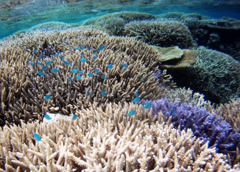
Beautiful colours on Tabu reef. anchored in 5 metres of crystal clear water and went for a snorkel. Dive boats were taking in turns using a mooring nearby. So going to use our hookahs next time we get out there.
In Port Moselle marina, leaving today. Marina busy with comings and goings. Poor HF reception as usual in the marina
Avg: 3knts
24hr: 71.7nm
Lenakel is not the best of anchorages with a large swell breaking on the nearby reef but it does have good internet, all officials in the small town and an ATM and they will do the paperwork at the weekend. Sheltered spot to put the dinghy.
Avg: 3.7knts
24hr: 90nm
7 miles from Mare Island in the Loyalties at 1.26 am. Had a counter current so have been motorsailing.
Anchored at Kuto, Ile des Pins. Leaving for Tanna today. Will have no weather info until Tanna so hope to get a sim in Lenakel if swell not too bad. Also, new BSP in Lenakel with an ATM for international cards, but have to get out before the BFH arrives.
On mooring at Ilot Maitre, cleaning hull and changing filters. Clearing customs for Tanna later this week.
Pleasant in the lagoon not too windy at Amadee yesterday. Plenty of tricot rayes on the shore.
Leaving Prony heading back towards Noumea for last minute shopping before leaving for Tanna
On a mooring at Ilot Casy. Will be heading to Vanuatu in a week or so. New plaque by the jetty in memory of Moose, the island's best known resident who died last December.
Avg: 3.8knts
24hr: 91.7nm
Hiked up to Cape Ndua, good whale watching spot but only one whale sighted in the distance.
Hiked up to Cape Ndua, good whale watching spot but only one whale sighted in the distance.
Hiked up to Mt Malaoui in Mt. Koghis, Beautiful views from the top.
Managed to rent a mooring in the bay for $5 US a night so we can do some hiking in the nearby mountains for a few days.
Took a free mooring overnight at Ilot Maitre. Turtles, snakes and bird life. It's a protected nature reserve for both marine life and birds. There is a hotel, swimming pool and restaurant
Anchored in Baie Ste. Marie. Good for supermarkets when wind is westerly. A bit bumpy now so going round into crowded Baie d'Orphelinat.
Anchored at a nice small coral islet. No whales sighted yet,
Not a particularly nice day. We passed our track for circumnavigating Le Grande Terre yesterday, Now we have to plan what to do in the next 3 -4 months. probably head to Vanuatu for a bit and then back to New Caledonia.
The clear sky has gone today. Moved to an anchorage sheltered from forecasted SW winds but no wind at present and cool.

Spent the day at Ilot Tenia in fantastic calm weather. Good snorkelling and saw the largest brown moray eel that we have ever seen before. Also a 2.5 m grey shark cruised by the boat.
Avg: 34.2knts
24hr: 821nm
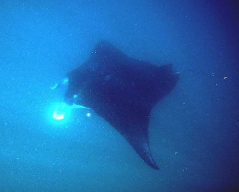
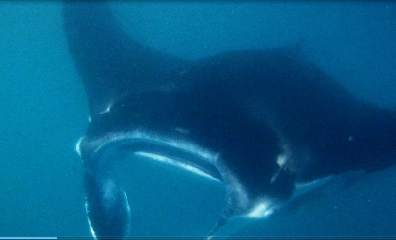
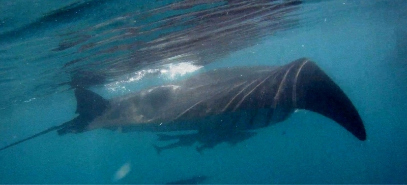
Motored a few miles down the coast to the Lepradour Channel, near Baie de St Vincente. Spotted some manta rays so jumped into the sea to take photos.They must have been feeding in the soupy current. The remoras hanging around were more bothered by our presence than the mantas!
Spent 2 nights here after winding our way through a narrow channel which has green and red beacons marking it.
Arrived in the southern lagoon at 7pm last night. Much clearer water and more marine life. Dugongs and turtles. Spent the morning at Konduyo Island. Expecting stronger winds tomorrow,


Just a short 15 mile motor sail today, wind got up to 20 knots at 10 am so not worth bashing into. Nice anchorage today and good beacons through the reefs. Navionics on android up to now has been very reliable for both depths and positions.
Anchored in Chessaloup Bay, near the village of Voh. We camped here earlier this year on our cycle trip. Beautiful calm morning. Staying here a couple of days before motor sailing further south. Wind direction and strength not very well forecast along this stretch of coast as the wind is affected by topographical features too much. Window possibly opening up at the weekend to reach the entrance to the Southern lagoon near Baie de St Vincente.
Anchored in the well sheltered Baie de Gomen after an easy 11 nm run south east from Koumac. We've started our 150 mile run to Noumea, mainly into the wind, but with day hops of 20 miles in and out of the lagoon. Heading for Voh (Baie de Chasseloup) today.
Checked into the nice well priced sheltered Koumac marina for a few days while stronger winds pass. Will probably head further south tomorrow. Going for a cycle ride today.
Anchored in Tanle Bay. Wind shadow area in these large bays and down to Koumac . Did get up to 12 -15 kn E yesterday in the middle of the day. Heading to Koumac today, 20 nm South of here.
Pleasant morning. Heading a few miles south today.
Anchored at Poum. In a wind shadow!
Anchored off the village of Poum. Plenty of pretty island and mainland anchorages around here to choose from. Gas station and store onshore and even a bus service 3 times a week to Koumac.


Anchored off uninhabited Yaba island in the north west lagoon. We have only seen 4 yachts in the last month!
Decided to round the top of New Caledonia as wind is getting up to warning level on Tuesday. There are plenty of anchorages to choose from in this area.
Nice bay with friendly locals. Moving around the northern tip today to the west coast as trade winds strengthening next week.
Sailing towards Pam on the NE of New Caledonia.
Cool morning in Hienghene. Local dive company booked up so we're going to check out the marine reserve by snorkelling.


Anchored in Hienghene. Showers yesterday, Southerlies all day(!) but hoping for better weather today, Saw a dugong tail in the bay.
At Hienghene. We don't think we are permitted to anchor in the river and the marina only has a depth of 1.2 m so we will probably hang out here for a few days and take the dinghy in.

Hoping to head to Hienghene today. On the look out for manta rays and humpbacks.
Nice morning in Touho. Back from successful negotiation with outboard warranty in Noumea.
In little Touho marina,off to Noumea tomorrow


Looks like it's going to be a nice day to go hiking in the hills around here.
Rained most of yesterday. Hoping for better weather to hike up a nearby hill. No mine site here.
Nice flat anchorage here off the NE coast of New Caledonia.
Pleasant conditions in Touho Bay. Good Internet, stores on shore. Going hiking and cycling today.
Anchored in Touho Bay on the NE coast of Grande Terre. First yachts seen for over 2 weeks. Lovely offshore weather is over for a few days.Will be here for a week, as have to bus it to Noumea.


Still haven't seen any other yachts for 2 weeks. Heading further up the coast to the small community of Touho. Expecting a wind change tomorrow night.
Sailed from Kouaoua bay to Ugue Bay. A nickel mine site on the shore but no activity at the moment. Large phone tower on the Hill.
Anchored at the head of Canala Bay, a magnificent natural harbour on the East coast of Grande Terre.
Anchored in Lavaisierre Bay. Strong thermal variation on this coast. Windy in daytime, reinforcing prevailing wind, and calm at night. Electronic charts not accurate for depths in these east coast bays. Very variable, but often deep depths with a lot of coral. Not what it shows on the charts. Heading round to Canala to day to hit the shops.
Beautiful morning on the east coast of New Caledonia in Nakety Bay. Will head further up the coast today.
Dropped into Thio to catch up with internet as the tower in Port Bouquet lost its sun with all the rain yesterday. Not a good anchorage so moving on towards Lavaissiere at midday.
In Port Bouquet in the Eastern lagoon, a quarter of the way up the east coast.
Anchored in Port Bouquet. There's a small village in the bay and a large cellphone tower on Tupeti Island so good Internet. We'll stay in the harbour for the coming strong winds and rain.


Avg: 2.9knts
24hr: 69.8nm
On the way to Port Bouquet in Grande Terre's Eastern lagoon, we stopped at deserted Onemie island .


Just left Kouakoue Bay. Quiet anchorage no other yachts in sight. No village and no road. Not enough wind to sail. Heading for Port Bouquet. Lovely anchorage.
Quiet motor through Havannah Pass. Nice, quiet anchorage here in Yate. Good internet, store up at the hydro station
Anchored in Port Boise. Heading through Havannah Pass then North to Yate today.on East Coast of Grande Terre
Anchored near old Prony village. Waiting to get round corner to east coast through Havannah Passage. Models disagreeing.Good walking in the cool weather
Nice and peaceful here but wet. May head to Port Boise later. Saw on the AIS that New Cal is soon going to be invaded by 50 plus yachts which have just left the Gold Coast in the GO East rally.
Blustery here in Baie de Prony but on a mooring in Baie Majic. Heading to Yate in a day or so.
Nice anchorage at Ouen Island.
Lovely morning in Noumea. Public holiday here today and the customs department is closed until Monday.
Heading off tomorrow to the east coast of Grande Terre via Baie du Prony.
Beautiful weather in New Caledonia.
Waiting for new passport but another public holiday on the 8th so we prob won't get off on our circumnavigation until Wednesday. All good though and plenty of nice anchorages close to Noumea. No overseas yachts here yet.
Great conditions for anchoring almost anywhere in the lagoon. May day public holiday here.
Very pleasant conditions in the lagoon. In Baie de Ste.Marie at the moment. It's May Day holiday weekend so plenty of locals out and about but no yachts seen from overseas yet. Just got to pick up our genoa from the sail repairer then we are off to circumnavigate Grande Terre. Great not to have to wait for a weather window from NZ even though conditions look more favourable for earlier departures than 2017. Had to buy a new RIB as our Turkish bought one in 2010 had more or less collapsed. We put it by the recycle bin and was gone over night so maybe it found a new owner!!!!! Fortunately, new RIBS here are cheaper than NZ.

Avg: 106.8knts
24hr: 2563.2nm
Lovely calm anchorage with beautiful views across the lagoon from the nearby hill.
Avg: 64.8knts
24hr: 1554nm
Hoping to depart the marina by the end of the week to enjoy exploring the islands in the lagoon. By the beginning of May we intend to circumnavigate Grande Terre via Havannah Pass first.
Just arrived back to Saraoni after leaving it for 10 weeks in Port Ouenghi Marina while we cycled in Tasmania and to Adelaide in South Australia. . No damage after a close call with 2 cyclones.
Getting ready for the cruising season and no NZ weather window to worry about.
Saraoni is in New Caledonia but we are in Tasmania on a cycling trip. Currently in Richmond cycling to Triabunna tomorrow.
Saraoni all trussed up in the Port Ouenghi marina while we fly to Hobart for our Hobart to Adelaide cyclathon. Limbered up with a 600 km cycle ride around Grande Terre, Boulouparis to Hienghene via Koumac and Pouebo. Rain stopped play in Hienghene as the SPCZ came south.
For those who have met Moose, the Casy Island abandoned dog, he died not long after we saw him in Baie du Prony before Christmas. Nice YouTube video by South Africans on catamaran Impi as a tribute. https://www.youtube.com/watch?v=P93qEEXcu3U, worth watching!
Just returned from a 4 day hike following New Caledonia's GR 1 or Great Walk. 2 of the days we saw no-one. Lots of clambering up and down valleys and across rivers and streams. Maximum height gain on one day was 1200 metres. Lots of amazing kaori trees related to the NZ kauri. See blog address below if interested.
http://www.sailblogs.com/member/saraoni/
No blogs available for this yacht.