Taranui
Avg: 5.1knts
24hr: 123.3nm
4.4 knots, 127 tue 629 miles to run to Picton all well
Avg: 4.9knts
24hr: 117nm
736 Miles to run ETA Friday
all well
Left Lord Howe for Picton about 880 miles run
all well aboard.
Moored atLLord Howe looking at weather for tasman crossing to Opua all well..
On mooring through Man of War Pass underneath towering sheer faced Mt Gower (875 m). Stunning destination!
Well done. Glad you're in
Avg: 3.6knts
24hr: 85.5nm
Hove to waiting to enter Lord Howe Island, all well,
departure for New Zealand weather dependant.
Avg: 4.9knts
24hr: 117.9nm
ALL WELL ABOARD 68 MILES to Lord Howe island
Fantastic that some kind
SOUTHPORT TO LORD HOWE 282 MILES TO RUN
ALL WELL
After returning from a ten day inland trip left Sovereign island and anchored on northern side of Wave-break Island. Nice beach and warm water!
Snug Taranui up in Sovereign island to begin 10 ten day inland National Parks trip in northern NSW.
26 NM beaut downwind sail (jib only) weaving through the shallows back down to Tipplers. Last hour in dark.
Nice 24.6 NM warm downwind sail from Tangalooma to Horseshoe Bay, Peel Island.
30.3 NM from Brisbane to Tangalooma yesterday afternoon with outgoing tidal stream. Anchored between wrecks and beach.
32.7 NM onward and we are up the Brisbane River right in the city.
Wild unsettled weather over past few days and more to come. 4.2 NM from Dalpura Bay, Macleary Island to Coochiemuldo Island for a change of scene and an even more secure anchorage from the southerly winds.
Moved 5.4 NM to Dalpura Bay on Macleay Island to shelter from forecasted SE. Beautiful Island!!
Back to Horseshoe Bay, Peel Island
2.8NM over to Dean Billa Bay, Dunwich on North Stradbroke Island. On the bikes today to Point Lookout and Amity Point. 50km
10.6NM northward from Karragarra Island to the popular south side of Peel Island (Horseshoe Bay). The Island is also a Conservation Park (Teerk Roo Ra) and was also a Leper Colony with some historic remains. Having seen a Dugong and sea turtles feel we are on the periphery of the tropics. Water temp; 20 degrees cel.
9.6 NM further north from Jacobs Well in the Gold Coast Seaway to Karragarra Island.
After anchoring in 'Bums Bay' for a few days to restock headed 14.4 NM northward through the Gold Coast Passage to Jacobs Well. Pete Brady on board who cycled back home at the Gold Coast.
Motored Taranui 1.4NM from its two week primo berth on Sovereign Island, while we were in NZ, to Paradise Point.
6 NM to The Sovereign Mile, Sovereign Island to put Taranui in a 'holiday home' while we fly to NZ to catch up with Charlotte at Whakapapa , NZ.
3.6NM back toward Southport to Tipplers. A huge camping area and resort. Beaut walk through forest to east coast.
3.4 NM back from Slipping Sands to Jump Pin Lagoon. Very tropical.
3.5 NM at near high tide into the very shallow Canaipa Passage to Slipping Sands anchorage. Down to 0.1 metres (10 centimetres) under the keel. Excellent shelter from the fresh northerly.
Ventured 13.6NM northward through inland waterway to South Stradbroke Island just south of Jumpin Pin bar. Anchored here November 2016 on way south.
Pleasant sailing from Iluka to Southport. 101NM. Arrived in 'Bums Bay, Southport 4am this morning.
Early start from Coffs Harbour to reach Iluka (Yamba) in good time. 59.3 NM. Plenty of whale sightings, breaching, spy hopping, pectoral and tail flapping.
36.4 NM northward from Trial Bay to Coffs Harbour.
Overnight in Trial Bay en-route to Coffs Harbour. 38.6 NM today from Port Macquarie. Still plenty of whales heading slowly north as we are.
Moved from rented mooring to courtesy mooring.
31.2 NM from Crowdy Head to Port McQuarrie.
Early start for the 57.3 NM sail northward to Crowdy Head. Joined the conveyor belt of Humpback and Southern Right whales heading northward at a similar speed to Taranui.
3.9 NM to Esmerelda Cove on south side of Broughton Island.
11.7 NM sail northward from Shoal Bay, Port Stephens to Providence Beach, north side of Broughton Island
After being in Nelson Bay for two nights for fuel, water, supplies and bike ride up Gan Gan lookout, Boat Harbour, Anna Bay and Salamander have anchored at Soldiers Point for protection from the imminent strong westerly's. All settles down again tomorrow.
Navigated Taranui carefully through the shallows of the Myall River entrance. Beautiful anchorage close to Winda Woppa surrounded by Pelicans, numerous other wading birds, sand dunes and mangroves.
Delightful Fame Cove after a short slow moving sail from Taniba Bay in Port Stephens.
5NM around other side of peninsula to explore Taniba Bay

After cycle to Fingal Bay motored further into Port Stephens to Tilligery Creek close to Lemon Tree Passage.
Moved around corner to Nelson Bay for supplies and laundry.
Avg: 2.8knts
24hr: 67.8nm
3am start to cover the 75.2NM from Fishermans Beach, Broken Bay to Shoal Bay, Port Stephens. Sighted a number of humpback whales migrating north, but none of the 84 containers lost overboard a few weeks back in this area. Harder to sight as they don't spout!!
Moved to Fishermans Beach for a change of scene and closer to Broken Bay entrance ready for departure north.
Motored 12NM into Jerusalem Bay in preparation for a walk on the Great North Trail tomorrow.
Up into McCarrs Creek to meet up and dine with couple on yacht Azimba. Very tranquil and scenic. But as you can see we are not the only vessels up here!!
22.6NM from Balmoral, Sydney Harbour to Coasters in Pittwater. No longer Sydney Siders!!!
Avg: 65.1knts
24hr: 1561.4nm
Back up to Cabarita after a very interesting day on Cockatoo Island.
Anchored off Hunters Hill Sailing Club in the Parramatta River as a convenient spot to access Sydney Harbour's largest Island - Cockatoo Island. Steeped with ship building history and has National Heritage.
Chowder Bay for a change of scene.
Back out to Rose Bay ready to walk the coastline between Bondi and Cooge.
4.2NM further up-river to Cabarita to launch the bikes for the Paramata cycle trail and the Olympic Park.
4.5 NM up river to Lane Cove for a snoop around Woolwich and walk on a part of The Great North Walk.
Back to Black Wattle.
3 NM to Balls Bay to access a walk.
5 NM under Harbour Bridge and Anzac Bridge and through the now unused Glebe Bridge and into Black Wattle Bay for easy access to 'Vivid Sydney'.
21.8NM run from Coasters Retreat back into Rose Bay, Sydney Harbour to experience Sydney's Vivid Light Festival. The Sydney Harbour Bridge is in "bling" and beaming powerful laser beams in different directions. All seen from our Rose Bay courtesy mooring.
Careel Bay for a change in scene and a walk.
Moved to Morning Bay, Towlers for social dinner on yacht Kimbo.
Avg: 10knts
24hr: 240.7nm
Moved 1NM across to the delightful Coasters Retreat.
11.1 NM from Cotton Tree Bay to Palm Beach in Pittwater for a walk up to the iconic Barronjoey Lighthouse. Observed a bit of "Home and Away" filming!
Just a 1.5 NM shift back up the Cowan Creek to Cotton Tree Bay with a magnificent fringe of sandstone bluffs and bush.
6.5 NM from Jerusalem to yet another beautiful anchorage at Bobbin Head in Cowan Creek..
6NM from Smiths Creek to Pinta Bay in Jerusalem Arm for a change of scene and another walk.
A further 5.6NM ingression into Broken Bay to the head of Smiths Creek and it is absolutely tranquil, peaceful and stunning. In the midst of Ku-Ring-Gai Chase National Park.
27.8 NM from Ball Head Bay, out through Sydney Harbour Heads and north along the coast to Refuge Bay in the greater Broken Bay. NSW's answer to NZ's labyrinth of waterways; the Marlborough Sounds.
Moved to quieter Balls Head Bay.
Avg: 110.9knts
24hr: 2662.1nm
Back in Black Wattle Bay in prep for Charlotte's departure early tomorrow morning.
Stop off at the beautiful Camp Cove for final swim and sun soak with Charlotte before she departs tomorrow.
Into Manly Cove to take Charlotte out for a meal.
2.4 NMN across from Quarantine to Balmoral for the day.
Moved back out to Quarantine Bay, Manly for a bit of beaching, swimming and walking North Head.
Moved to Sugar Loaf to access some different walks. Happy to be in the very sheltered Middle Harbour while a frontal system passes. This one gave Tasmania a bit of a hammering.
Into Bantry Bay, Middle Harbour from Store Bay for protection from westerly. Bridge to enter opened at 8.15pm hence some careful night navigation. All went well and worth it.
Into Black Wattle Bay in prep to pick up Charlotte at airport.
Avg: 77knts
24hr: 1848.6nm
Overnight move for shelter in Rose Bay from predicted SW. A blow is passing over for a short while. Will move back to Manly tomorrow morning.
On courtesy mooring for a few hours in Manly Cove to enable easy resupplying.
19.7NM from Port Hacking to Store Beach, Manly in Sydney Harbour. Gorgeous motor sail close to the scenic coast past Botany Bay, Bondi Beach and South Head into Manly.
72.7NM, 13 hours pure sailing from Jervis Bay to Jibbon Beach, Port Hacking. Anchorage backs on to Royal National Park. Only 18NM from Sydney Harbour Entrance.
Avg: 7.6knts
24hr: 181.6nm
Arrived at Jervis Bay 2130. Calm anchorage and catch up on sleep after busy and challenging 330 NM sail from Babel Island - 64 hours.
Avg: 6knts
24hr: 142.9nm
Off the Red Cliffs lighthouse, Eden. Boxing on!
Avg: 13.1knts
24hr: 314.7nm
Uncomfortable sailing in Bass Strait. One poop over stern.
Out through the Pot Boil again from Franklin Sound then north to Babel Island.29NM.
24.9NM from Jamieson Bay to Lady Barron in Franklin Sound (Between Cape Barren and Flinders Islands). Passed through the notorious Pot Boil.
Avg: 11.1knts
24hr: 267.5nm
22.8NM from Spike Cove to Jamieson Bay on East Coast of Cape Barren Island, Furneaux group.
46.8 NM from Binalong to Spike Bay, Clarke Island in the Furneaux Group. This Bay is surrounded by spectacular natural granite rock landscaping.
59.9 NM from Wineglass Bay to the beautiful Binalong. Visited here by road about a month ago. Had some pure sailing today.
Early start to Wineglass Bay (11.5NM) before the predicted northerly "kicks in". Decision to tack into the northerly today or "chill out" in Wineglass and motor sail in the variables tomorrow. Opted for the latter!!
Taken advantage of the dying SW (was 50knots) to get to Schouten Passage to begin the hopping voyage to Sydney after 1 year and 2 months in Tasmania. Anticyclonic weather on the way. 26.8 NM today without burning diesel.
Into Triabunna for four or five days while the wild weather passes and while we head into Hobart by land with Hilary's sister who departs Wednesday. Then await a weather window to start sailing north to Sydney.
Into Triabunna to land trip into Hobart for a few days with Sarah who fly's out of Hobart on Wednesday. Then we await a weather window to start heading north to Sydney.
A gnarly beat into the southerly for a large proportion of the 28.9 NM's from Schouten Passage, Freycinet to Prosser Bay for shelter from the upcoming unsettled weather.
30.3 NM sail from Shoal Bay, Maria Island to Passage Beach in Schouten Passage. Re-anchored in Bryans Corner later in day.
Avg: 169.6knts
24hr: 4070.5nm
From Fortescue Bay to Shoal Bay, Maria Island stopping at North Bay en-route to walk northward to Tasman Bay where Abel Tasman landed in 1642. First white people to land in Tasmania. Total of 34 NM today.
Anchored in to North Bay and walked over to the monument in Tasman Bay. Abel Tasman landed here in 1642; the first white people to land in Tasmania.
17.8 NM passage from Port Arthur to Fortescue Bay. Anchored behind wreck in Canoe Bay. Mirror calm.
53.6NM from Deep Hole, Southport to Port Arthur via east side of Bruny Island.
11.2NM from Port Esperance to Southport.
From Deep Bay to Port Esperance for festival. 10.6NM
From Randalls Bay to Deep Bay.4.6NM
Avg: 27.3knts
24hr: 656nm
17.7NM Missionary Bay to Randalls Bay. Anchored in Isthmus Bay opposite The Neck en-route. Lookout and walk on Adventure Bay beach.
Duckpond to Missionary Bay. 9.2NM
24.4NM from Lagoon Bay to the all-round shelter of Duckpond on Bruny Island ready for the prospective SW 40knots tomorrow. There may be a few ruffled feathers in the pond!!
From Connellys to Lagoon Beach. 5.7NM. Now 3 POB. Hilary's sister Sarah with us for a few weeks.
Departed Dunalley at high water to pass through the Denison Canal and anchor at Connellys Bay. 5.7NM.
Departed Prosser Bay 0400 and passed through the Marion Narrows at 0730 and onward to Dunalley mooring. 24NM. Aurora Australis entertained us for a short while. Renting car and taking mountain bikes to Derby in the NE. Derby is becoming world renown for mountain biking.
Sail from Schouten Island to Triabunna for fuel and water (26.7NM) then to Prosser Bay (3.8NM). Very early start tomorrow morning (0400) to catch high tide at Marion Narrows to then head to Dunalley.
Shuffled across Schouten Passage from Bryans Bay to Crockett Bay for southerly wind shifts.
13.2 NM pleasant sail from Wineglass Bay to Bryans Corner, Schouten Passage.
Avg: 3.6knts
24hr: 86.1nm
72NM fast motor sail from Eddystone Point to Wineglass Bay. Stunning day.
Beaut sailing on slight sea through Banks Strait between Foster Inlet and Eddystone Point. 37.1NM
Early start to catch the tidal stream for the 17.2NM sail from Water House Island to Foster Inlet west of Banks Strait.
52NM sail from West Arm, Tamar River to Water House Island.
Great sailing from Stanley back to West Arm in the Tamar River. 80NM.

Yesterday - 84.8 NM sail from Sheep Tail Point, Tamar River to Stanley beneath "The Nut".
Just another 3.6 NM further down the Tamar River to Sheep Tail Point for protection from the SE.
14.1 NM downriver from Freshwater Point to Batman Bridge. Stopped at Windermere en-route for another pick of wild black berries.
Avg: 6.3knts
24hr: 151.6nm
After exploring the Tamar Island Wetlands travelled a further 2.3 NM to Freshwater Point. Very relaxing this river-boating!
4.7 NM down river from Launceston, anchored to visit the Tamar Island wetland walk. Another of Tasmania's Great 60 Short Walks. Excellent.
The final 13 NM up the Tamar River into the Launceston Basin. On Tamar Cruises dock adjacent to the Royal Park. Nice piece of real estate.
A further 8.3 NM upriver (Tamar) early this morning to catch last of incoming tidal stream. Anchored at picturesque Windermere.
11.8 NM further up the Tamar River from George Town and just after passing under the Batman Bridge, Taranui is anchored in tranquil Newmans Bay.
Shifted a short distance to York Cove at Georgetown. Debagged the bikes to ride out to Low Head and the Pilot Maritime Museum. Stories of ship wrecks, piloting, communications and more. Very well presented. Conveniently on public pontoon in Georgetown.
Avg: 3.3knts
24hr: 78.6nm
Weighed anchor at 0300, East Kangaroo Island to sail 81.2 NM to West Arm, Tamar River. Exciting sailing up the River on incoming tide; 10 knots SOG! Will be a flat, tranquil anchorage tonight to catch up on some ZZZ's!
30.6 NM sail from Killiecrankie southward to Kangaroo Bay. Between 6 and 7.5 knots. Plan is to hitch a ride on tomorrows NE wind conveyor belt to the Tamar River on the Tasmanian mainland's north coast.
11.6 NM from Roydon Island to Killiecrankie. Magical!!
Just sail cruised for 8.3 NM on the run with jib alone at between 2 and 3 knots to Roydon Island. Beautiful and tranquil!
20.9 NM fast sail to Port Davies on Flinders Island from Badger Island. Large swell for first half before the protection of Prime Seal Island due to the overnight 30 to 40 knot SW.
11.7 NM pleasant sail to Badger Island for protection from the forecasted southerly change.
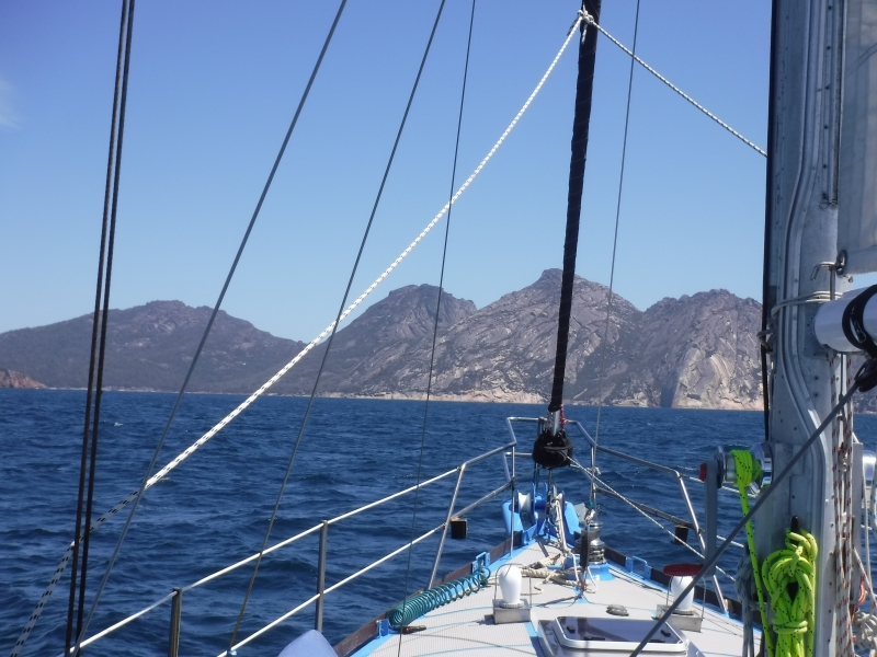
24.8 NM sail from Spike Bay to Trouser Point on Flinders Island. This anchorage is stunning with the Strzelecki Peaks bearing down on us. Clear water and beautiful beaches.
33.4 NM sailing between Eddystone Point and Spike Cove, Clarke Island in the Ferneaux Group, Bass Strait. Assisted by a 2 to 3 knot tidal stream.
Avg: 2.9knts
24hr: 70.7nm
72.2 NMN today from Wineglass Bay to Eddystone Point. Anchored beneath the Eddystone Lighthouse built in 1889.
Avg: 2.6knts
24hr: 62nm
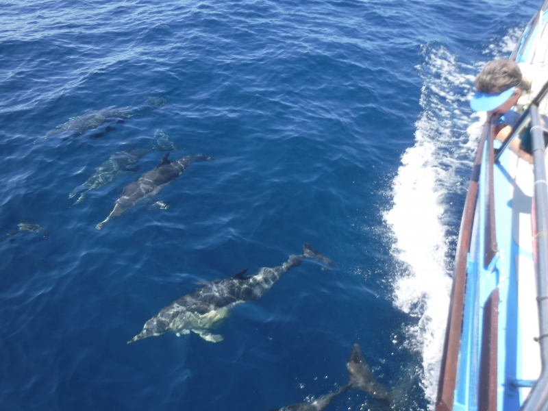
1645 and 60 NM on the passage between Wineglass Bay and Eddystone Point.12.7 NM to go. Off the entrance to St Helens. Motor sailing at around 6 knots. Although not much pure sailing it is a perfect day. Plenty of Common Dolphins to keep us amused.
12.4 NM from Bryans Bay, Freycinet Peninsula to the infamous Wineglass Bay. The Hazards are bearing down on us. This was our first landfall in Tasmania February last year.
36.8 NM from Shoal Bay, Maria Island to Bryans Bay, Freycinet Peninsula. Passed close by to Isle Du Phoques to observe hundreds of seals. Also diverted to check out Hen and Chicken Bay on the southern coast of Schouten Island. Dramatic, narrow and a roll running in. Fancied a good nights sleep so vacated and headed for Bryans Bay.
32 NM from Slopen Main, through the Dennison Canal for the fourth time and on to Shoal Bay on Maria Island. Caught two Flatheads and one squid (Calamari) en-route for dinner. Beautiful sail between 5 and 7 knots. Taranui is responding to her recent anti foul.
29.3 NM from Kettering to Sloping Main in Fredrick Henry Bay. Boat speed between 6 and 10 knots. Taranui much happier now after her "bum cleaning"!
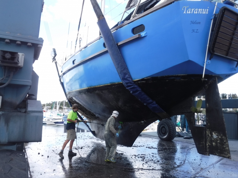
Hoisted up on hard-stand yesterday at Kettering. Anti-foul, replace anodes and have fitted new through-hull transducer. Last haul-out was in Whangarei 21 months ago.
37 NM yesterday from Dunalley through canal. Short stop-over at Lagoon Bay before heading to the Duckpond. Arrived approximately 2100.
From Shoal Bay to Dunalley stopping en-route to catch a few Flatheads for dinner. 18.1 NM. Bike ride to Marion Bay tomorrow morning before passing through the canal at high water approximately mid-day.
South end of Shoal Bay, Maria Island
No blogs available for this yacht.
Sounds like a good trip so