The Southern Cross
Avg: 2.7knts
24hr: 64.6nm
Departed Spalding Cove, near Port Lincoln on Monday morning. Travelled non-stop through to North Haven Marina, in Adelaide. The 155 nautical mile trip took 32 hours. Just as we were coming into the marina, the steering cable broke. We narrowly missed hitting the breakwater on the port and then on the starboard side as the boat veered out of control. Anchored in the middle of the entrance while a temporary repair was done, enabling us to enter the marina safely. After 10 and a half years The Southern Cross is back in her home port. We are grateful to Kath and Rod for their assistance and warm welcome. A big day for us, our ninth grandchild Addison Faye was born this morning here in Adelaide.
Departed Port Lincoln this morning and popped back to Spalding Cove for this evening.
A pleasant 7 nautical mile sail under jib on flat water from Spalding Cove to Port Lincoln. Anchored off the town and looking forward to buying bananas.
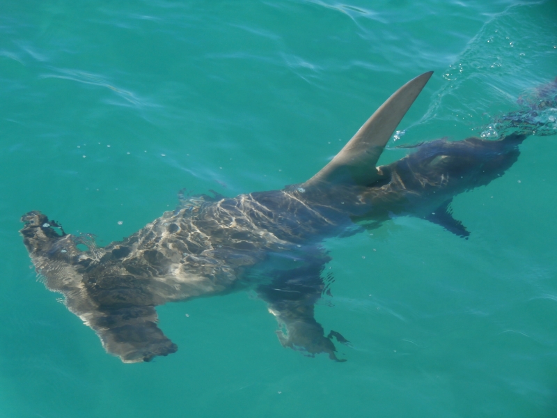
Pleasant sail under jib on flat water from Williams Island to Boston Bay. Now anchored off Spalding Cove, approximately 5 nautical miles east of Port Lincoln. Last time we anchored here was in February 2007. A good place to rest; lovely still water beneath the boat.
NB We picked up a sunken mooring on our anchor. So best not to anchor in exactly this spot.
Congratulations on an epic
Anchored in the shelter of Williams Island, which lies off the southern tip of Eyre Peninsula, near Cape Catastrophe. Instead of contending with large lumpy seas, we are sitting on gently rolling waters. It is a relief to have crossed the Great Australian Bight. We are five miles away from completing our circumnavigation of mainland Australia. Plan to raise the anchor later this morning and head towards Port Lincoln.
Avg: 7.1knts
24hr: 170.4nm
Bouncy seas continue. Some blue sky can be seen through grey clouds. Landfall not far off now. All is well on board
Avg: 7.8knts
24hr: 186.9nm
Bouncy sea with up to 2 metre swells coming from 3 directions. Reefed down for the night with three reefs in the main and the jib. A uncomfortable sail. All is well on board.
Avg: 7.5knts
24hr: 179.2nm
Bouncy sea with up to 3 metre swells coming from 3 directions. Three reefs in the main and a partially furled jib. A very uncomfortable sail. All is well on board.
Oh, how many times does the
Avg: 5.2knts
24hr: 123.9nm
Comfortable motor-sailing on long period swell. All is well on board.
Departed Arid Bay, Cape Arid this morning (Sunday 12 November). Now clear of the Recherche Archipelago. Seas 1 to 2 metres. All is well on board
Still anchored in Arid Bay, Cape Arid waiting for a weather window to head across the Great Australian Bight. Went for a hike today. The scenery is spectacular. The sand is fine like icing sugar, but firm when wet which makes for great walking along the beach.
Sailed eastward from Lucky Bay to Arid Bay, Cape Arid in vigorous easterlies. We put in 16 tacks to sail 75 miles, and travelled 46 miles as the crow flies. Enjoyed beautiful scenery along the way and, after nearly 14 hours at sea, the delight of finding a safe haven just as the sun was setting.
3 hour sail from O'Briens Beach at Cape Le Grand to Lucky Bay, which is 7 miles east as the crow flies or 15 miles when you are tacking into the wind. And what a pretty spot this is, aquarmarine seas roll onto pristine beaches and lap around rocky outcrops.
Avg: 5.9knts
24hr: 142.1nm
48 hour sail from Albany to O'Briens Beach at Cape Le Grand, which is approximately 12 nautical miles east of Esperance. A good passage with wind on the starboard beam most of the way. We seemed to have helpful current with us for the last 24 hours. Maximum depth 3,000 metres. Saw many albatross and shearwaters. On approach to the anchorage we saw surf exploding over rocky islets and reefs of the Archipelago of the Recherche.
Spent five days in Albany, enjoying the scenery and friendly locals despite gale force winds on Thursday and Saturday. Departed yesterday (Monday) afternoon. Currently headed towards Esperence. Exact destination to be determined. Relatively easy conditions. All is well on board.
Avg: 4.3knts
24hr: 102.8nm
Arrived Albany at 6pm WST last night. From Cape Leeuwin it was a comfortable fast ride on winds from astern: 20 to 30 knots, gusting to 40 with seas up to three metres. With only a scrap of jib out we surfed down one wave at over 16 knots. Saw a number of birds including albatross. Plan to stay in Albany for a few days while gales rage.
Avg: 2.9knts
24hr: 68.9nm
Departed Bunker Bay this morning. Travelled southwards from Cape Naturalite to Cape Leeuwin through a stretch of water called 'Other Side of the Moon' on our chart. Rounded Cape Leeuwin this afternoon and we are now in the Southern Ocean for the first time since 2007. Smooth sailing on 2 metre seas. Destination is Albany. All is well on board.
Departed Geographe Bay late this morning. Pleasant sailing on flat water. Now tucked up in Bunker Bay, near Cape Naturaliste. Whales breaching nearby. Planning to round Cape Leeuwin tomorrow.
Spending time with old cruising buddies has made our stay in the Busselton area very special.
Another fabulous sail, this time from Bunbury to Port Geographe, near Bussleton. Sailed at 7 to 9 knots and covered 26 miles in 4 hours.
Great to follow your trip,
Avg: 2.6knts
24hr: 61.3nm
A delightful sail from Mandurah to Bunbury on flat water. Sailed 50 nautical miles in seven hours; maximum boat speed was 10 knots. It is the best sail we've had in a long time. Heading off to catch up with friends, who live in Bunbury: we first met them in Darwin and last saw them in the Kimberley.
Had a walk around town, and then took the boat back downstream outside the entrance to the Mandarah canal. Currently on a courtesy mooring, ready for an early departure tomorrow. Rolly conditons.
Berthed at a visitor jetty in the heart of Mandurah, after a pleasant 32 nautical mile sail.
After two weeks of Freo Fun we departed the Fremantle Sailing Club this afternoon and travelled four nautical miles southwards to Owen Anchorage, Woodman Point. Heading towards Geographe Bay over the next few days.
At last we are in Fremantle, Perth. Yesterday morning The Southern Cross departed Boullanger Island, near Jurien. A relatively easy 120 nautical mile trip, with fast sailing at the beginning, and then some motoring to ensure we arrived well before the strong southerlies filled in. Feels wonderful to be here.
Yesterday The Southern Cross was tied up to a concrete jetty within the Jurien Bay harbour. It was a 40 minute walk to the IGA and town along the foreshore. Went for a walk along a beautiful beach this morning, which is just north of the marina. Visited the very friendly Volunteer Marine Rescue service and was given information about the southern passage, which will be helpful when we depart for Perth in a few days. Currently at anchor off Boullanger Island, just off Jurien, which is providing us with good protection from strong southerlies. Hope to leave Sunday for Fremantle, near Perth.
Due to a series of gales on the southern Western Australian coast, The Southern Cross was berthed at the Batavia Coast Marina, Geraldton for 11 days. We had hoped to sail right through to Perth, but took a 28 hour weather window and travelled as far as Jurien Bay. Hope to leave for Perth in the next few days, after more strong southerlies blow through.
Avg: 4.1knts
24hr: 98.1nm
Departed Turtle Bay, in Shark Bay at first light on Thursday and took two days to travel 210 miles to Geraldton in calm conditions. Arrived this morning and are berthed at Batavia Coast Marina. Enjoyed a hot shower, a visit to the museum and a short walk to Coles. Will be here for a few days.
Sailed from Monkey Mia to Turtle Bay, on Dirk Hartog Island. Hope to leave soon for somewhere further south, perhaps Geraldton.
An easy 18 nautical mile motor sail from Herald Bight to Monkey Mia on Fridy 8 September. We are at anchor off the Monkey Mia resort with a dozen boats, including friends on Wyworrie. This is a cruiser friendly place with small convenience store, restaruarnt, rubbish bins, laundry and showers. Lots of wildlife seen: dolphins, shovel nosed sharks, reef sharks, sting rays, turtles, pelicans, sea eagles, seagulls, swallows, snakes and emus. Dinghied to the 'shark nursery' yesterday near Rose Bluff, which was alive with sharks in shallow water. Walked up Rose and Red Bluffs. Will be here a few more days; more strong southerlies on the way.
Avg: 2.6knts
24hr: 61.4nm
Gnarraloo Bay to Shark Bay - this is a trip that we will long remember. Left Wednesday morning in calm weather with a reasonable forecast for an overnight trip. All good till 4.30pm when thunderstorms hit, and continued to rain on our parade for 10 hours. Lightning flashed around us, rain pelted down and up to 33 knot winds besiged us. Hove to and had a relatively comfortable ride until the storm passed. The Southern Cross is now anchored in Herald Bight. We have been transported to a heavenly place where there is no wind, no rain, flat seas and all is well.
Sailed and motor-sailed from Coral Reef to Gnarraloo Bay, along Ningaloo Reef. Covered 50 miles in 10 hours. Some swell coming into this anchorage. Crossed out of the tropics while on passage. This is a very beautiful bay.
Sailed from Tantabiddi to Coral Reef, along Ningaloo Reef. We departed at 2am and took 13 hours to travel 80 nautical miles. A sporty sail with winds peaking at 25 knots and boat speed at 9 knots. Swell was up to 3 metres, before dropping during the afternoon. Went for a quick snorkel here, clear water, lots of fish and some nice bommies.
Moved within Tantabiddi anchorage, Ningaloo Reef to gain better protection from the strong south-westerlies that blow through in the afternoons. Holding on this side of the bay is not great. After seven attempts we found a patch of sand. Went for a snorkel over the extensive reef yesterday afternoon. Lots of healthy corals. Three other cruising boats and lots of tourist boats on this side of the anchorage.
Avg: 2.7knts
24hr: 65.8nm
Left Serrurier Island before dawn and sailed on lumpy seas to North West Cape. In the lee of the land we had a wondeful sail on flat water until the wind died and then on with the motor for the last seven miles. Just before turning into the Tantabiddi anchorage we saw two whales nearby; and watched the youngster at play with mum keeping a close eye. They kept us company for nearly half an hour. The wind has increased since we arrived; instead of snorkelling we are on anchor watch as the boat bounces up and down in one metre seas.
Yesterday sailed and motor sailed from the town of Onslow to Serrurier Island. Seven hours to come 26 nautical miles, with current against us most of the way. Today we walked along the beach and saw about 20 turtles in the water, mating and coming ashore. Snorkelled over excellent corals with a plethora of fish. The best coral we've seen since returning to Australia in November last year.
Anchored off the town of Onslow last night. Quiet night in terms of a flat sea and no tidal rip, noisy in terms of the nightlife which continued through to dawn.
Went ashore this morning and left dinghy near the boat ramp. Short walk to corner of Second and Third Avenues where there was a well stocked supermarket and a petrol station straight across the road. Both are open seven days a week.
We continue to see many, many whales while underway. Saturday morning, just before dawn we met seven sleepy humpbacks, fortunately bumping into none.
We left the beautiful Montebello Islands this morning and sailed southwards 40 miles to the Passage Islands, which are just off the Western Australian coast. Now anchored in the lee of South Passage Island. We hope to move further south tomorrow. We saw plenty of whales while underway with two very close encounters. The first was in 6 metres of water, where mother and baby dived beneath our hulls. And later in the day a mother, baby and adult male missed us by a metre.
Moved at high tide from Chianti Bay, Alpha Island to Mansion Bay, Hermite Island. Only 5 miles. Yesterday evening we were visited by a 3 metre hammerhead shark who circled The Southern Cross looking for a feed. The shark had a blue stripe on its fin, courtesy of our antifouling.
Yesterday at high tide we moved through narrow passes between rocky outcrops to Chianti Bay, Alpha Island from Main Beach, Trimouille Island, all within the Montebello Island Group. Very pretty scenery. Went for walks on the beach. Four other vessels in this area; we've enjoyed meeting other boaties.
Avg: 2.6knts
24hr: 62.4nm
Departed Eaglehawk Island, Dampier Archipelago at 0200 this morning. Motored in no wind till daylight and then sailed in 15 knot easterlies on one metre seas. Entered the Montebello Island group between Dot and Daisy Islands. Currently anchored off Main Beach, Trimouille Island. This afternoon walked for kilometres along a beautiful beach at low tide.
1800 WST. Motored in no wind and then sailed in a light northerly, from Enderby to Eaglehawk Island, Dampier Archipelago. Easy day, only 7 miles. Went ashore and walked along the eastern beach which had interesting rock formations to the wreck of a ship. Weather looks good to head off early tomorrow for the Montebello Islands.
Departed Hampton Harbour, Dampier yesterday morning. We left behind the red dust, friendly locals and access to shops. Tacked into head winds, which were up to 20 knots apparent at times for the 10 nautical mile trip. Anchored off Enderby Island, in the Dampier Archipelago.
Plan: to anchor off Eaglehawk Island this afternoon in readiness to sail to the Montebello Islands tomorrow, weather permitting.
Hi Catherine, hi Peter!
Monday evening. Moved to Hampton Harbour, Dampier yesterday morning. Lots of friendly people here and the local sailing club is exceptionally welcoming. We are lucky to have a local contact and are grateful to Terry, who drove us into the town of Karratha where we were able to buy bananas and lots of other fresh food. After two months without shops our cupboards were bare.
Avg: 10.2knts
24hr: 245.5nm
2020 WST. Currently anchored off Angel Island, 10 miles north of Dampier, after a two day voyage from Rowley Shoals. We saw lots of marine life while underway: dozens of whales, two sea snakes, pod of dolphins, sea birds, flying fish and a turtle.
1700 WST. We enjoyed our two day at Clerke Reef; good snorkeling and a beautiful sandy islet with red tropic bird population. Departed at midday, came through the narrow channel and there was a whale at the entrance again. Have had to tack 5 times since departure, traveling 17 miles but only 8 towards our destination. Now just south-east of Clerke Reef and sailing on a course for Dampier.
1630 WST. Sailed from Mermaid Reef this morning. Arrived at Clerke Reef at noon, which was high tide. Just on approach to reef entrance we had a whale breaching in front of us, which added to the excitement and degree of difficulty. Very glad that we had a calm day with good visibilty to enter through this narrow pass. Snorkeled at the 'aquarium' this afternoon; saw a plethora of fish, a few white tipped reef sharks and some very good coral.
1630 WST. After a two night sail we arrived this morning at Mermaid Reef, part of Rowley Shoals. Came through the pass at high tide in good light and picked up the mooring we had booked. At high tide there was a bit of swell coming across the reef. Now it is low tide and it is much calmer. Had a wonderful snorkel over some bommies. Clear water, lots of fish and healthy coral. Wore wetsuits. Having fun.
Avg: 4.7knts
24hr: 112.8nm
1500 WST. Travelled 100 miles since leaving Lacepede Islands. Sailing slowly under a reefed jib aiming to arrive at Mermaid Reef in daylight hours tomorrow.
1500 WST. Departed Beagle Bay this morning. Sailed, then motor-sailed to West Island, in the Lacepede Islands. Saw whales, tail slapping and breaching while underway. Day anchorage at West Island to see this wonderful nature reserve. It is home to the largest green turtle rookery on the west coast of Australia. We saw lots of turtle tracks as well as turtles mating in the water. Also saw brown booby birds, frigates and terns. At 1700, underway again, headed westwards for Rowley Shoals.
1800 WST. We came into Beagle Bay to hide from the forecast strong winds. The wind found us. Over 40 knots yesterday morning and up to 39 knots this morning. We are anchored away from the shore, due to shallows, therefore there is a long fetch and we had up to 2 metre seas, quite uncomfortable although always safe. Plan to head towards Rolley Shoals tomorrow.
Sailed 40 miles from Cape Leveque to Beagle Bay yesterday. Wind gradually decreased during the morning from 25 to 30 knots at 6am, down to 10 knots when we arrived at 3pm. Over the day we saw 10 whales: we had to change direction to miss colliding with two of them; two others put on a fine performance, tail slapping for 10 minutes. Beautiful coastline. There is a pearl farm in Beagle Bay, well marked with reflectors. Very cold this morning, down to 19 deg Celsius. Will wait here a few days as strong winds are forecast for tomorrow.
Avg: 4knts
24hr: 96nm
Report at 1830 WST. Moved the boat back into deeper water this afternoon. Pretty spot, friendly fisherfolk, great sunsets over Cape Leveque. Dinghy access to the beach is better at low tide when the reef blocks the swell.
Anchored in one metre of water at low tide near the area where people beach launch their fishing boats. Only a quick stop to go under the boat to check the props. We were advised by the locals that this was the best place to get in the water, no crocodiles and in shallows away from the tiger sharks. Hulls look good although lots of barnacles on the props.
Avg: 43knts
24hr: 1032nm
Returned to Cape Leveque this morning as there is no wind to sail to Rowley Shoals for the next few days. Had a lovely meal ashore at the Kooljaman Restaurant. First salad vegetables we've had for weeks. Were able to purchase half a dozen eggs for $6 but they had no bananas.
Were able to purchase four jerry cans of diesel. They took our cans and had them filled while we ate lunch and then drove us back to the beach and helped launch the dinghy in the surf. Fantastic service.
Report at 2000 WST 26 July 2017. Sailed 10 miles in 10 hours from Cape Leveque. Ran out of wind and tide so anchored in roadstead anchorage off the reef. We tried to anchor in a little closer but there was a rocky bottom.
Report at 1515 WST. Have moved closer to the shore, where the water is smoother and there is less wind against tide effect. Hope to leave for Rowley Shoals in the next day or two.
Report at 1730 WST. Travelled over 30 miles today. Motored in little wind, using the current, across King Sound from Coppermine Creek to Cape Levenque. Beautiful sunny day. Passed Shirley Island along the way. Saw 10 whales, the closest only 100 metres away.
Avg: 116knts
24hr: 2784nm
Report at 1200 WST. Sailed a short distance to Coppermine Creek before the tide turned. Well protected anchorage with flat water. Eight metre tide.
Report at 0900 WST. A brief stop at the entrance to Crocodile Creek and a dinghy explore upstream. Beautiful area with waterfalls.
Report at 1500 WST. We had a few restful days in Talbot Bay waiting for the tidal range to increase so that we could go on a Horizontal Falls jet boat trip. This morning we went on the boat trip and had a wow of a time. At 10am we departed Talbot Bay on a falling tide and motored through remarkable countryside to Silver Gull Creek. Up to two knots of current with us. Went via the Channel and the Gutter. Two other boats in the anchorage and soon we will head to Arrow for sundowners.
Report at 1600 WST. Sailed from Melomys Island to Talbot Bay. We had light winds which helped us along with a favourable tide, up to 3 knots at times. Delightful to be undersail as we entered Talbot Bay, what a pretty place. We plan to be here a few days.
Report at 1640 WST. Motored across to Melomys Island this morning from Raft Point. Arrived at low tide, now its around high tide and the place looks very different; the mudflats have disappeared under water. Felt cold this morning, minimum temperature down to 22 degrees. Had a visit from the Fisheries Department this afternoon and enjoyed their company.
Report at 0930 WST. Perfect day to be out on Montgomery Reef. Sunshine, little wind, few egrets, water rushing down gullies from the reef and us. That is, till the helicopter with sightseers arrived.
Report at 1640 WST. Sailed in light winds back to Raft Point from Montgomery Reef. Raft Point is picture postcard pretty.
Report at 1545 WST. Another beautiful day in the Kimberley. Able to sail all the way from Wilson Point Bay to Raft Point, tacking six times. Flat water, beautiful scenery and up to three knots of current with us. Tide with us reduced our tacking angle to 60 degrees. Yes, we now have no bananas.
Report at 1600 WST. Anchored in Wilson Point Bay, Camden Sound. Departed Sheep Island at 1130 as it was so hot and a light westerly was blowing, perfect for sailing to our next destination. But the wind died and then came up on the nose. No matter what direction we headed, the wind was always on the nose. At Kuri Bay, there was more infrastructure, buildings and barges related to pearl farming, than we've seen since Darwin. Tried to anchor in Kuri Bay but limited space due to pearl farming. Moved on, more wind on the nose and now in a very pleasant bay having a jolly good rest.
Report at 1030 WST. Motored from Hanover Bay, through Roger Strait to Sheep Island. Had up to 4 knots of current with us. A graveyard, for the failed settlement at Camden Harbour, is located on Sheep Island
Avg: 105knts
24hr: 2520nm
Report at 1600 WST. Anchored in Hanover Bay. Sailed in light winds through narrow rocky pass between Glauert Island and the mainland. Beautiful scenery along the way. Down to our last two eggs and two bananas.
Report at 0840 WST. A five mile motor from isolated Ivy Bay on Glauert Island, to Careening Bay, on the mainland. One other boat at anchor in Careening Bay and 20 people ashore. We just had to follow the footsteps in the sand to find the extraordinary boab tree inscribed in 1820 by Philip Parker King who surveyed this area.
Report at 1600 WST. Anchored in Ivy Bay, Port Nelson. A 40 nautical mile sail, which like the curate's egg, was good in parts. From wonderful sailing at 8 knots on flat seas to motor sailing into headwinds in a wind against tide uncomfortable sea. Saw a pod of dolphins underway and a large Boab tree here in the anchorage.
Avg: 53knts
24hr: 1272nm
Report at 1645 WST. Anchored in Boomerang Bay, Bigge Island. Had hoped to sail much further south today but the winds were too light, so we pulled into Boomerang Bay. Saw two dolphins feeding and then our first whale in Western Australia. It was magnficent. Tidal range now about 6 metres.
Report at 0800 WST. Anchored in Wary Bay, Bigge Island. Rock art ashore. Just a quick stop.
Report at 1600 WST. Anchored in Shelter Bay, Prudhoe Island after an easy 16 mile run from Winyalkan Island. Very pretty scenery.
Report at 1615 WST. Still happily ensconced at Winyalkan Island in Montague Sound. We've been dinghy exploring, seen rock art and have met some other cruisers. So nice to spend time with some other boaties. Might move on tomorrow.
Report at 1630 WST. Sailed from Murrangingi Island to Winylakan Island, 19 nautical miles. According to one of the books we have on board, this area is called 'Must See'. We agree, the scenery is very very beautiful. We saw two boats while underway, a 34 metre pleasure craft and a sailing vessel.
Report at 1500 WST. Anchored at Murrangingi Island, Montague Sound, Kimberley Region, Australia. Rounded both Cape Bouganville and Cape Voltaire today, aiming to use the tides. Gradient wind five knots, gusting to 10 knots. Calm seas. Islands and rocks dotted our path, a very scenic trip. Pristine environment. Seems like we are the only ones out here. Stocks are holding out with plenty of apples and root vegetables. All fresh tomatoes eaten, onto the sundried variety. Still have about a week's worth of bananas.
Report at 1630 WST. Motored from Freshwater Bay to Red Island, near Cape Bougainville. Saw a 1 metre sea snake along the way. Hope to round Cape Bougainville tomorrow morning with the tide and head for Parry Harbour or somewhere further south-west. Not much wind at the moment.
Report at 1600 WST. Motored northwards from Jar Island on a glassy sea. Water gin clear. Extensive pearl farms in this area. Anchored in Freshwater Bay, which we read was the most popular anchorage in the Kimberley with up to ten boats at a time. No one here but us and a couple of sharks, dolphins and numerous birds.
Report at 0800 WST. Sailed the 3 nautical miles across the bay to the north-eastern side of Jar Island where there is rock art ashore.
Report at 1645 WST. Left Sir Graham Moore Island this morning, which was the site of a WW II Royal Australian Airforce radar installation and a US Airforce Loran base. After travelling 25 miles, we are now in a roadstead anchorage in Vansittart Bay. Ashore is the site of a DC3 aircraft which crashlanded in WW II.
Report at 1645 WST. A big day. Departed Kooloma Bay at 0500 and sailed around Cape Londonderry, mainland Western Australia's most northern point. Comfortable easy sailing. Now anchored at Sir Graham Moore Island where it is very beautiful.
Report at 1650 WST. Crossed the mouth of King George River towards high tide this morning. Now anchored only 3 miles away in Kooloma Bay. Planning to sail westwards tomorrow, and round Cape Londonderry either tomorrow or Monday. All is well on board
Report at 1730 WST. Anchored near the mouth of King George River, ready to cross on tomorrow morning's rising tide. Plan to head further westwards, rounding Cape Londonderry in next few days. All is well on board
Report at 1700 WST. The Southern Cross is anchored at the head of the King George River near Twin Falls. Earlier today we climbed to the top of the 100 metre high cliffs. Scenery is glorious.
Report at 1715 WST. Sun is setting over Kooloma Bay. We are anchored at the mouth of King George River. Checked depths across the river mouth's sandbar in the dinghy this afternoon and plan to cross into the river tomorrow. Easy trip here, assisted by up to 3 knots of current.
Report at 1700 WST. Anchored at Gallery Bay, two thirds of the way to King George River. Met Malcolm and Mike, both originally from our home port of Adelaide, on board Malcolm's 25 foot trailer sailer. Peter enjoyed talking about Sea Scouts and SA Football. Had a lovely sail, assisted by the tide.
Report at 1715 WST. Have returned to the mouth of Berkeley River and have anchored off first creek. There is another sailing boat here, it has been great to catch up with Rik and Nan from Wings, first met in Darwin. Will listen to weather forecast this evening before deciding whether to head out tomorrow, towards King George River. Berkeley River experience has been wonderful. The scenery is spectacular. We have seen crocs four days out of five, lots of bird life.
Report at 0830 WST Sunday 24 June. Anchored at Red Falls Ampitheatre. No waterfall. This morning motored through a gorgeous gorge upstream on the Berkeley River. Tried to send but not able to connect to sailmail.
Report at 0950 WST. Anchored off Casurarina Creek in the Berkeley River late yesterday afternoon. This is a very beautiful part of the world, with rocky cliffs lit up by the sun at the end and beginning of the day.
Dear Friends, It is good to
Report at 0700 WST. Anchored off first creek in the Berkely River. Plan to go exploring later today.
Underway Darwin to Berkeley River, Kimberley. On flat seas in light winds, currently headed off course due to head winds. Noon to noon run 77 nautical miles. 65 nm to run. Maybe we will arrive at Reverley Island tomorrow. Now in Western Australian waters for the first time. All is well on board.
Above written at 1830 CST Wednesday 21 june but despite trying to send for over an hour, it didn't go.
Trying to send again at 0700 CST Thursday 22 June. A great run over night and now have less than 20 nm to go. Land ahoy
Anchored behind Reveley Island at 0920 WST. Average speed 2.0 knots. Awaiting rising tide before crossing into the Berkeley River. We are having great difficulty connecting to sailmail to send reports. Don't worry if you don't hear from us.
Underway Darwin to Berkeley River, Kimberley. On flat seas in light winds, a comfortable slow trip. Departed Darwin at noon yesterday (19 June). Noon to noon run 56 nautical miles. 150 nm to run. Hope to arrive at Reverley Island, which is at the mouth of Berkeley River, sometime this month. Mainsail up for first time since Bundaberg. All is well on board.
Avg: 2.9knts
24hr: 70.1nm
Anchored in Fannie Bay, Darwin. Last night we ate dinner on shore with our friend Alan. So nice to eat fresh food cooked by someone else. We had a great sail and useful tides, departing Alcaro Bay just before midnight and arriving Darwin at 4pm on 6 June.
Anchored in Alcaro Bay, at Cape Don. Another lovely sail on flat water today. We are only 100 miles from Darwin. Can't wait to eat some fresh food. All we have left on board are two apples and half a cabbage.
Anchored off Croker Island. Had a lovely sail across Montnorris Bay and up Bowen Strait. Such a pleasant change to be sailing on flat seas and to see land along the way.
Currently anchored at North Goulburn Island, Arnhem Land. Took us 35 hours to sail 200 nautical miles from the Wessel Islands.
Avg: 6.8knts
24hr: 162.1nm
We are anchored at Two Island Bay, a few miles down from Cape Wessel. We had a lively crossing of the Gulf of Carpentaria with with an average speed of over 7 knots. Maximum boat speed was 14.7 knots and maximum wind 34 knots. We were hit by a 5-7 metre rogue wave close to Cape Wessel. No damage to boat or crew other than a re-arrangement of the contents of our galley. A large pod of what we thought were Risso's Dolphins put on a wonderful display of leaping and cavorting around the boat for about half an hour. There are strong wind warnings out for the next few days so we may stay a while in this extremely remote area. Report 1800 CST. First time the boat has been on its home port time zone since July 2008.
Avg: 3.7knts
24hr: 89.7nm
Departed Seisia yesterday afternoon and we are now almost half way across the Gulf of Carpentaria. So far, so good. We are headed for the northern Cape Wessel Islands. Report 1400 EST
Sailed overnight from Cape Grenville. Sailed through Albany Passage around 8am this morning. Passed Cape York during a rain squall. I didn't envy the people above us taking a joy ride in a helicopter. Now anchored in Seisia, another squall passing through.
Now anchored in Margaret Bay, near Cape Grenville. Great sailing conditions today. For sailors following in our wake there are the oyster encrusted remains of a WWII P39 Air Cobra (?) on the beach. It is located about 1 NM from the eastern end of the beach and about 100 metres out from the mangroves. There is a walk from Margaret Bay through to Indian Bay which starts on the eastern end of the beach in Margaret Bay. The track is marked by blue plastic and is called the Blue Walk. It is about a 50 minute stroll one way.
Uncle Don, we took photos of the aircraft to send you when we have internet access.
Avg: 5.9knts
24hr: 141nm
Rocking and rolling in Portland Roads 'anchorage' alongside SV Ivory Moon. Had a wonderful 60 mile sail under jib with following seas.
Following your trip up the
Sailed from Flinders Island to Morris Island. Yesterday, the wind blew from 3 to 26 knots, from the South West to the East. Had visuals and VHF radio contact with Australian Border Force in a fixed wing plane (Twin Otter?). From memory this is the anchorage we first saw SV 'Saraoni' back in 2008.
Avg: 3.2knts
24hr: 76.5nm
Sailed from Lizard Island to Owen Channel in the Flinders Island Group. A fast comfortable sail under jib with wind and seas from behind; 84 miles in 12 hours. Strongest gust was 40 knots as we rounded Cape Melville, which according to Peter appears to consist entirely of boulders.
Still anchored at Lizard Island. On our own for three nights. Now we have company. Weather has improved. Snorkeled today and saw moorish idol and nemos. May head further north tomorrow. NB Stefano, 'Prime Time', a Salina is anchored next to us.
Anchored at Lizard Island. When we arrived at lunchtime today we were the only boat here. Now there are two other vessels. Squalls with gusts to 37 knots, strong enough to blow our mobile solar panel off the deck house and into the water. Able to retrieve the panel which is still working, or it would be, if we had any sun.
Avg: 3.1knts
24hr: 75.6nm
Sailed over 75 miles today from the Low Isles to Cape Bedford. At times an exciting ride surfing down waves at 12 knots. Wind blew at 20 to 25 with strongest gust to 30 knots. Plan to sail to Lizard Island tomorrow. All is well on board.
Pleasant downwind sail to Low Isles where we picked up a mooring. Greeted by two black tipped reef sharks.
Anchored behind Cape Grafton, just south of Cairns, Queensland after a short and easy sail up the coast from Fitzroy Island. Large open shallow bay but provides protection from the SE swell. Still watching Cyclone Ella and the sea temperatures further north.
A magical carpet ride from Mourilyan Harbour to Fitzroy Island averaging 6 knots with one metre following seas and 15 to 28 knots of southerly quadrant winds.
Easy sailing under jib from Dunk Island to Mourilyan Harbour, which is on the mainland.
Lieutenant Mourilyan sailed
Anchored off Dunk Island in calm conditions. Had a slow sail here from Garden Island in under 10 knots. Took a delightful walk from Brammo Bay to Muggy Muggy Beach.
Anchored behind the sandspit at Garden Island, which is just north of Hinchinbrook Island. Wind about 15 knots. Will make our way a little further north later today.
Avg: 3.6knts
24hr: 85.4nm
Anchored next to Haycock Island in the Hinchinbrook Channel. Glorious scenery. Surfed our way across the bar at the southern entrance to the channel.
Avg: 6.3knts
24hr: 150.4nm
Currently on a mooring in Little Pioneer Bay, Orpheus Island, in the Palm Island group. Swell wrapping into the anchorage and we are bouncing. Sailed overnight from Butterfly Bay, Hook Island in the Whitsundays: 182 nautical miles in 27 hours. The strongest gust was 36 knots, seas at times over 2 metres. Fortunately wind and seas from behind. Waiting for the tide to turn to cross into the Hinchinbrook Channel.
Overnight stayed on a mooring in Butterfly Bay, Hook Island. Heavy showers and gusts up to 30 knots overnight. Yesterday afternoon we went for a snorkel in Butterfly Bay. Some coral left post Debbie, although the effects of the cyclone can be seen.
This morning heading northwards, hope to be at Hinchinbrook Island tomorrow evening.
On a mooring in Stonehaven Anchorage, Hook Island. Swell is coming into the anchorage, bouncing the boat around. Wind is gusting to 28 knots. May move to Butterfly Bay in the hope it is calmer there.
Now anchored Airlie Beach. Had a pleasant sail from Cid Harbour.
Anchored in Cid Harbour, Whitsundays. Sailed through Dent Passage and saw cyclone damage to some of the trees and buildings on Hamiliton Island. One catamaran was up on the rocks on Dent Island. There is another boat up on the rocks at Cid Harbour. We walked from Sawmill Beach to Dugong Beach. A number of large Norfolk Island Pines had been blown down by Cyclone Debbie. The path is now clear, thanks to some hard work and a couple of chainsaws. We are impressed at how quickly the clean up is occurring.
Anchored off Burning Point, Shaw Island in the Whitsundays. Sailed 30 miles yesterday from Brampton Island. Delightful sail under jib.
Avg: 3.1knts
24hr: 73.8nm
Left Great Keppel Island Saturday 29 April and sailed overnight to Brampton Island. Delightful sailing with winds about 20 knots from the SE pushing us along at 6 knots. Rained this morning and washed salt off the decks. Went ashore this morning and saw a multitude of butterflies as well as many birds: stone curlew, butcher bird, small grey heron, raven, oyster catcher, sulphur crested cockatoo. Did not see any damage due to Cyclone Debbie. The resort which was in full swing 10 years ago when we last visited is closed, apparently there is a caretaker on site.
Will head further north today to see more of the Whitsunday Islands.
Avg: 4.3knts
24hr: 103.2nm
A rollicking good sail, 150 nautical miles in 24 hours. Max gusts 36 knots. Beautiful sailing under jib. Now anchored in Leeke Beach on Great Keppel Island. Just lovely here.
Readying the boat and ourselves to sail northwards later this morning or early afternoon. The pantry, fridge and tanks are full. The weather looks good. Last minute preparations and then we are off.
Berthed at Bundaberg Port Marina.
Anchored near the mouth of the Burnett River.
Anchored off Rooney Point, Fraser Island. Went for along walk on the beach. Turned back when we noticed a dingo which followed us for a mile back to the dinghy.
Anchored at Moon Point. Wonderful place to explore in the dinghy and walk along the beach
Anchored at Kingfisher Bay Eco Resort. More thunderstorms around.
Anchored at Yankee Jack Creek, Fraser Island. Thunderstorm activity with heavy rain.
Sandflies alive and well at Garry's Anchorage, Fraser Island
Crossed the Wide Bay Bar in benign conditions. Anchored at Brown's Gutter, Elbow Point, Fraser Island
Anchored near Scarborough Marina, Moreton Bay
Raby Bay
Avg: 20knts
24hr: 480nm
Spent three nights here at Coochiemudlo Island recovering from working on hardstand. Flat water, cooling breezes, luxury.
This was our position on the hardstand at Redlands City Marina for 8 days. Bottom paint, machined saildrives and new seals, repaired the starboard swim ladder. Very happy with the service we received at Redlands.
No blogs available for this yacht.
Welcome back to Adelaide..